Property Record
2723 S La Cienega Blvd, Los Angeles, CA 90034
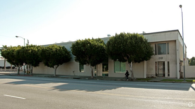

This Property Is For Sale
NEARBY LISTINGS FOR SALE OR LEASE
Property Detail
2723 S La Cienega Blvd
Los Angeles-Long Beach-Glendale, CA
6447
5065-004-025
TRACT NO 6447 LOTS 14, 15, 16, 17, 18, 19 AND LOT 20 BLK B
Lightindustrial
Los Angeles
A
California
06037C1595G
14
2024
0.40 AC
2025
Westside
270200
Los Angeles
28,987 SF
DEMOGRAPHICS near 2723 S La Cienega Blvd
1 Mile
3 Mile
5 Mile
2024 Total Population
33,338
329,330
979,461
2029 Population
32,524
321,709
957,532
Pop Growth 2024-2029
(2.44%)
(2.31%)
(2.24%)
Average Age
39
40
40
2024 Total Households
11,991
141,424
412,591
HH Growth 2024-2029
(2.72%)
(2.50%)
(2.36%)
Median Household Inc
$80,275
$86,049
$78,223
Avg Household Size
2.60
2.20
2.20
2024 Avg HH Vehicles
2.00
2.00
1.00
Median Home Value
$1,045,552
$1,062,647
$1,039,992
Median Year Built
1954
1958
1962
Nearby Places
Map Layers
Map Styles
 Street
 Aerial
- Restaurants
- Banks
- Shops
- Fitness
- Groceries
PUBLIC TRANSPORTATION
TRANSIT/SUBWAY
La Cienega/Jefferson (Expo Line - Los Angeles County Metropolitan Transportation Authority (Metro))
DRIVE
WALK
Distance
La Cienega/Jefferson (Expo Line - Los Angeles County Metropolitan Transportation Authority (Metro))
1 min
11 min
0.6 mi
Culver City (Expo Line - Los Angeles County Metropolitan Transportation Authority (Metro))
DRIVE
WALK
Distance
Culver City (Expo Line - Los Angeles County Metropolitan Transportation Authority (Metro))
2 min
18 min
1.0 mi
COMMUTER RAIL
Los Angeles (Coast Starlight - Amtrak, Pacific Surfliner - Amtrak, Southwest Chief - Amtrak, Texas Eagle - Amtrak)
DRIVE
WALK
Distance
Los Angeles (Coast Starlight - Amtrak, Pacific Surfliner - Amtrak, Southwest Chief - Amtrak, Texas Eagle - Amtrak)
14 min
9.3 mi
Union Station (91 Line - Southern California Regional Rail Authority (Metrolink), Antelope Valley Line - Southern California Regional Rail Authority (Metrolink), Orange County Line - Southern California Regional Rail Authority (Metrolink), Riverside Line - Southern California Regional Rail Authority (Metrolink), San Bernardino Line - Southern California Regional Rail Authority (Metrolink), Ventura County Line - Southern California Regional Rail Authority (Metrolink))
DRIVE
WALK
Distance
Union Station (91 Line - Southern California Regional Rail Authority (Metrolink), Antelope Valley Line - Southern California Regional Rail Authority (Metrolink), Orange County Line - Southern California Regional Rail Authority (Metrolink), Riverside Line - Southern California Regional Rail Authority (Metrolink), San Bernardino Line - Southern California Regional Rail Authority (Metrolink), Ventura County Line - Southern California Regional Rail Authority (Metrolink))
16 min
9.4 mi
AIRPORT
Los Angeles International
DRIVE
WALK
Distance
Los Angeles International
15 min
7.8 mi
Bob Hope
DRIVE
WALK
Distance
Bob Hope
29 min
14.7 mi
Long Beach (Daugherty Field)
DRIVE
WALK
Distance
Long Beach (Daugherty Field)
33 min
24.2 mi
Freight Ports
Port of Long Beach
DRIVE
WALK
Distance
Port of Long Beach
36 min
26.1 mi
Nearby Properties
Address
Land Use
TOTAL SIZE
Lot Size
Zoning
Address
Land Use
TOTAL SIZE
Lot Size
Zoning
2,529,036 SF
8.48 AC
LAC2
Address
Land Use
TOTAL SIZE
Lot Size
Zoning
1,447,077 SF
10.63 AC
LAC2
Address
Land Use
TOTAL SIZE
Lot Size
Zoning
157,691 SF
45.86 AC
CCS1*
Address
Land Use
TOTAL SIZE
Lot Size
Zoning
436,774 SF
1.49 AC
LAC2
Address
Land Use
TOTAL SIZE
Lot Size
Zoning
1,353,044 SF
6.18 AC
LAC2
Address
Land Use
TOTAL SIZE
Lot Size
Zoning
1,002,990 SF
8.42 AC
LAC4
Address
Land Use
TOTAL SIZE
Lot Size
Zoning
5.57 AC
LAC2
Address
Land Use
TOTAL SIZE
Lot Size
Zoning
33,373 SF
52.98 AC
LACCS
Address
Land Use
TOTAL SIZE
Lot Size
Zoning
346,856 SF
3.67 AC
CCC3*
Address
Land Use
TOTAL SIZE
Lot Size
Zoning
840,124 SF
2.77 AC
LAC2
Address
Land Use
TOTAL SIZE
Lot Size
Zoning
252,523 SF
2.26 AC
LAC2
Address
Land Use
TOTAL SIZE
Lot Size
Zoning
597,713 SF
11.18 AC
CCS1YY
Address
Land Use
TOTAL SIZE
Lot Size
Zoning
1,232,625 SF
2.40 AC
LAC2
Address
Land Use
TOTAL SIZE
Lot Size
Zoning
1,226,598 SF
2.30 AC
LAC2
Address
Land Use
TOTAL SIZE
Lot Size
Zoning
32,180 SF
BHC3*
Address
Land Use
TOTAL SIZE
Lot Size
Zoning
824,156 SF
2.15 AC
LAC2
Address
Land Use
TOTAL SIZE
Lot Size
Zoning
767,078 SF
9.30 AC
LAC2
Address
Land Use
TOTAL SIZE
Lot Size
Zoning
871,235 SF
14.56 AC
LAC2
Address
Land Use
TOTAL SIZE
Lot Size
Zoning
476,779 SF
1.57 AC
LAC4
Address
Land Use
TOTAL SIZE
Lot Size
Zoning
133,959 SF
1.23 AC
BHC3*
Address
Land Use
TOTAL SIZE
Lot Size
Zoning
754,581 SF
3.75 AC
LAC1
Address
Land Use
TOTAL SIZE
Lot Size
Zoning
728,063 SF
2.08 AC
LAC4
Address
Land Use
TOTAL SIZE
Lot Size
Zoning
472,363 SF
3.24 AC
LAC4
Address
Land Use
TOTAL SIZE
Lot Size
Zoning
808,626 SF
1.88 AC
LAC2
Address
Land Use
TOTAL SIZE
Lot Size
Zoning
368,411 SF
10.91 AC
C2-2D-CPIO
Address
Land Use
TOTAL SIZE
Lot Size
Zoning
793,274 SF
7.80 AC
LAR4
Address
Land Use
TOTAL SIZE
Lot Size
Zoning
110,580 SF
6.88 AC
LAC2
Address
Land Use
TOTAL SIZE
Lot Size
Zoning
1,572,709 SF
4.34 AC
LAC2
Address
Land Use
TOTAL SIZE
Lot Size
Zoning
1,057,271 SF
2.50 AC
LAC2
Address
Land Use
TOTAL SIZE
Lot Size
Zoning
453,182 SF
2.76 AC
LAC4
The World's #1 Commercial Real Estate Marketplace
Connect with us
© 2025 CoStar Group
The information above has been obtained from sources believed reliable. While we do not doubt its accuracy we have not verified it and make no guarantee, warranty or representation about it. It is your responsibility to independently confirm its accuracy and completeness. Any projections, opinions, assumptions, or estimates used are for example only and do not represent the current or future performance of the property. The value of this transaction to you depends on tax and other factors which should be evaluated by your tax, financial, and legal advisors. You and your advisors should conduct a careful, independent investigation of the property to determine to your satisfaction the suitability of the property for your needs.