Property Record
2724 5Th Ave S, Irondale, AL 35210


NEARBY LISTINGS FOR SALE OR LEASE
Property Detail
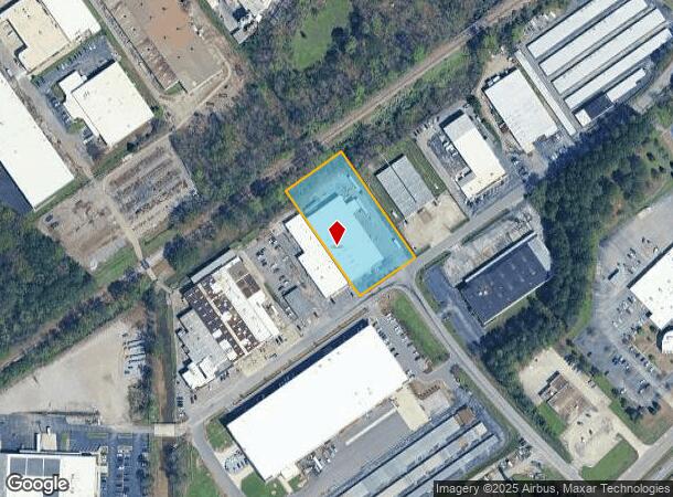
2724 5Th Ave S
Birmingham-Hoover, AL
Irondl Indust Park23-24-1
23-00-24-1-006-005.000
LOT 9 IRONDALE INDUSTRIAL PARK 1ST ADD
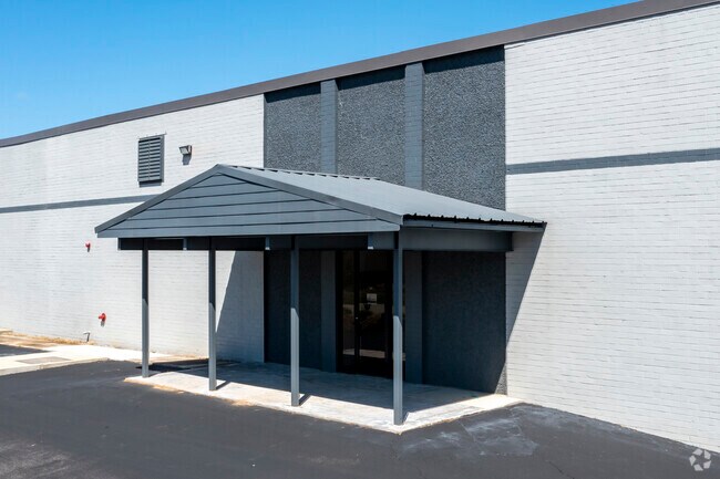
Warehouse
Jefferson
AE
Alabama
01073C0412H
9
2023
1.75 AC
2024
Trussville
012701
Birmingham
28,125 SF
DEMOGRAPHICS near 2724 5Th Ave S
1 Mile
3 Mile
5 Mile
2024 Total Population
2,064
39,397
91,544
2029 Population
2,025
39,022
90,073
Pop Growth 2024-2029
(1.89%)
(0.95%)
(1.61%)
Average Age
41
40
39
2024 Total Households
979
16,190
36,734
HH Growth 2024-2029
(1.94%)
(1.18%)
(1.70%)
Median Household Inc
$65,633
$50,778
$58,956
Avg Household Size
2.10
2.30
2.40
2024 Avg HH Vehicles
2.00
2.00
2.00
Median Home Value
$183,695
$175,535
$228,343
Median Year Built
1975
1968
1967
Nearby Places
Map Layers
Map Styles
 Street
 Aerial
- Restaurants
- Banks
- Shops
- Fitness
- Groceries
PUBLIC TRANSPORTATION
COMMUTER RAIL
DRIVE
WALK
Distance
13 min
7.8 mi
AIRPORT
Birmingham-Shuttlesworth International
DRIVE
WALK
Distance
Birmingham-Shuttlesworth International
10 min
5.7 mi
SALE & LEASE HISTORY
LISTING DATE
SALE/LEASE

Nov 21, 2017
For Lease
Feb 28, 2017
For Sale
Dec 16, 2020
For Lease
Nearby Properties
Address
Land Use
TOTAL SIZE
Lot Size
Zoning
Address
Land Use
TOTAL SIZE
Lot Size
Zoning
166,863 SF
21 AC
CB2
Address
Land Use
TOTAL SIZE
Lot Size
Zoning
80,288 SF
2.91 AC
CB2
Address
Land Use
TOTAL SIZE
Lot Size
Zoning
423,995 SF
25 AC
R3
Address
Land Use
TOTAL SIZE
Lot Size
Zoning
144,135 SF
31.95 AC
CR5
Address
Land Use
TOTAL SIZE
Lot Size
Zoning
158,161 SF
15.48 AC
C1
Address
Land Use
TOTAL SIZE
Lot Size
Zoning
125,324 SF
53 AC
INST
Address
Land Use
TOTAL SIZE
Lot Size
Zoning
137,168 SF
63 AC
A1
Address
Land Use
TOTAL SIZE
Lot Size
Zoning
297,391 SF
27.10 AC
CR5
Address
Land Use
TOTAL SIZE
Lot Size
Zoning
131,319 SF
13.28 AC
CB2
Address
Land Use
TOTAL SIZE
Lot Size
Zoning
235,552 SF
10.13 AC
R3
Address
Land Use
TOTAL SIZE
Lot Size
Zoning
168,744 SF
8.46 AC
I1
Address
Land Use
TOTAL SIZE
Lot Size
Zoning
22 AC
CB2
Address
Land Use
TOTAL SIZE
Lot Size
Zoning
210,920 SF
22.41 AC
CB2
Address
Land Use
TOTAL SIZE
Lot Size
Zoning
145,949 SF
10.01 AC
QR6
Address
Land Use
TOTAL SIZE
Lot Size
Zoning
102,748 SF
8.50 AC
CB2
Address
Land Use
TOTAL SIZE
Lot Size
Zoning
8.10 AC
QR6
Address
Land Use
TOTAL SIZE
Lot Size
Zoning
223,365 SF
15 AC
I1
Address
Land Use
TOTAL SIZE
Lot Size
Zoning
43,566 SF
18.99 AC
C1
Address
Land Use
TOTAL SIZE
Lot Size
Zoning
150,750 SF
12.60 AC
CR5
Address
Land Use
TOTAL SIZE
Lot Size
Zoning
52,416 SF
7 AC
A1
Address
Land Use
TOTAL SIZE
Lot Size
Zoning
301,531 SF
41 AC
B5
Address
Land Use
TOTAL SIZE
Lot Size
Zoning
188,160 SF
14 AC
CB2
Address
Land Use
TOTAL SIZE
Lot Size
Zoning
113,014 SF
8 AC
I1
Address
Land Use
TOTAL SIZE
Lot Size
Zoning
104,000 SF
7.66 AC
I1
Address
Land Use
TOTAL SIZE
Lot Size
Zoning
47,720 SF
5.21 AC
QB2
Address
Land Use
TOTAL SIZE
Lot Size
Zoning
64,859 SF
105 AC
INST
Address
Land Use
TOTAL SIZE
Lot Size
Zoning
97,021 SF
17.50 AC
R1
Address
Land Use
TOTAL SIZE
Lot Size
Zoning
71,028 SF
9.90 AC
O-I
Address
Land Use
TOTAL SIZE
Lot Size
Zoning
63,798 SF
4.18 AC
I1
Address
Land Use
TOTAL SIZE
Lot Size
Zoning
119,300 SF
7.72 AC
I1
The World's #1 Commercial Real Estate Marketplace
Connect with us
© 2025 CoStar Group
The information above has been obtained from sources believed reliable. While we do not doubt its accuracy we have not verified it and make no guarantee, warranty or representation about it. It is your responsibility to independently confirm its accuracy and completeness. Any projections, opinions, assumptions, or estimates used are for example only and do not represent the current or future performance of the property. The value of this transaction to you depends on tax and other factors which should be evaluated by your tax, financial, and legal advisors. You and your advisors should conduct a careful, independent investigation of the property to determine to your satisfaction the suitability of the property for your needs.