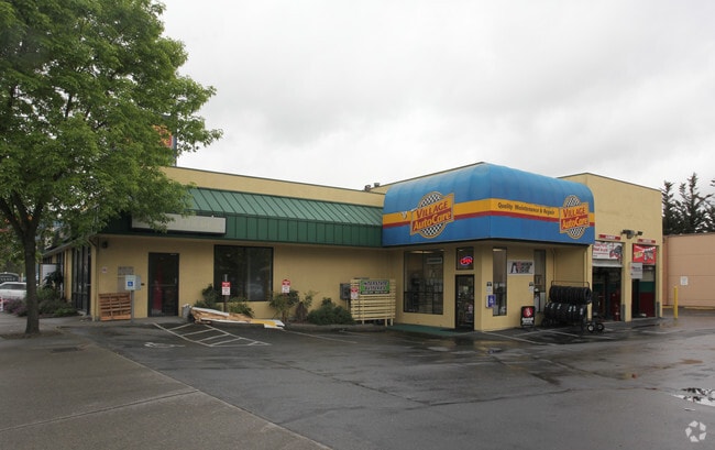
Property Record
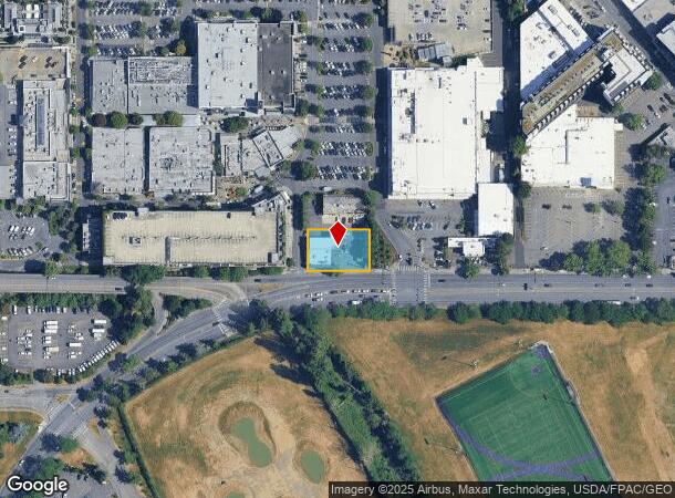
2724 Ne 45Th St, Seattle, WA 98105


NEARBY LISTINGS FOR SALE OR LEASE
Property Detail
2724 Ne 45Th St
Seattle-Tacoma-Bellevue, WA
Sp 820581
092504-9372
PAR A SEA SP #82-0581 REC # 8305230824 REVISED REC # 8308040644 SD SP DAF BAAP ON N MGN NE 45TH ST 30.5 FT W OF W LN OF E 1/2 OF SE 1/4 OF SW 1/4 OF SE 1/4 SEC 9-25-4 TH N 86-56-56 W ALG SD N MGN 149 FT TH N 00-13-43 W 175 FT TH S 89-56-56 E 149 FT T
Storebuilding
King
X
Washington
53033C0345G
a
2025
0.34 AC
2024
Ballard/U Dist
004301
Seattle/Puget Sound
4,880 SF
DEMOGRAPHICS near 2724 Ne 45Th St
1 Mile
3 Mile
5 Mile
2024 Total Population
37,182
205,292
575,204
2029 Population
37,766
207,590
584,316
Pop Growth 2024-2029
+ 1.57%
+ 1.12%
+ 1.58%
Average Age
31
37
38
2024 Total Households
14,147
93,438
282,730
HH Growth 2024-2029
+ 2.02%
+ 1.18%
+ 1.68%
Median Household Inc
$61,285
$123,945
$116,459
Avg Household Size
2.00
2.00
1.90
2024 Avg HH Vehicles
1.00
1.00
1.00
Median Home Value
$1,048,643
$1,034,239
$975,384
Median Year Built
1976
1966
1980
Nearby Places
Map Layers
Map Styles
 Street
 Aerial
- Restaurants
- Banks
- Shops
- Fitness
- Groceries
PUBLIC TRANSPORTATION
TRANSIT/SUBWAY
U District Station (Lynnwood - Angle Lake - Sound Transit, Northgate - Angle Lake - Sound Transit)
DRIVE
WALK
Distance
U District Station (Lynnwood - Angle Lake - Sound Transit, Northgate - Angle Lake - Sound Transit)
3 min
17 min
0.9 mi
Univ Of Washington Station (Lynnwood - Angle Lake - Sound Transit, Northgate - Angle Lake - Sound Transit)
DRIVE
WALK
Distance
Univ Of Washington Station (Lynnwood - Angle Lake - Sound Transit, Northgate - Angle Lake - Sound Transit)
3 min
19 min
1.0 mi
COMMUTER RAIL
King Street (Seattle) Station (Everett - Seattle - Sound Transit, Seattle - Tacoma/Lakewood - Sound Transit, Sounder South Line - Sound Transit)
DRIVE
WALK
Distance
King Street (Seattle) Station (Everett - Seattle - Sound Transit, Seattle - Tacoma/Lakewood - Sound Transit, Sounder South Line - Sound Transit)
11 min
5.5 mi
AIRPORT
Seattle-Tacoma International
DRIVE
WALK
Distance
Seattle-Tacoma International
30 min
18.8 mi
Seattle Paine Field International
DRIVE
WALK
Distance
Seattle Paine Field International
32 min
20.8 mi
Freight Ports
Port of Seattle
DRIVE
WALK
Distance
Port of Seattle
17 min
9.3 mi
SALE & LEASE HISTORY
LISTING DATE
SALE/LEASE

Mar 17, 2017
For Lease
Nearby Properties
Address
Land Use
TOTAL SIZE
Lot Size
Zoning
Address
Land Use
TOTAL SIZE
Lot Size
Zoning
471.20 AC
MIO-37-LR1
Address
Land Use
TOTAL SIZE
Lot Size
Zoning
26,850 SF
194.66 AC
NR2
Address
Land Use
TOTAL SIZE
Lot Size
Zoning
107.86 AC
NR2
Address
Land Use
TOTAL SIZE
Lot Size
Zoning
50,060 SF
96.12 AC
NR2
Address
Land Use
TOTAL SIZE
Lot Size
Zoning
612,844 SF
0.09 AC
SM-U/R 75-
Address
Land Use
TOTAL SIZE
Lot Size
Zoning
90,184 SF
16.66 AC
C1-75 (M)
Address
Land Use
TOTAL SIZE
Lot Size
Zoning
107.93 AC
NR3
Address
Land Use
TOTAL SIZE
Lot Size
Zoning
42,500 SF
90.92 AC
NR3
Address
Land Use
TOTAL SIZE
Lot Size
Zoning
444,757 SF
0.30 AC
SM-SLU 145
Address
Land Use
TOTAL SIZE
Lot Size
Zoning
310,584 SF
1.18 AC
C1-55 (M)
Address
Land Use
TOTAL SIZE
Lot Size
Zoning
301,245 SF
22.34 AC
LR3 (M)
Address
Land Use
TOTAL SIZE
Lot Size
Zoning
25,735 SF
1.56 AC
C1-75 (M)
Address
Land Use
TOTAL SIZE
Lot Size
Zoning
198,256 SF
0.47 AC
SM-SLU 145
Address
Land Use
TOTAL SIZE
Lot Size
Zoning
226,265 SF
1.58 AC
NC3P-75 (M
Address
Land Use
TOTAL SIZE
Lot Size
Zoning
285,140 SF
0.90 AC
NC2-75 (M1
Address
Land Use
TOTAL SIZE
Lot Size
Zoning
131,790 SF
0.37 AC
SM-U 75-24
Address
Land Use
TOTAL SIZE
Lot Size
Zoning
349,530 SF
0.37 AC
SM-SLU 145
Address
Land Use
TOTAL SIZE
Lot Size
Zoning
6.87 AC
MIO-200-C1
Address
Land Use
TOTAL SIZE
Lot Size
Zoning
126,394 SF
8.80 AC
C2-75 (M)
Address
Land Use
TOTAL SIZE
Lot Size
Zoning
232,656 SF
0.89 AC
SM-SLU 100
Address
Land Use
TOTAL SIZE
Lot Size
Zoning
223,047 SF
0.18 AC
NC2P-75 (M
Address
Land Use
TOTAL SIZE
Lot Size
Zoning
382,762 SF
7.14 AC
NR3
Address
Land Use
TOTAL SIZE
Lot Size
Zoning
0.31 AC
SM-U 95-32
Address
Land Use
TOTAL SIZE
Lot Size
Zoning
132,183 SF
0.76 AC
NC2-65
Address
Land Use
TOTAL SIZE
Lot Size
Zoning
1,100 SF
18.83 AC
UI U/45
Address
Land Use
TOTAL SIZE
Lot Size
Zoning
64,251 SF
45 AC
NR3
Address
Land Use
TOTAL SIZE
Lot Size
Zoning
281,306 SF
1.15 AC
C1-75 (M)
Address
Land Use
TOTAL SIZE
Lot Size
Zoning
6,534 SF
0.55 AC
IC-65 (M)
The World's #1 Commercial Real Estate Marketplace
Connect with us
© 2025 CoStar Group
The information above has been obtained from sources believed reliable. While we do not doubt its accuracy we have not verified it and make no guarantee, warranty or representation about it. It is your responsibility to independently confirm its accuracy and completeness. Any projections, opinions, assumptions, or estimates used are for example only and do not represent the current or future performance of the property. The value of this transaction to you depends on tax and other factors which should be evaluated by your tax, financial, and legal advisors. You and your advisors should conduct a careful, independent investigation of the property to determine to your satisfaction the suitability of the property for your needs.