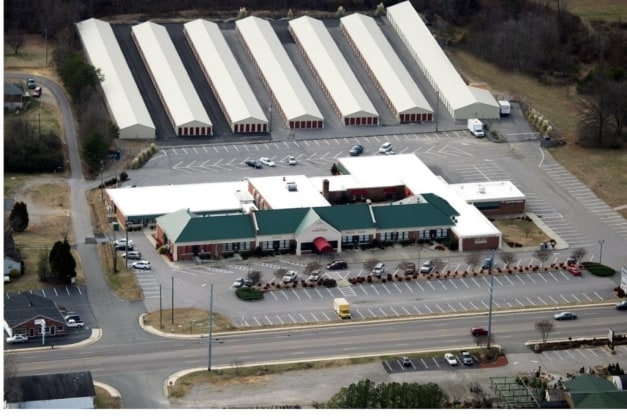
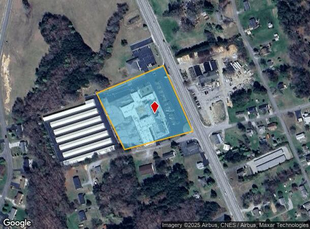
Property Record
2725 Franklin Tpke, Danville, VA 24540
Current Lease Availabilities
NEARBY LISTINGS FOR SALE OR LEASE
-
-
View all Danville listings for lease on LoopNet.com
Property Detail
2725 Franklin Tpke
2410-50-3336
FRANKLIN TPKE 41 TRACT B1A
Commercialnec
Pittsylvania
X
Virginia
51143C0520E
4.39 AC
2025
Virginia South Central
2025
Other Market Areas
011301
Danville, VA
40,000 SF
DEMOGRAPHICS near 2725 Franklin Tpke
1 Mile
3 Mile
5 Mile
2024 Total Population
2,421
14,155
32,769
2029 Population
2,362
13,801
32,270
Pop Growth 2024-2029
(2.44%)
(2.50%)
(1.52%)
Average Age
41
42
43
2024 Total Households
995
6,065
14,001
HH Growth 2024-2029
(2.41%)
(2.51%)
(1.54%)
Median Household Inc
$59,887
$51,572
$41,837
Avg Household Size
2.30
2.30
2.20
2024 Avg HH Vehicles
2.00
2.00
2.00
Median Home Value
$158,678
$147,929
$124,828
Median Year Built
1985
1977
1970
Nearby Places
Map Layers
Map Styles
 Street
 Aerial
- Restaurants
- Banks
- Shops
- Fitness
- Groceries
PUBLIC TRANSPORTATION
COMMUTER RAIL
Danville Amtrak Station (Crescent - Amtrak)
DRIVE
WALK
Distance
Danville Amtrak Station (Crescent - Amtrak)
10 min
6.2 mi
Freight Ports
Virginia Port Authority - Richmond
DRIVE
WALK
Distance
Virginia Port Authority - Richmond
193 min
145.9 mi
Nearby Properties
Address
Land Use
TOTAL SIZE
Lot Size
Zoning
Address
Land Use
TOTAL SIZE
Lot Size
Zoning
12.20 AC
B-2
Address
Land Use
TOTAL SIZE
Lot Size
Zoning
77,952 SF
16.59 AC
TRANSITION
Address
Land Use
TOTAL SIZE
Lot Size
Zoning
19.90 AC
R-1
Address
Land Use
TOTAL SIZE
Lot Size
Zoning
2,516 SF
19.75 AC
DZ
Address
Land Use
TOTAL SIZE
Lot Size
Zoning
75,816 SF
7.04 AC
COND MULTI
Address
Land Use
TOTAL SIZE
Lot Size
Zoning
160,199 SF
15.90 AC
PLANNED SH
Address
Land Use
TOTAL SIZE
Lot Size
Zoning
26,593 SF
15.64 AC
MULTI-FAMI
Address
Land Use
TOTAL SIZE
Lot Size
Zoning
60,590 SF
5.30 AC
OLD TOWN R
Address
Land Use
TOTAL SIZE
Lot Size
Zoning
9,200 SF
5.41 AC
R-1
Address
Land Use
TOTAL SIZE
Lot Size
Zoning
7,796 SF
8.43 AC
MULTI-FAMI
Address
Land Use
TOTAL SIZE
Lot Size
Zoning
21.40 AC
A-1
Address
Land Use
TOTAL SIZE
Lot Size
Zoning
16,500 SF
7 AC
MULTI-FAMI
Address
Land Use
TOTAL SIZE
Lot Size
Zoning
504 SF
8.33 AC
TRANSITION
Address
Land Use
TOTAL SIZE
Lot Size
Zoning
8.52 AC
B-2
Address
Land Use
TOTAL SIZE
Lot Size
Zoning
20.17 AC
M-1
Address
Land Use
TOTAL SIZE
Lot Size
Zoning
43,942 SF
14.62 AC
NEIGHBORHO
Address
Land Use
TOTAL SIZE
Lot Size
Zoning
34,653 SF
8.87 AC
NEIGHBORHO
Address
Land Use
TOTAL SIZE
Lot Size
Zoning
2,788 SF
5.38 AC
RMF
Address
Land Use
TOTAL SIZE
Lot Size
Zoning
4.08 AC
B-2
Address
Land Use
TOTAL SIZE
Lot Size
Zoning
129,864 SF
14.35 AC
M-1
Address
Land Use
TOTAL SIZE
Lot Size
Zoning
14,550 SF
2.06 AC
HIGHWAY RE
Address
Land Use
TOTAL SIZE
Lot Size
Zoning
23,046 SF
1.38 AC
OLD TOWN R
Address
Land Use
TOTAL SIZE
Lot Size
Zoning
31,816 SF
1.62 AC
MULTI-FAMI
Address
Land Use
TOTAL SIZE
Lot Size
Zoning
9,728 SF
3.45 AC
M-1
Address
Land Use
TOTAL SIZE
Lot Size
Zoning
41,490 SF
2.91 AC
HIGHWAY RE
Address
Land Use
TOTAL SIZE
Lot Size
Zoning
5,980 SF
2.58 AC
B-2
Address
Land Use
TOTAL SIZE
Lot Size
Zoning
7,440 SF
3.89 AC
MULTI-FAMI
Address
Land Use
TOTAL SIZE
Lot Size
Zoning
2,128 SF
9.59 AC
B-2
Address
Land Use
TOTAL SIZE
Lot Size
Zoning
83,988 SF
6.89 AC
MULTI-FAMI
Address
Land Use
TOTAL SIZE
Lot Size
Zoning
13,060 SF
0.85 AC
PLANNED SH
The World's #1 Commercial Real Estate Marketplace
Connect with us
© 2025 CoStar Group
The information above has been obtained from sources believed reliable. While we do not doubt its accuracy we have not verified it and make no guarantee, warranty or representation about it. It is your responsibility to independently confirm its accuracy and completeness. Any projections, opinions, assumptions, or estimates used are for example only and do not represent the current or future performance of the property. The value of this transaction to you depends on tax and other factors which should be evaluated by your tax, financial, and legal advisors. You and your advisors should conduct a careful, independent investigation of the property to determine to your satisfaction the suitability of the property for your needs.