Property Record
2725 S 6Th St, Klamath Falls, OR 97603
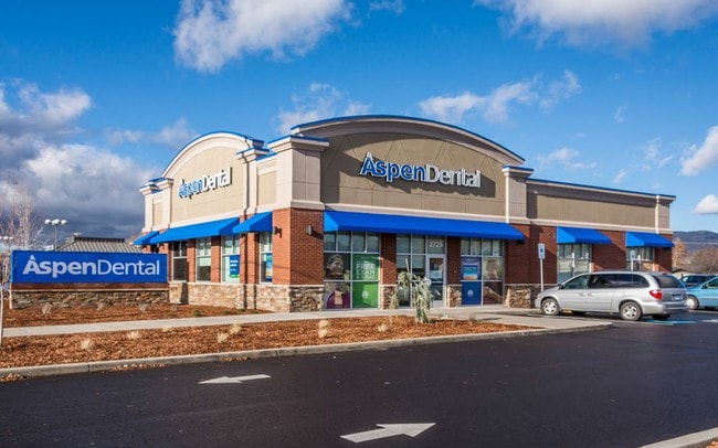
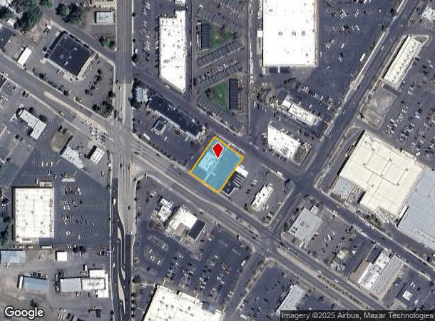

Property Detail
2725 S 6Th St
Officebuilding
TWP 39 RNGE 9, BLOCK SEC 3, TRACT POR SW4NW4NW4 LESS PLA 02-16, ACRES 0.55
X
Klamath
41035C2734C
Oregon
2025
0.53 AC
2025
Other Market Areas
971600
Klamath Falls, OR
3,500 SF
R526274
NEARBY LISTINGS FOR SALE OR LEASE
DEMOGRAPHICS near 2725 S 6Th St
1 mile
3 mile
5 mile
2024 Total Population
5,696
39,316
48,323
2029 Population
5,866
40,711
50,125
Pop Growth 2024-2029
+ 2.98%
+ 3.55%
+ 3.73%
Average Age
37
39
39
2024 Total Households
2,518
16,082
19,577
HH Growth 2024-2029
+ 2.90%
+ 3.56%
+ 3.72%
Median Household Inc
$27,899
$41,516
$44,755
Avg Household Size
2.20
2.30
2.30
2024 Avg HH Vehicles
1.00
2.00
2.00
Median Home Value
$129,052
$196,798
$219,089
Median Year Built
1958
1969
1971
Nearby Places
Map Layers
Map Styles
 Street
 Aerial
Transit
 Traffic
 Biking
Places
Listings with unknown addresses are not visible on the map
- Restaurants
- Banks
- Shops
- Fitness
- Groceries
PUBLIC TRANSPORTATION
COMMUTER RAIL
Drive
Walk
Distance
5 min
2.2 mi
Nearby Properties
Address
Land Use
TOTAL SIZE
Lot Size
Zoning
Address
Land Use
TOTAL SIZE
Lot Size
Zoning
Address
Land Use
TOTAL SIZE
Lot Size
Zoning
784 SF
5.73 AC
I
Address
Land Use
TOTAL SIZE
Lot Size
Zoning
3.92 AC
MU
Address
Land Use
TOTAL SIZE
Lot Size
Zoning
211,167 SF
14.23 AC
GC
Address
Land Use
TOTAL SIZE
Lot Size
Zoning
179,904 SF
13.90 AC
GC
Address
Land Use
TOTAL SIZE
Lot Size
Zoning
66,904 SF
36.90 AC
PF
Address
Land Use
TOTAL SIZE
Lot Size
Zoning
145,149 SF
4.90 AC
PF
Address
Land Use
TOTAL SIZE
Lot Size
Zoning
940 SF
37.21 AC
CR
Address
Land Use
TOTAL SIZE
Lot Size
Zoning
57,008 SF
1.43 AC
PF
Address
Land Use
TOTAL SIZE
Lot Size
Zoning
34.73 AC
IH
Address
Land Use
TOTAL SIZE
Lot Size
Zoning
65,600 SF
26.50 AC
PF
Address
Land Use
TOTAL SIZE
Lot Size
Zoning
30,390 SF
12.63 AC
RS
Address
Land Use
TOTAL SIZE
Lot Size
Zoning
22,500 SF
4 AC
LI
Address
Land Use
TOTAL SIZE
Lot Size
Zoning
6.29 AC
L1
Address
Land Use
TOTAL SIZE
Lot Size
Zoning
61,045 SF
2.44 AC
A
Address
Land Use
TOTAL SIZE
Lot Size
Zoning
97,248 SF
12.65 AC
CG
Address
Land Use
TOTAL SIZE
Lot Size
Zoning
7,432 SF
0.16 AC
A
Address
Land Use
TOTAL SIZE
Lot Size
Zoning
7.38 AC
I
Address
Land Use
TOTAL SIZE
Lot Size
Zoning
56,286 SF
12.15 AC
RS
Address
Land Use
TOTAL SIZE
Lot Size
Zoning
2.46 AC
MU
Address
Land Use
TOTAL SIZE
Lot Size
Zoning
108,500 SF
19.90 AC
IH
Address
Land Use
TOTAL SIZE
Lot Size
Zoning
4,524 SF
0.88 AC
MD,GC
Address
Land Use
TOTAL SIZE
Lot Size
Zoning
41,938 SF
1.45 AC
PF
Address
Land Use
TOTAL SIZE
Lot Size
Zoning
1 SF
10.06 AC
IH
Address
Land Use
TOTAL SIZE
Lot Size
Zoning
29,106 SF
8.76 AC
GC
Address
Land Use
TOTAL SIZE
Lot Size
Zoning
20,430 SF
2.96 AC
MD,GC
Address
Land Use
TOTAL SIZE
Lot Size
Zoning
66,490 SF
5.68 AC
GC
Address
Land Use
TOTAL SIZE
Lot Size
Zoning
Address
Land Use
TOTAL SIZE
Lot Size
Zoning
50,892 SF
5.67 AC
CG
Address
Land Use
TOTAL SIZE
Lot Size
Zoning
4.06 AC
PF
The World's #1 Commercial Real Estate Marketplace
Connect with us
© 2026 CoStar Group
The information above has been obtained from sources believed reliable. While we do not doubt its accuracy we have not verified it and make no guarantee, warranty or representation about it. It is your responsibility to independently confirm its accuracy and completeness. Any projections, opinions, assumptions, or estimates used are for example only and do not represent the current or future performance of the property. The value of this transaction to you depends on tax and other factors which should be evaluated by your tax, financial, and legal advisors. You and your advisors should conduct a careful, independent investigation of the property to determine to your satisfaction the suitability of the property for your needs.