Property Record
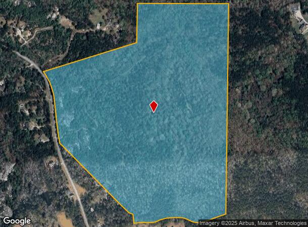
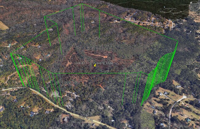
2725 White Rd Ne, Conyers, GA 30012


NEARBY LISTINGS FOR SALE OR LEASE
-
-
View all Conyers listings for sale on LoopNet.com
Property Detail
2725 White Rd Ne
Atlanta-Sandy Springs-Roswell, GA
Rural
086-0-01-0001
E/SIDE WHITE RD
Privatepreserveopenspacevacantlandforestlandconservation
Rockdale
X
Georgia
13247C0104D
359
2024
113.73 AC
2025
I-20 East/Conyers
060103
Atlanta
DEMOGRAPHICS near 2725 White Rd Ne
1 Mile
3 Mile
5 Mile
2024 Total Population
758
12,344
42,601
2029 Population
798
12,905
45,017
Pop Growth 2024-2029
+ 5.28%
+ 4.54%
+ 5.67%
Average Age
45
41
39
2024 Total Households
300
4,334
14,821
HH Growth 2024-2029
+ 5.33%
+ 4.61%
+ 5.70%
Median Household Inc
$64,861
$72,291
$63,230
Avg Household Size
2.50
2.70
2.80
2024 Avg HH Vehicles
2.00
2.00
2.00
Median Home Value
$237,142
$223,740
$213,867
Median Year Built
1988
1992
1990
Nearby Places
Map Layers
Map Styles
 Street
 Aerial
- Restaurants
- Banks
- Shops
- Fitness
- Groceries
PUBLIC TRANSPORTATION
AIRPORT
Hartsfield - Jackson Atlanta International
DRIVE
WALK
Distance
Hartsfield - Jackson Atlanta International
50 min
35.1 mi
Freight Ports
Georgia Ports - Savannah
DRIVE
WALK
Distance
Georgia Ports - Savannah
286 min
244.0 mi
SALE & LEASE HISTORY
LISTING DATE
SALE/LEASE

Oct 30, 2018
For Sale
Nov 21, 2016
For Sale
Nov 08, 2023
For Sale
Jun 14, 2024
For Sale
Jan 15, 2018
For Sale
Aug 28, 2019
For Sale
Aug 02, 2017
For Sale
Nearby Properties
Address
Land Use
TOTAL SIZE
Lot Size
Zoning
Address
Land Use
TOTAL SIZE
Lot Size
Zoning
362,852 SF
18.42 AC
RM24
Address
Land Use
TOTAL SIZE
Lot Size
Zoning
7,806 SF
32.76 AC
RM
Address
Land Use
TOTAL SIZE
Lot Size
Zoning
180,890 SF
45.15 AC
R1
Address
Land Use
TOTAL SIZE
Lot Size
Zoning
286.57 AC
RES AG
Address
Land Use
TOTAL SIZE
Lot Size
Zoning
71.95 AC
R1
Address
Land Use
TOTAL SIZE
Lot Size
Zoning
66,181 SF
25.46 AC
R1A
Address
Land Use
TOTAL SIZE
Lot Size
Zoning
7,020 SF
29.06 AC
RES AG
Address
Land Use
TOTAL SIZE
Lot Size
Zoning
34,370 SF
5.04 AC
OI
Address
Land Use
TOTAL SIZE
Lot Size
Zoning
11,000 SF
56.32 AC
R3/C
Address
Land Use
TOTAL SIZE
Lot Size
Zoning
653.65 AC
WP
Address
Land Use
TOTAL SIZE
Lot Size
Zoning
9,869 SF
3.20 AC
C1/C
Address
Land Use
TOTAL SIZE
Lot Size
Zoning
6,976 SF
4 AC
RES AG
Address
Land Use
TOTAL SIZE
Lot Size
Zoning
5,500 SF
2.11 AC
C1
Address
Land Use
TOTAL SIZE
Lot Size
Zoning
14,620 SF
2.60 AC
R1
Address
Land Use
TOTAL SIZE
Lot Size
Zoning
38.50 AC
R3C2C1OI(C
Address
Land Use
TOTAL SIZE
Lot Size
Zoning
13,500 SF
1.18 AC
R1
Address
Land Use
TOTAL SIZE
Lot Size
Zoning
8,433 SF
2.18 AC
C1/C
Address
Land Use
TOTAL SIZE
Lot Size
Zoning
10,493 SF
11.96 AC
R1/R1A
Address
Land Use
TOTAL SIZE
Lot Size
Zoning
10,770 SF
1.93 AC
BG
Address
Land Use
TOTAL SIZE
Lot Size
Zoning
1,064 SF
4.10 AC
WP
Address
Land Use
TOTAL SIZE
Lot Size
Zoning
160 AC
WP
Address
Land Use
TOTAL SIZE
Lot Size
Zoning
221.84 AC
WP
Address
Land Use
TOTAL SIZE
Lot Size
Zoning
170 AC
WP
Address
Land Use
TOTAL SIZE
Lot Size
Zoning
151.99 AC
AR
Address
Land Use
TOTAL SIZE
Lot Size
Zoning
2,040 SF
1.25 AC
WP
Address
Land Use
TOTAL SIZE
Lot Size
Zoning
4,310 SF
7.79 AC
AR
Address
Land Use
TOTAL SIZE
Lot Size
Zoning
117 AC
WP
Address
Land Use
TOTAL SIZE
Lot Size
Zoning
58.17 AC
WP
Address
Land Use
TOTAL SIZE
Lot Size
Zoning
60.27 AC
AR
The World's #1 Commercial Real Estate Marketplace
Connect with us
© 2026 CoStar Group
The information above has been obtained from sources believed reliable. While we do not doubt its accuracy we have not verified it and make no guarantee, warranty or representation about it. It is your responsibility to independently confirm its accuracy and completeness. Any projections, opinions, assumptions, or estimates used are for example only and do not represent the current or future performance of the property. The value of this transaction to you depends on tax and other factors which should be evaluated by your tax, financial, and legal advisors. You and your advisors should conduct a careful, independent investigation of the property to determine to your satisfaction the suitability of the property for your needs.