Property Record
27250 Us Highway 74, Menifee, CA 92585


NEARBY LISTINGS FOR SALE OR LEASE
Property Detail
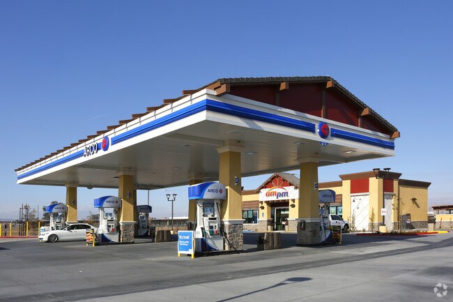
27250 Us Highway 74
Riverside-San Bernardino-Ontario, CA
Romola Farms 6A
329-030-075
.79 ACRES M/L IN POR LOTS 518 & 519 MB 014/063 ROMOLA FARMS 6A
Servicestation
Riverside
X
California
06065C1445H
519
2024
0.79 AC
2025
South Riverside
042730
Inland Empire (California)
3,182 SF
DEMOGRAPHICS near 27250 Us Highway 74
1 Mile
3 Mile
5 Mile
2024 Total Population
2,586
36,347
140,741
2029 Population
2,727
38,588
148,973
Pop Growth 2024-2029
+ 5.45%
+ 6.17%
+ 5.85%
Average Age
36
41
38
2024 Total Households
688
12,238
42,197
HH Growth 2024-2029
+ 5.23%
+ 5.70%
+ 5.44%
Median Household Inc
$87,500
$68,703
$71,378
Avg Household Size
3.50
2.90
3.20
2024 Avg HH Vehicles
3.00
2.00
2.00
Median Home Value
$350,607
$358,545
$375,626
Median Year Built
1993
1990
1991
Nearby Places
Map Layers
Map Styles
 Street
 Aerial
- Restaurants
- Banks
- Shops
- Fitness
- Groceries
PUBLIC TRANSPORTATION
COMMUTER RAIL
South Perris (Metrolink 91-Perris Valley Line - Metrolink Trains)
DRIVE
WALK
Distance
South Perris (Metrolink 91-Perris Valley Line - Metrolink Trains)
3 min
1.5 mi
Perris Downtown (Metrolink 91-Perris Valley Line - Metrolink Trains)
DRIVE
WALK
Distance
Perris Downtown (Metrolink 91-Perris Valley Line - Metrolink Trains)
6 min
4.3 mi
Freight Ports
Port of Long Beach
DRIVE
WALK
Distance
Port of Long Beach
96 min
72.2 mi
Nearby Properties
Address
Land Use
TOTAL SIZE
Lot Size
Zoning
Address
Land Use
TOTAL SIZE
Lot Size
Zoning
28.13 AC
RR
Address
Land Use
TOTAL SIZE
Lot Size
Zoning
57,600 SF
51.69 AC
Address
Land Use
TOTAL SIZE
Lot Size
Zoning
40,349 SF
9.89 AC
R3
Address
Land Use
TOTAL SIZE
Lot Size
Zoning
104,208 SF
10.96 AC
Address
Land Use
TOTAL SIZE
Lot Size
Zoning
1,080 SF
9.53 AC
A02
Address
Land Use
TOTAL SIZE
Lot Size
Zoning
122,824 SF
5.18 AC
CC
Address
Land Use
TOTAL SIZE
Lot Size
Zoning
13.95 AC
Address
Land Use
TOTAL SIZE
Lot Size
Zoning
50,000 SF
5.36 AC
CC
Address
Land Use
TOTAL SIZE
Lot Size
Zoning
83,814 SF
8.87 AC
CPS
Address
Land Use
TOTAL SIZE
Lot Size
Zoning
1,018,178 SF
57.91 AC
Address
Land Use
TOTAL SIZE
Lot Size
Zoning
3,750 SF
37.79 AC
GI
Address
Land Use
TOTAL SIZE
Lot Size
Zoning
97,942 SF
11 AC
Address
Land Use
TOTAL SIZE
Lot Size
Zoning
86,590 SF
10.97 AC
MM
Address
Land Use
TOTAL SIZE
Lot Size
Zoning
27,252 SF
5.42 AC
R6
Address
Land Use
TOTAL SIZE
Lot Size
Zoning
41,840 SF
8.92 AC
Address
Land Use
TOTAL SIZE
Lot Size
Zoning
24,889 SF
42.36 AC
Address
Land Use
TOTAL SIZE
Lot Size
Zoning
114,400 SF
9.88 AC
Address
Land Use
TOTAL SIZE
Lot Size
Zoning
70,680 SF
4.59 AC
M-M
Address
Land Use
TOTAL SIZE
Lot Size
Zoning
17,976 SF
6.03 AC
Address
Land Use
TOTAL SIZE
Lot Size
Zoning
68,986 SF
7.21 AC
CPS
The World's #1 Commercial Real Estate Marketplace
Connect with us
© 2025 CoStar Group
The information above has been obtained from sources believed reliable. While we do not doubt its accuracy we have not verified it and make no guarantee, warranty or representation about it. It is your responsibility to independently confirm its accuracy and completeness. Any projections, opinions, assumptions, or estimates used are for example only and do not represent the current or future performance of the property. The value of this transaction to you depends on tax and other factors which should be evaluated by your tax, financial, and legal advisors. You and your advisors should conduct a careful, independent investigation of the property to determine to your satisfaction the suitability of the property for your needs.