Property Record
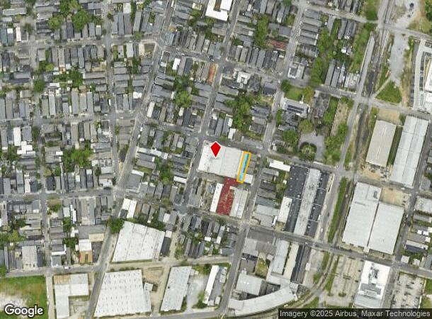
2726 Royal St, New Orleans, LA 70117

NEARBY LISTINGS FOR SALE OR LEASE
Property Detail
2726 Royal St
New Orleans-Metairie, LA
Faubourg Marigny 9
3-9W-1-069-11
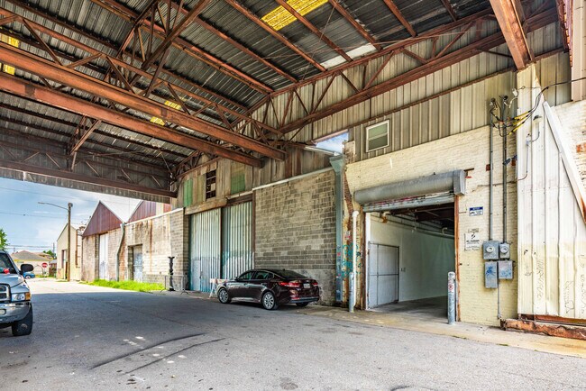
SQ 145 LOT 13 OR 9 ROYAL 26 X 138 1/STORY STEEL FRAME INDUSTRIAL; 2726 ROYAL ST., APTS. A & B
Miscresidentialimprovement
Orleans
X
Louisiana
22051C0225F
13
2024
0.08 AC
2025
Marigny/Bywater
001200
New Orleans/Metairie/Kenner
7,528 SF
DEMOGRAPHICS near 2726 Royal St
1 Mile
3 Mile
5 Mile
2024 Total Population
21,461
138,949
336,673
2029 Population
21,136
135,590
325,563
Pop Growth 2024-2029
(1.51%)
(2.42%)
(3.30%)
Average Age
45
41
40
2024 Total Households
11,761
66,993
147,329
HH Growth 2024-2029
(1.57%)
(2.30%)
(3.34%)
Median Household Inc
$50,856
$39,925
$47,965
Avg Household Size
1.80
2.00
2.10
2024 Avg HH Vehicles
1.00
1.00
1.00
Median Home Value
$374,438
$270,088
$281,735
Median Year Built
1946
1949
1955
Nearby Places
Map Layers
Map Styles
 Street
 Aerial
- Restaurants
- Banks
- Shops
- Fitness
- Groceries
PUBLIC TRANSPORTATION
TRANSIT/SUBWAY
Esplanade Avenue Station (Canal-Cemeteries Streetcar - New Orleans Regional Transit Authority Streetcars (New Orleans Streetcars), Canal-Museum Streetcar - New Orleans Regional Transit Authority Streetcars (New Orleans Streetcars), Riverfront Streetcar - New Orleans Regional Transit Authority Streetcars (New Orleans Streetcars))
DRIVE
WALK
Distance
Esplanade Avenue Station (Canal-Cemeteries Streetcar - New Orleans Regional Transit Authority Streetcars (New Orleans Streetcars), Canal-Museum Streetcar - New Orleans Regional Transit Authority Streetcars (New Orleans Streetcars), Riverfront Streetcar - New Orleans Regional Transit Authority Streetcars (New Orleans Streetcars))
4 min
10 min
0.5 mi
St. Claude Ave. At Elysian Fields (Rampart-Loyola Streetcar - NORTA)
DRIVE
WALK
Distance
St. Claude Ave. At Elysian Fields (Rampart-Loyola Streetcar - NORTA)
2 min
13 min
0.7 mi
Ursulines Street Station (Canal-Cemeteries Streetcar - New Orleans Regional Transit Authority Streetcars (New Orleans Streetcars), Canal-Museum Streetcar - New Orleans Regional Transit Authority Streetcars (New Orleans Streetcars), Riverfront Streetcar - New Orleans Regional Transit Authority Streetcars (New Orleans Streetcars))
DRIVE
WALK
Distance
Ursulines Street Station (Canal-Cemeteries Streetcar - New Orleans Regional Transit Authority Streetcars (New Orleans Streetcars), Canal-Museum Streetcar - New Orleans Regional Transit Authority Streetcars (New Orleans Streetcars), Riverfront Streetcar - New Orleans Regional Transit Authority Streetcars (New Orleans Streetcars))
6 min
14 min
0.7 mi
Ursulines Station (UPT-Riverfront - NORTA)
DRIVE
WALK
Distance
Ursulines Station (UPT-Riverfront - NORTA)
6 min
14 min
0.7 mi
St. Claude Ave. At Pauger St. (Rampart-Loyola Streetcar - NORTA)
DRIVE
WALK
Distance
St. Claude Ave. At Pauger St. (Rampart-Loyola Streetcar - NORTA)
2 min
16 min
0.8 mi
COMMUTER RAIL
New Orleans Union Passenger Terminal (City of New Orleans - Amtrak, Crescent - Amtrak, Sunset Limited - Amtrak)
DRIVE
WALK
Distance
New Orleans Union Passenger Terminal (City of New Orleans - Amtrak, Crescent - Amtrak, Sunset Limited - Amtrak)
7 min
2.8 mi
AIRPORT
Louis Armstrong New Orleans International
DRIVE
WALK
Distance
Louis Armstrong New Orleans International
25 min
16.1 mi
Freight Ports
Port of New Orleans
DRIVE
WALK
Distance
Port of New Orleans
15 min
6.3 mi
SALE & LEASE HISTORY
LISTING DATE
SALE/LEASE

Oct 30, 2020
For Lease
Mar 17, 2020
For Lease
Jul 17, 2024
For Lease
Jul 14, 2025
For Lease
Jan 09, 2017
For Lease
Apr 18, 2022
For Lease
Nearby Properties
Address
Land Use
TOTAL SIZE
Lot Size
Zoning
Address
Land Use
TOTAL SIZE
Lot Size
Zoning
Address
Land Use
TOTAL SIZE
Lot Size
Zoning
300 SF
2.19 AC
LS
Address
Land Use
TOTAL SIZE
Lot Size
Zoning
85,052 SF
2.19 AC
LS
Address
Land Use
TOTAL SIZE
Lot Size
Zoning
44.43 AC
CBD-4
Address
Land Use
TOTAL SIZE
Lot Size
Zoning
66.23 AC
CBD-4
Address
Land Use
TOTAL SIZE
Lot Size
Zoning
834,043 SF
1.40 AC
CBD-2
Address
Land Use
TOTAL SIZE
Lot Size
Zoning
18.31 AC
CBD-4
Address
Land Use
TOTAL SIZE
Lot Size
Zoning
1.87 AC
CBD-2
Address
Land Use
TOTAL SIZE
Lot Size
Zoning
6.64 AC
Address
Land Use
TOTAL SIZE
Lot Size
Zoning
844,362 SF
5.85 AC
CBD-4
Address
Land Use
TOTAL SIZE
Lot Size
Zoning
0.12 AC
Address
Land Use
TOTAL SIZE
Lot Size
Zoning
30.63 AC
Address
Land Use
TOTAL SIZE
Lot Size
Zoning
444,121 SF
1.46 AC
CBD-1
Address
Land Use
TOTAL SIZE
Lot Size
Zoning
0.88 AC
CBD-2
Address
Land Use
TOTAL SIZE
Lot Size
Zoning
22.17 AC
Address
Land Use
TOTAL SIZE
Lot Size
Zoning
1.91 AC
CBD-1
Address
Land Use
TOTAL SIZE
Lot Size
Zoning
576,962 SF
3.31 AC
CBD-4
Address
Land Use
TOTAL SIZE
Lot Size
Zoning
1.79 AC
Address
Land Use
TOTAL SIZE
Lot Size
Zoning
512,729 SF
6.60 AC
Address
Land Use
TOTAL SIZE
Lot Size
Zoning
1.24 AC
CBD-1
Address
Land Use
TOTAL SIZE
Lot Size
Zoning
190,708 SF
1.09 AC
CBD-2
Address
Land Use
TOTAL SIZE
Lot Size
Zoning
499,287 SF
1.44 AC
VCE
Address
Land Use
TOTAL SIZE
Lot Size
Zoning
0.67 AC
CBD-3
Address
Land Use
TOTAL SIZE
Lot Size
Zoning
202,291 SF
4.04 AC
HU-RD2
Address
Land Use
TOTAL SIZE
Lot Size
Zoning
162,382 SF
1.25 AC
CBD-2
Address
Land Use
TOTAL SIZE
Lot Size
Zoning
258,024 SF
0.63 AC
CBD-2
Address
Land Use
TOTAL SIZE
Lot Size
Zoning
2.94 AC
CBD-1
Address
Land Use
TOTAL SIZE
Lot Size
Zoning
462,672 SF
1.11 AC
CBD-1
Address
Land Use
TOTAL SIZE
Lot Size
Zoning
1.84 AC
CBD-7
Address
Land Use
TOTAL SIZE
Lot Size
Zoning
224,374 SF
92.67 AC
HU-RD1
The World's #1 Commercial Real Estate Marketplace
Connect with us
© 2025 CoStar Group
The information above has been obtained from sources believed reliable. While we do not doubt its accuracy we have not verified it and make no guarantee, warranty or representation about it. It is your responsibility to independently confirm its accuracy and completeness. Any projections, opinions, assumptions, or estimates used are for example only and do not represent the current or future performance of the property. The value of this transaction to you depends on tax and other factors which should be evaluated by your tax, financial, and legal advisors. You and your advisors should conduct a careful, independent investigation of the property to determine to your satisfaction the suitability of the property for your needs.