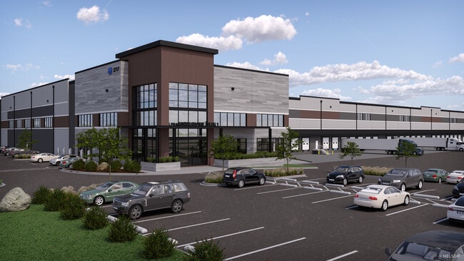
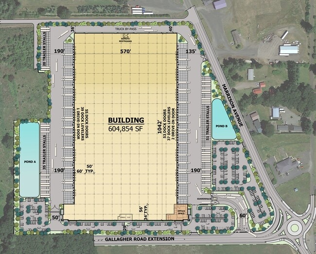
Property Record
2727 Harrison Ave, Centralia, WA 98531
Current Lease Availabilities
NEARBY LISTINGS FOR SALE OR LEASE
Property Detail
2727 Harrison Ave
Centralia, WA
SECTION 36 TOWNSHIP 15N RANGE 03W 540X241.4 TR PT WLY 540 E 608.7 WIFES 1/2 SS FORD DLC PT SW4 NE4 FR
024006-016-001
Lewis
Multifamilydwelling
Washington
0
34.11 AC
2025
Washington State Area
970500
Other Market Areas
12,844 SF
DEMOGRAPHICS near 2727 Harrison Ave
1 mile
3 mile
5 mile
2024 Total Population
2,159
20,578
33,180
2029 Population
2,454
23,530
37,551
Pop Growth 2024-2029
+ 13.66%
+ 14.35%
+ 13.17%
Average Age
42
41
40
2024 Total Households
878
8,015
12,538
HH Growth 2024-2029
+ 13.78%
+ 14.47%
+ 13.38%
Median Household Inc
$31,574
$58,442
$64,764
Avg Household Size
2.40
2.50
2.50
2024 Avg HH Vehicles
2.00
2.00
2.00
Median Home Value
$323,670
$341,331
$359,000
Median Year Built
1981
1980
1981
Nearby Places
Map Layers
Map Styles
 Street
 Aerial
Transit
 Traffic
 Biking
Places
Listings with unknown addresses are not visible on the map
- Restaurants
- Banks
- Shops
- Fitness
- Groceries
PUBLIC TRANSPORTATION
COMMUTER RAIL
Centralia Amtrak Station (Amtrak Cascades - Amtrak, Coast Starlight - Amtrak)
Drive
Walk
Distance
Centralia Amtrak Station (Amtrak Cascades - Amtrak, Coast Starlight - Amtrak)
9 min
3.5 mi
Freight Ports
Port of Grays Harbor, WA
Drive
Walk
Distance
Port of Grays Harbor, WA
80 min
52.1 mi
Nearby Properties
Address
Land Use
TOTAL SIZE
Lot Size
Zoning
Address
Land Use
TOTAL SIZE
Lot Size
Zoning
1,038,447 SF
77 AC
PMP
Address
Land Use
TOTAL SIZE
Lot Size
Zoning
441,608 SF
Address
Land Use
TOTAL SIZE
Lot Size
Zoning
32,914 SF
3.38 AC
PMP
Address
Land Use
TOTAL SIZE
Lot Size
Zoning
155,458 SF
15.79 AC
PMP
Address
Land Use
TOTAL SIZE
Lot Size
Zoning
2,003 SF
27.85 AC
LBD
Address
Land Use
TOTAL SIZE
Lot Size
Zoning
738,962 SF
16.50 AC
Address
Land Use
TOTAL SIZE
Lot Size
Zoning
1,427 SF
15.22 AC
Address
Land Use
TOTAL SIZE
Lot Size
Zoning
129,242 SF
11.91 AC
M1
Address
Land Use
TOTAL SIZE
Lot Size
Zoning
1,792 SF
38.78 AC
OSPF
Address
Land Use
TOTAL SIZE
Lot Size
Zoning
1,696 SF
12.45 AC
PMP
Address
Land Use
TOTAL SIZE
Lot Size
Zoning
142,368 SF
6.60 AC
R20
Address
Land Use
TOTAL SIZE
Lot Size
Zoning
2,956 SF
4.99 AC
R15
Address
Land Use
TOTAL SIZE
Lot Size
Zoning
64,421 SF
5 AC
H1
Address
Land Use
TOTAL SIZE
Lot Size
Zoning
196,060 SF
24.68 AC
PMP
Address
Land Use
TOTAL SIZE
Lot Size
Zoning
Address
Land Use
TOTAL SIZE
Lot Size
Zoning
57,621 SF
5.33 AC
H1
Address
Land Use
TOTAL SIZE
Lot Size
Zoning
2.14 AC
C1
Address
Land Use
TOTAL SIZE
Lot Size
Zoning
7,200 SF
4 AC
OSPF
Address
Land Use
TOTAL SIZE
Lot Size
Zoning
28,522 SF
2 AC
M2
Address
Land Use
TOTAL SIZE
Lot Size
Zoning
29,204 SF
3.91 AC
R20
Address
Land Use
TOTAL SIZE
Lot Size
Zoning
75,993 SF
18.76 AC
PMP
Address
Land Use
TOTAL SIZE
Lot Size
Zoning
Address
Land Use
TOTAL SIZE
Lot Size
Zoning
3,196 SF
4.48 AC
R15
Address
Land Use
TOTAL SIZE
Lot Size
Zoning
48,865 SF
4.70 AC
H1
Address
Land Use
TOTAL SIZE
Lot Size
Zoning
104,872 SF
Address
Land Use
TOTAL SIZE
Lot Size
Zoning
3,536 SF
1.73 AC
R20
Address
Land Use
TOTAL SIZE
Lot Size
Zoning
1,512 SF
8.64 AC
OSPF
Address
Land Use
TOTAL SIZE
Lot Size
Zoning
21,672 SF
2.08 AC
R20
Address
Land Use
TOTAL SIZE
Lot Size
Zoning
34,408 SF
3.58 AC
C1
Address
Land Use
TOTAL SIZE
Lot Size
Zoning
940 SF
1.50 AC
The World's #1 Commercial Real Estate Marketplace
Connect with us
© 2026 CoStar Group
The information above has been obtained from sources believed reliable. While we do not doubt its accuracy we have not verified it and make no guarantee, warranty or representation about it. It is your responsibility to independently confirm its accuracy and completeness. Any projections, opinions, assumptions, or estimates used are for example only and do not represent the current or future performance of the property. The value of this transaction to you depends on tax and other factors which should be evaluated by your tax, financial, and legal advisors. You and your advisors should conduct a careful, independent investigation of the property to determine to your satisfaction the suitability of the property for your needs.