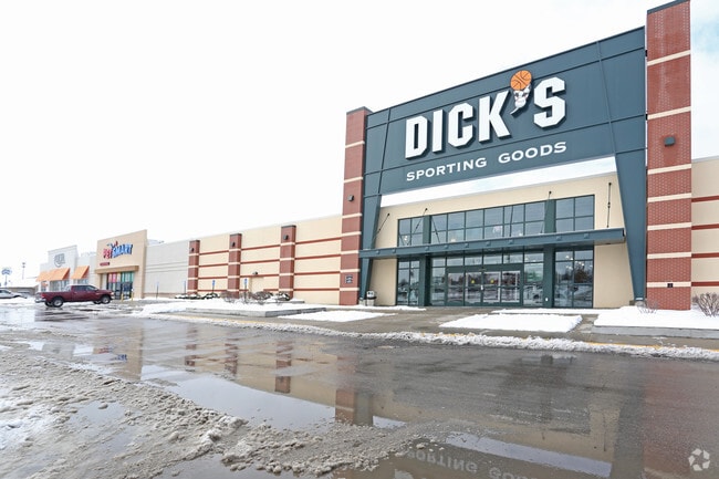
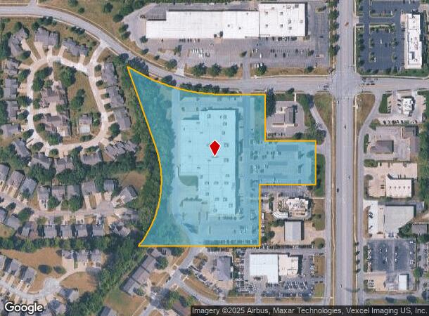
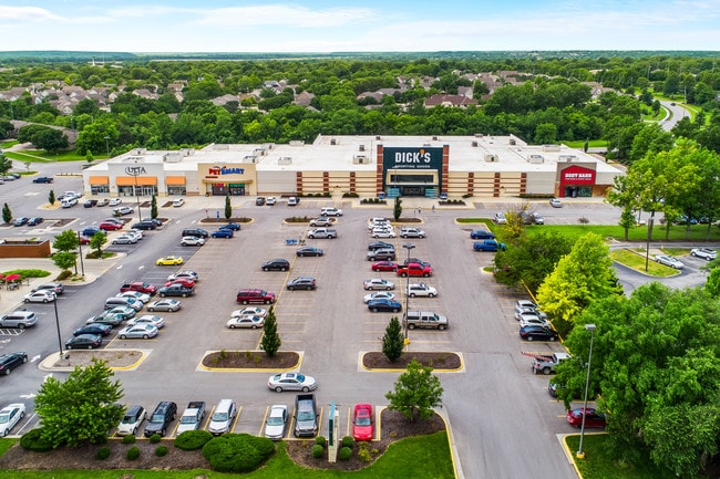
Property Record
2727 Iowa St, Lawrence, KS 66046

NEARBY LISTINGS FOR SALE OR LEASE
Property Detail
2727 Iowa St
Lawrence, KS
27 Iowa Addition
023-111-11-0-40-02-002.00-0
27 IOWA ADD LT 1 (REPLAT 2015)
Storebuilding
Douglas
AE
Kansas
20045C0167D
1
2025
8.47 AC
2025
Lawrence
000802
Kansas City
86,199 SF
DEMOGRAPHICS near 2727 Iowa St
1 Mile
3 Mile
5 Mile
2024 Total Population
12,635
68,061
99,747
2029 Population
12,947
69,412
101,802
Pop Growth 2024-2029
+ 2.47%
+ 1.98%
+ 2.06%
Average Age
34
34
36
2024 Total Households
5,687
27,934
41,676
HH Growth 2024-2029
+ 2.62%
+ 2.18%
+ 2.23%
Median Household Inc
$41,168
$49,377
$55,297
Avg Household Size
2.20
2.10
2.20
2024 Avg HH Vehicles
2.00
2.00
2.00
Median Home Value
$192,035
$219,505
$241,318
Median Year Built
1983
1981
1988
Nearby Places
Map Layers
Map Styles
 Street
 Aerial
- Restaurants
- Banks
- Shops
- Fitness
- Groceries
PUBLIC TRANSPORTATION
COMMUTER RAIL
DRIVE
WALK
Distance
10 min
4.6 mi
SALE & LEASE HISTORY
LISTING DATE
SALE/LEASE

Sep 25, 2016
For Lease
Aug 16, 2019
For Sale
Nearby Properties
Address
Land Use
TOTAL SIZE
Lot Size
Zoning
Address
Land Use
TOTAL SIZE
Lot Size
Zoning
1,709,524 SF
32.03 AC
RD
Address
Land Use
TOTAL SIZE
Lot Size
Zoning
1,258,819 SF
106.65 AC
RD
Address
Land Use
TOTAL SIZE
Lot Size
Zoning
1,264,810 SF
129.10 AC
RD
Address
Land Use
TOTAL SIZE
Lot Size
Zoning
632,738 SF
292.10 AC
RS2
Address
Land Use
TOTAL SIZE
Lot Size
Zoning
335,349 SF
3.17 AC
RD
Address
Land Use
TOTAL SIZE
Lot Size
Zoning
112,168 SF
38.08 AC
RD
Address
Land Use
TOTAL SIZE
Lot Size
Zoning
200,960 SF
9.20 AC
RD
Address
Land Use
TOTAL SIZE
Lot Size
Zoning
249,773 SF
34.84 AC
RS2
Address
Land Use
TOTAL SIZE
Lot Size
Zoning
336,701 SF
5.20 AC
RD
Address
Land Use
TOTAL SIZE
Lot Size
Zoning
47,457 SF
2.58 AC
Address
Land Use
TOTAL SIZE
Lot Size
Zoning
220,557 SF
8.90 AC
RD
Address
Land Use
TOTAL SIZE
Lot Size
Zoning
162,086 SF
3 AC
RD
Address
Land Use
TOTAL SIZE
Lot Size
Zoning
143,279 SF
36.20 AC
RS1
Address
Land Use
TOTAL SIZE
Lot Size
Zoning
67,500 SF
4.03 AC
RM1
Address
Land Use
TOTAL SIZE
Lot Size
Zoning
181,346 SF
21.40 AC
497
Address
Land Use
TOTAL SIZE
Lot Size
Zoning
186,889 SF
3.60 AC
RD
Address
Land Use
TOTAL SIZE
Lot Size
Zoning
92,295 SF
10.40 AC
RS1
Address
Land Use
TOTAL SIZE
Lot Size
Zoning
143,467 SF
2.80 AC
RM1
Address
Land Use
TOTAL SIZE
Lot Size
Zoning
11,992 SF
118.15 AC
RS1
Address
Land Use
TOTAL SIZE
Lot Size
Zoning
125,214 SF
20 AC
RS1
Address
Land Use
TOTAL SIZE
Lot Size
Zoning
104,785 SF
105.60 AC
RS1
Address
Land Use
TOTAL SIZE
Lot Size
Zoning
1,034 SF
254.80 AC
AG
Address
Land Use
TOTAL SIZE
Lot Size
Zoning
78,051 SF
37.20 AC
RS2
Address
Land Use
TOTAL SIZE
Lot Size
Zoning
92,819 SF
3.10 AC
RO2
Address
Land Use
TOTAL SIZE
Lot Size
Zoning
52,000 SF
36 AC
RS1
Address
Land Use
TOTAL SIZE
Lot Size
Zoning
19,985 SF
103.37 AC
RS1
Address
Land Use
TOTAL SIZE
Lot Size
Zoning
337,280 SF
0.60 AC
RD
Address
Land Use
TOTAL SIZE
Lot Size
Zoning
52,028 SF
11.07 AC
Address
Land Use
TOTAL SIZE
Lot Size
Zoning
31,750 SF
0.73 AC
Address
Land Use
TOTAL SIZE
Lot Size
Zoning
34,479 SF
1.08 AC
C4
The World's #1 Commercial Real Estate Marketplace
Connect with us
© 2026 CoStar Group
The information above has been obtained from sources believed reliable. While we do not doubt its accuracy we have not verified it and make no guarantee, warranty or representation about it. It is your responsibility to independently confirm its accuracy and completeness. Any projections, opinions, assumptions, or estimates used are for example only and do not represent the current or future performance of the property. The value of this transaction to you depends on tax and other factors which should be evaluated by your tax, financial, and legal advisors. You and your advisors should conduct a careful, independent investigation of the property to determine to your satisfaction the suitability of the property for your needs.