Property Record
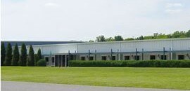
2727 Kentronics Dr, Owensboro, KY 42301

NEARBY LISTINGS FOR SALE OR LEASE
-
-
View all Owensboro listings for lease on LoopNet.com
Property Detail
2727 Kentronics Dr
046-00-00-020-00-000
46-202727 KENTRONICS DR16.30 ACRES
Commercialnec
Daviess
X
Kentucky
21059C0117E
16.30 AC
2025
Kentucky West Area
2025
Other Market Areas
001300
Owensboro, KY
235,840 SF
DEMOGRAPHICS near 2727 Kentronics Dr
1 Mile
3 Mile
5 Mile
2024 Total Population
2,945
28,368
63,538
2029 Population
2,889
28,431
63,708
Pop Growth 2024-2029
(1.90%)
+ 0.22%
+ 0.27%
Average Age
38
40
40
2024 Total Households
1,221
11,665
26,270
HH Growth 2024-2029
(1.97%)
+ 0.28%
+ 0.30%
Median Household Inc
$45,392
$47,626
$51,676
Avg Household Size
2.40
2.30
2.30
2024 Avg HH Vehicles
2.00
2.00
2.00
Median Home Value
$125,338
$140,987
$146,420
Median Year Built
1979
1968
1971
Nearby Places
Map Layers
Map Styles
 Street
 Aerial
- Restaurants
- Banks
- Shops
- Fitness
- Groceries
PUBLIC TRANSPORTATION
AIRPORT
Evansville Regional
DRIVE
WALK
Distance
Evansville Regional
57 min
39.8 mi
Freight Ports
Port of Toledo
DRIVE
WALK
Distance
Port of Toledo
480 min
414.3 mi
SALE & LEASE HISTORY
LISTING DATE
SALE/LEASE

Sep 25, 2016
For Lease
Mar 07, 2018
For Lease
Jan 12, 2018
For Lease
Nearby Properties
Address
Land Use
TOTAL SIZE
Lot Size
Zoning
Address
Land Use
TOTAL SIZE
Lot Size
Zoning
169,482 SF
10.21 AC
Address
Land Use
TOTAL SIZE
Lot Size
Zoning
3,610 SF
1.23 AC
Address
Land Use
TOTAL SIZE
Lot Size
Zoning
450,235 SF
24.61 AC
Address
Land Use
TOTAL SIZE
Lot Size
Zoning
184,854 SF
9.46 AC
Address
Land Use
TOTAL SIZE
Lot Size
Zoning
88,745 SF
2.62 AC
Address
Land Use
TOTAL SIZE
Lot Size
Zoning
454,200 SF
44.55 AC
Address
Land Use
TOTAL SIZE
Lot Size
Zoning
46,184 SF
1.99 AC
Address
Land Use
TOTAL SIZE
Lot Size
Zoning
113,025 SF
2.10 AC
Address
Land Use
TOTAL SIZE
Lot Size
Zoning
62,312 SF
0.88 AC
Address
Land Use
TOTAL SIZE
Lot Size
Zoning
215,439 SF
15.02 AC
Address
Land Use
TOTAL SIZE
Lot Size
Zoning
82,027 SF
2.40 AC
Address
Land Use
TOTAL SIZE
Lot Size
Zoning
38,052 SF
11.46 AC
Address
Land Use
TOTAL SIZE
Lot Size
Zoning
180 SF
122.13 AC
Address
Land Use
TOTAL SIZE
Lot Size
Zoning
53,280 SF
Address
Land Use
TOTAL SIZE
Lot Size
Zoning
280 SF
2.60 AC
Address
Land Use
TOTAL SIZE
Lot Size
Zoning
45,860 SF
13.88 AC
Address
Land Use
TOTAL SIZE
Lot Size
Zoning
69,884 SF
61.31 AC
Address
Land Use
TOTAL SIZE
Lot Size
Zoning
340,000 SF
33.62 AC
Address
Land Use
TOTAL SIZE
Lot Size
Zoning
155,700 SF
7.78 AC
Address
Land Use
TOTAL SIZE
Lot Size
Zoning
51,232 SF
1.40 AC
Address
Land Use
TOTAL SIZE
Lot Size
Zoning
1,980 SF
303.90 AC
Address
Land Use
TOTAL SIZE
Lot Size
Zoning
92,159 SF
2.08 AC
Address
Land Use
TOTAL SIZE
Lot Size
Zoning
58,060 SF
2.07 AC
Address
Land Use
TOTAL SIZE
Lot Size
Zoning
109,630 SF
1.02 AC
Address
Land Use
TOTAL SIZE
Lot Size
Zoning
4,160 SF
1.26 AC
Address
Land Use
TOTAL SIZE
Lot Size
Zoning
44,887 SF
4.31 AC
Address
Land Use
TOTAL SIZE
Lot Size
Zoning
68,250 SF
1.30 AC
Address
Land Use
TOTAL SIZE
Lot Size
Zoning
20,024 SF
8.02 AC
Address
Land Use
TOTAL SIZE
Lot Size
Zoning
30,710 SF
2 AC
Address
Land Use
TOTAL SIZE
Lot Size
Zoning
46,844 SF
2.72 AC
The World's #1 Commercial Real Estate Marketplace
Connect with us
© 2025 CoStar Group
The information above has been obtained from sources believed reliable. While we do not doubt its accuracy we have not verified it and make no guarantee, warranty or representation about it. It is your responsibility to independently confirm its accuracy and completeness. Any projections, opinions, assumptions, or estimates used are for example only and do not represent the current or future performance of the property. The value of this transaction to you depends on tax and other factors which should be evaluated by your tax, financial, and legal advisors. You and your advisors should conduct a careful, independent investigation of the property to determine to your satisfaction the suitability of the property for your needs.