Property Record
2727 N Poplar St, Casper, WY 82601

NEARBY LISTINGS FOR SALE OR LEASE
Property Detail
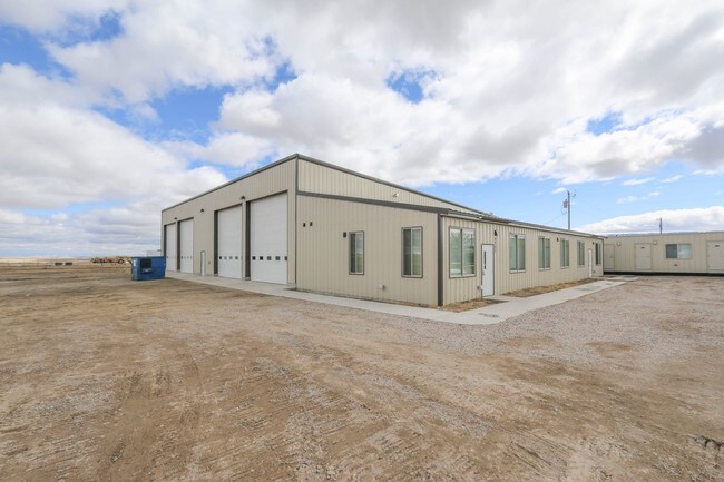
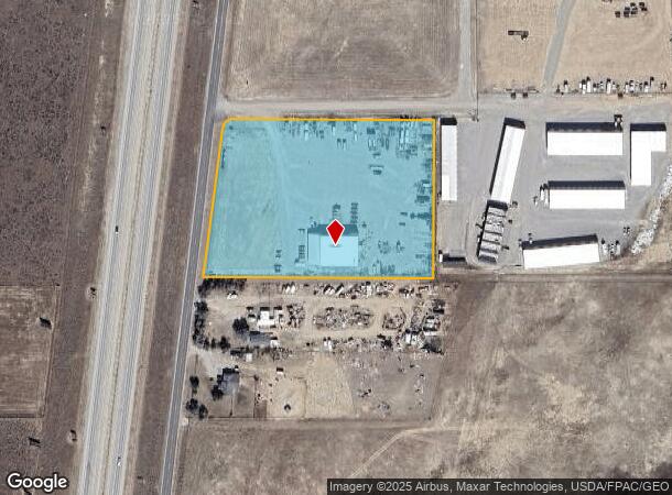
2727 N Poplar St
Casper, WY
Fullspeed (Rplt Fullspeed Simple)
34-79-29-1-0-100700
FULLSPEED (RPLT FULLSPEED SIMPLE) LOT TR 5
Warehouse
Natrona
D
Wyoming
56025C1700D
tr5
2024
5.45 AC
2025
I-25 Corridor/Casper
001401
Other Market Areas
10,400 SF
DEMOGRAPHICS near 2727 N Poplar St
1 Mile
3 Mile
5 Mile
2024 Total Population
782
8,979
50,311
2029 Population
810
9,218
51,124
Pop Growth 2024-2029
+ 3.58%
+ 2.66%
+ 1.62%
Average Age
40
39
40
2024 Total Households
294
3,867
21,480
HH Growth 2024-2029
+ 3.74%
+ 2.84%
+ 1.65%
Median Household Inc
$64,500
$47,089
$58,364
Avg Household Size
2.70
2.30
2.30
2024 Avg HH Vehicles
3.00
2.00
2.00
Median Home Value
$220,454
$200,510
$203,550
Median Year Built
1995
1979
1970
Nearby Places
Map Layers
Map Styles
 Street
 Aerial
- Restaurants
- Banks
- Shops
- Fitness
- Groceries
PUBLIC TRANSPORTATION
AIRPORT
Casper/Natrona County International
DRIVE
WALK
Distance
Casper/Natrona County International
27 min
14.7 mi
Freight Ports
Tulsa Port Of Catoosa
DRIVE
WALK
Distance
Tulsa Port Of Catoosa
996 min
980.4 mi
SALE & LEASE HISTORY
LISTING DATE
SALE/LEASE

Apr 04, 2019
For Sale
Apr 04, 2019
For Sale
Nearby Properties
Address
Land Use
TOTAL SIZE
Lot Size
Zoning
Address
Land Use
TOTAL SIZE
Lot Size
Zoning
156,457 SF
5.74 AC
Address
Land Use
TOTAL SIZE
Lot Size
Zoning
95,290 SF
0.57 AC
Address
Land Use
TOTAL SIZE
Lot Size
Zoning
99,524 SF
4.67 AC
Address
Land Use
TOTAL SIZE
Lot Size
Zoning
81,240 SF
5.86 AC
Address
Land Use
TOTAL SIZE
Lot Size
Zoning
166,099 SF
7.65 AC
Address
Land Use
TOTAL SIZE
Lot Size
Zoning
89,892 SF
2.75 AC
Address
Land Use
TOTAL SIZE
Lot Size
Zoning
88,739 SF
13.39 AC
Address
Land Use
TOTAL SIZE
Lot Size
Zoning
54,112 SF
3.52 AC
Address
Land Use
TOTAL SIZE
Lot Size
Zoning
21,120 SF
16.73 AC
Address
Land Use
TOTAL SIZE
Lot Size
Zoning
76,420 SF
6.67 AC
Address
Land Use
TOTAL SIZE
Lot Size
Zoning
82,800 SF
5.94 AC
Address
Land Use
TOTAL SIZE
Lot Size
Zoning
56,433 SF
3 AC
Address
Land Use
TOTAL SIZE
Lot Size
Zoning
45,297 SF
1.29 AC
Address
Land Use
TOTAL SIZE
Lot Size
Zoning
65,427 SF
2.16 AC
Address
Land Use
TOTAL SIZE
Lot Size
Zoning
95,322 SF
2.01 AC
Address
Land Use
TOTAL SIZE
Lot Size
Zoning
63,950 SF
8.02 AC
Address
Land Use
TOTAL SIZE
Lot Size
Zoning
58,661 SF
2.49 AC
Address
Land Use
TOTAL SIZE
Lot Size
Zoning
55,953 SF
1.94 AC
Address
Land Use
TOTAL SIZE
Lot Size
Zoning
22,150 SF
5.49 AC
Address
Land Use
TOTAL SIZE
Lot Size
Zoning
19,695 SF
2.40 AC
Address
Land Use
TOTAL SIZE
Lot Size
Zoning
17,181 SF
0.38 AC
Address
Land Use
TOTAL SIZE
Lot Size
Zoning
84,524 SF
3.46 AC
Address
Land Use
TOTAL SIZE
Lot Size
Zoning
39,061 SF
3.61 AC
Address
Land Use
TOTAL SIZE
Lot Size
Zoning
63,811 SF
12.23 AC
Address
Land Use
TOTAL SIZE
Lot Size
Zoning
59,690 SF
14.68 AC
Address
Land Use
TOTAL SIZE
Lot Size
Zoning
23,040 SF
7.92 AC
Address
Land Use
TOTAL SIZE
Lot Size
Zoning
42,988 SF
13.68 AC
Address
Land Use
TOTAL SIZE
Lot Size
Zoning
20,883 SF
0.77 AC
Address
Land Use
TOTAL SIZE
Lot Size
Zoning
25,410 SF
10.96 AC
Address
Land Use
TOTAL SIZE
Lot Size
Zoning
8,288 SF
3.50 AC
The World's #1 Commercial Real Estate Marketplace
Connect with us
© 2025 CoStar Group
The information above has been obtained from sources believed reliable. While we do not doubt its accuracy we have not verified it and make no guarantee, warranty or representation about it. It is your responsibility to independently confirm its accuracy and completeness. Any projections, opinions, assumptions, or estimates used are for example only and do not represent the current or future performance of the property. The value of this transaction to you depends on tax and other factors which should be evaluated by your tax, financial, and legal advisors. You and your advisors should conduct a careful, independent investigation of the property to determine to your satisfaction the suitability of the property for your needs.