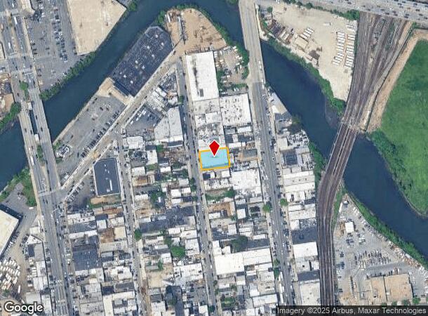
Property Record
2727 W 15Th St, Brooklyn, NY 11224
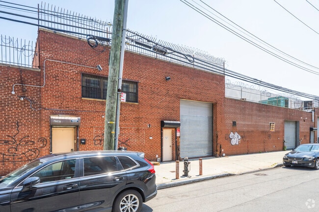
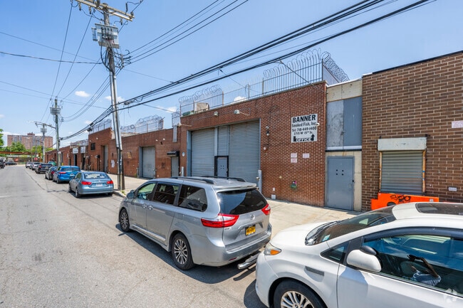
This Property Is For Sale
NEARBY LISTINGS FOR SALE OR LEASE
Property Detail
2727 W 15Th St
06997-0038
DOCID-2020031801233002
Warehouse
Kings
AE
New York
3604970353F
38
2024
0.22 AC
2025
South Brooklyn
032600
Long Island (New York)
8,815 SF
New York-Jersey City-White Plains, NY-NJ
DEMOGRAPHICS near 2727 W 15Th St
1 mile
3 mile
5 mile
2024 Total Population
77,681
476,466
1,108,393
2029 Population
74,061
442,611
1,025,806
Pop Growth 2024-2029
(4.66%)
(7.11%)
(7.45%)
Average Age
46
42
40
2024 Total Households
31,087
171,227
381,381
HH Growth 2024-2029
(5.07%)
(7.53%)
(7.77%)
Median Household Inc
$41,887
$58,928
$65,485
Avg Household Size
2.40
2.70
2.80
2024 Avg HH Vehicles
1.00
1.00
1.00
Median Home Value
$533,087
$788,388
$791,507
Median Year Built
1963
1949
1948
Nearby Places
Map Layers
Map Styles
 Street
 Aerial
Transit
 Traffic
 Biking
Places
Listings with unknown addresses are not visible on the map
- Restaurants
- Banks
- Shops
- Fitness
- Groceries
PUBLIC TRANSPORTATION
TRANSIT/SUBWAY
Coney Island-Stillwell Avenue (D - New York MTA Subway (The Subway), F - New York MTA Subway (The Subway), N - New York MTA Subway (The Subway), Q - New York MTA Subway (The Subway))
Drive
Walk
Distance
Coney Island-Stillwell Avenue (D - New York MTA Subway (The Subway), F - New York MTA Subway (The Subway), N - New York MTA Subway (The Subway), Q - New York MTA Subway (The Subway))
2 min
7 min
0.4 mi
Neptune Avenue (F - New York MTA Subway (The Subway))
Drive
Walk
Distance
Neptune Avenue (F - New York MTA Subway (The Subway))
4 min
13 min
0.6 mi
West 8 Street-New York Aquarium (F - New York MTA Subway (The Subway), Q - New York MTA Subway (The Subway))
Drive
Walk
Distance
West 8 Street-New York Aquarium (F - New York MTA Subway (The Subway), Q - New York MTA Subway (The Subway))
6 min
15 min
0.8 mi
Bay 50 Street (D - New York MTA Subway (The Subway))
Drive
Walk
Distance
Bay 50 Street (D - New York MTA Subway (The Subway))
3 min
15 min
0.8 mi
COMMUTER RAIL
Grasmere (Staten Island Railway - New York MTA Subway (The Subway))
Drive
Walk
Distance
Grasmere (Staten Island Railway - New York MTA Subway (The Subway))
16 min
7.8 mi
Old Town (Staten Island Railway - New York MTA Subway (The Subway))
Drive
Walk
Distance
Old Town (Staten Island Railway - New York MTA Subway (The Subway))
17 min
7.9 mi
AIRPORT
John F Kennedy International
Drive
Walk
Distance
John F Kennedy International
27 min
16.2 mi
LaGuardia
Drive
Walk
Distance
LaGuardia
37 min
21.7 mi
Newark Liberty International
Drive
Walk
Distance
Newark Liberty International
37 min
22.9 mi
Freight Ports
NY - Red Hook Container Terminal
Drive
Walk
Distance
NY - Red Hook Container Terminal
18 min
10.6 mi
Nearby Properties
Address
Land Use
TOTAL SIZE
Lot Size
Zoning
Address
Land Use
TOTAL SIZE
Lot Size
Zoning
1,524,659 SF
170.96 AC
R4
Address
Land Use
TOTAL SIZE
Lot Size
Zoning
1,078,317 SF
10.45 AC
R4
Address
Land Use
TOTAL SIZE
Lot Size
Zoning
5,800 SF
20.10 AC
R6
Address
Land Use
TOTAL SIZE
Lot Size
Zoning
5,800 SF
20.10 AC
R6
Address
Land Use
TOTAL SIZE
Lot Size
Zoning
5,800 SF
20.10 AC
R6
Address
Land Use
TOTAL SIZE
Lot Size
Zoning
5,800 SF
20.10 AC
R6
Address
Land Use
TOTAL SIZE
Lot Size
Zoning
5,800 SF
20.10 AC
R6
Address
Land Use
TOTAL SIZE
Lot Size
Zoning
5,800 SF
20.10 AC
R6
Address
Land Use
TOTAL SIZE
Lot Size
Zoning
5,800 SF
20.10 AC
R6
Address
Land Use
TOTAL SIZE
Lot Size
Zoning
5,800 SF
20.10 AC
R6
Address
Land Use
TOTAL SIZE
Lot Size
Zoning
5,800 SF
20.10 AC
R6
Address
Land Use
TOTAL SIZE
Lot Size
Zoning
12.39 AC
R6
Address
Land Use
TOTAL SIZE
Lot Size
Zoning
965,600 SF
6.65 AC
R5
Address
Land Use
TOTAL SIZE
Lot Size
Zoning
54.78 AC
PARK
Address
Land Use
TOTAL SIZE
Lot Size
Zoning
353,600 SF
55.79 AC
R3-1
Address
Land Use
TOTAL SIZE
Lot Size
Zoning
1,800,000 SF
12.39 AC
R6
Address
Land Use
TOTAL SIZE
Lot Size
Zoning
1,736,700 SF
20.10 AC
R6
Address
Land Use
TOTAL SIZE
Lot Size
Zoning
753,367 SF
5.11 AC
R6
Address
Land Use
TOTAL SIZE
Lot Size
Zoning
623,806 SF
4.68 AC
R6
Address
Land Use
TOTAL SIZE
Lot Size
Zoning
623,806 SF
4.68 AC
R6
Address
Land Use
TOTAL SIZE
Lot Size
Zoning
623,806 SF
4.68 AC
R6
Address
Land Use
TOTAL SIZE
Lot Size
Zoning
623,806 SF
4.68 AC
R6
Address
Land Use
TOTAL SIZE
Lot Size
Zoning
623,806 SF
4.68 AC
R6
Address
Land Use
TOTAL SIZE
Lot Size
Zoning
623,806 SF
4.68 AC
R6
Address
Land Use
TOTAL SIZE
Lot Size
Zoning
623,806 SF
4.68 AC
R6
Address
Land Use
TOTAL SIZE
Lot Size
Zoning
623,806 SF
4.68 AC
R6
Address
Land Use
TOTAL SIZE
Lot Size
Zoning
623,806 SF
4.68 AC
R6
Address
Land Use
TOTAL SIZE
Lot Size
Zoning
623,806 SF
4.68 AC
R6
Address
Land Use
TOTAL SIZE
Lot Size
Zoning
623,806 SF
4.68 AC
R6
Address
Land Use
TOTAL SIZE
Lot Size
Zoning
623,806 SF
4.68 AC
R6
The World's #1 Commercial Real Estate Marketplace
Connect with us
© 2026 CoStar Group
The information above has been obtained from sources believed reliable. While we do not doubt its accuracy we have not verified it and make no guarantee, warranty or representation about it. It is your responsibility to independently confirm its accuracy and completeness. Any projections, opinions, assumptions, or estimates used are for example only and do not represent the current or future performance of the property. The value of this transaction to you depends on tax and other factors which should be evaluated by your tax, financial, and legal advisors. You and your advisors should conduct a careful, independent investigation of the property to determine to your satisfaction the suitability of the property for your needs.