Property Record
2729 E Beersville Rd, Bath, PA 18014
NEARBY LISTINGS FOR SALE OR LEASE
-
-
View all Bath listings for sale on LoopNet.com
Property Detail
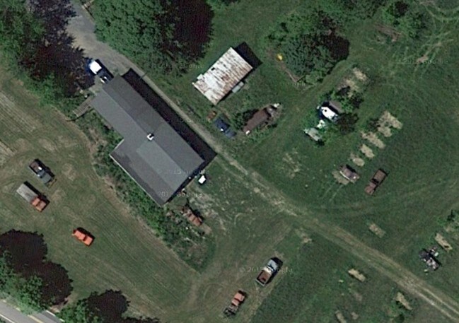
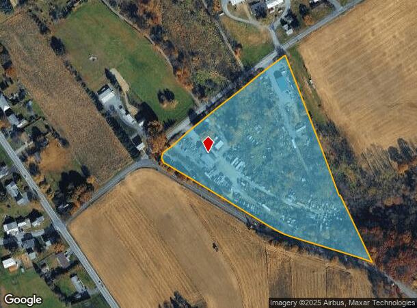
2729 E Beersville Rd
Storageyardjunkautowreckingsalvage
Northampton
X
Pennsylvania
42095C0120E
9.32 AC
2025
Lehigh Valley
2025
Philadelphia
015901
Allentown-Bethlehem-Easton, PA-NJ
1,267 SF
J5-6-4-0520
DEMOGRAPHICS near 2729 E Beersville Rd
1 Mile
3 Mile
5 Mile
2024 Total Population
1,235
12,362
29,873
2029 Population
1,238
12,462
30,155
Pop Growth 2024-2029
+ 0.24%
+ 0.81%
+ 0.94%
Average Age
46
45
45
2024 Total Households
498
4,732
10,670
HH Growth 2024-2029
+ 0.20%
+ 0.74%
+ 0.75%
Median Household Inc
$98,735
$81,157
$89,976
Avg Household Size
2.50
2.50
2.60
2024 Avg HH Vehicles
3.00
2.00
2.00
Median Home Value
$332,327
$281,826
$305,907
Median Year Built
1977
1978
1980
Nearby Places
- Restaurants
- Banks
- Shops
- Fitness
- Groceries
PUBLIC TRANSPORTATION
AIRPORT
Lehigh Valley International
DRIVE
WALK
Distance
Lehigh Valley International
18 min
9.8 mi
Freight Ports
Port of Philadelphia
DRIVE
WALK
Distance
Port of Philadelphia
102 min
75.7 mi
Nearby Properties
Address
Land Use
TOTAL SIZE
Lot Size
Zoning
Address
Land Use
TOTAL SIZE
Lot Size
Zoning
86,546 SF
17.75 AC
SR
Address
Land Use
TOTAL SIZE
Lot Size
Zoning
5,746 SF
89.51 AC
SR
Address
Land Use
TOTAL SIZE
Lot Size
Zoning
51,894 SF
2.46 AC
M2
Address
Land Use
TOTAL SIZE
Lot Size
Zoning
12,000 SF
6.19 AC
R2
Address
Land Use
TOTAL SIZE
Lot Size
Zoning
43,335 SF
2.43 AC
M2
Address
Land Use
TOTAL SIZE
Lot Size
Zoning
19,166 SF
15 AC
R
Address
Land Use
TOTAL SIZE
Lot Size
Zoning
25,104 SF
27 AC
R1
Address
Land Use
TOTAL SIZE
Lot Size
Zoning
9,894 SF
0.68 AC
RI
Address
Land Use
TOTAL SIZE
Lot Size
Zoning
38,438 SF
10.61 AC
I
Address
Land Use
TOTAL SIZE
Lot Size
Zoning
13,472 SF
6.64 AC
VC
Address
Land Use
TOTAL SIZE
Lot Size
Zoning
25,203 SF
1.65 AC
MI
Address
Land Use
TOTAL SIZE
Lot Size
Zoning
37,227 SF
6.02 AC
I
Address
Land Use
TOTAL SIZE
Lot Size
Zoning
36,700 SF
23.80 AC
R
Address
Land Use
TOTAL SIZE
Lot Size
Zoning
27,307 SF
0.89 AC
I
Address
Land Use
TOTAL SIZE
Lot Size
Zoning
16,862 SF
9 AC
R
Address
Land Use
TOTAL SIZE
Lot Size
Zoning
10,160 SF
4.40 AC
VC
Address
Land Use
TOTAL SIZE
Lot Size
Zoning
2,304 SF
57 AC
BMC
Address
Land Use
TOTAL SIZE
Lot Size
Zoning
15,128 SF
8.18 AC
R
Address
Land Use
TOTAL SIZE
Lot Size
Zoning
10,384 SF
12.05 AC
LC
Address
Land Use
TOTAL SIZE
Lot Size
Zoning
21,522 SF
4.82 AC
C
Address
Land Use
TOTAL SIZE
Lot Size
Zoning
10,080 SF
2.36 AC
I
Address
Land Use
TOTAL SIZE
Lot Size
Zoning
982 SF
71 AC
NONE
Address
Land Use
TOTAL SIZE
Lot Size
Zoning
13,304 SF
0.59 AC
I
Address
Land Use
TOTAL SIZE
Lot Size
Zoning
4,551 SF
39.11 AC
C
Address
Land Use
TOTAL SIZE
Lot Size
Zoning
29,049 SF
1 AC
I
Address
Land Use
TOTAL SIZE
Lot Size
Zoning
12,024 SF
4.18 AC
I
Address
Land Use
TOTAL SIZE
Lot Size
Zoning
15,908 SF
4.58 AC
I
Address
Land Use
TOTAL SIZE
Lot Size
Zoning
16,596 SF
0.31 AC
MI
Address
Land Use
TOTAL SIZE
Lot Size
Zoning
2,655 SF
10.04 AC
R
Address
Land Use
TOTAL SIZE
Lot Size
Zoning
15,360 SF
6 AC
VC
The World's #1 Commercial Real Estate Marketplace
Connect with us
© 2025 CoStar Group
The information above has been obtained from sources believed reliable. While we do not doubt its accuracy we have not verified it and make no guarantee, warranty or representation about it. It is your responsibility to independently confirm its accuracy and completeness. Any projections, opinions, assumptions, or estimates used are for example only and do not represent the current or future performance of the property. The value of this transaction to you depends on tax and other factors which should be evaluated by your tax, financial, and legal advisors. You and your advisors should conduct a careful, independent investigation of the property to determine to your satisfaction the suitability of the property for your needs.