Property Record
27294 Verhey Pl, Tea, SD 57064


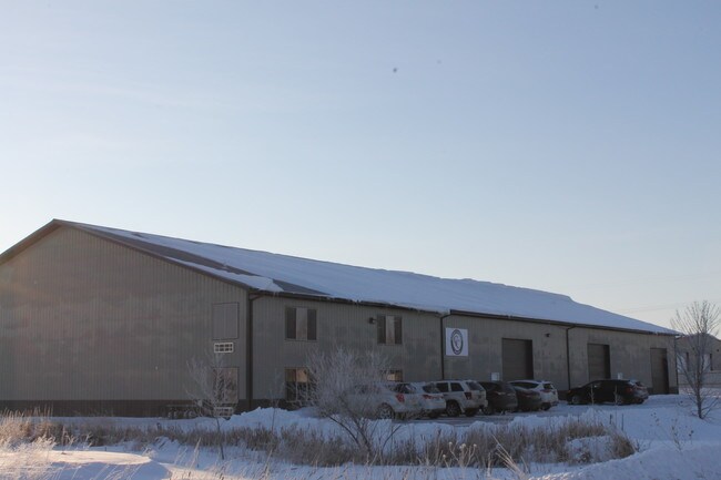
Property Detail
27294 Verhey Pl
Sioux Falls, SD-MN
VERHEY ADD - LOT 3 S12 GOV'T LOTS 1 & 2 - 31-100-50 -
100.50.31.K003
LINCOLN
Commercialnec
South Dakota
C COMMERCI
3-2
B and X Area of moderate flood hazard, usually the area between the limits of the 100-year and 500-year floods.
1.37 AC
2024
Sioux Falls
2024
Other Market Areas
010115
NEARBY LISTINGS FOR SALE OR LEASE
DEMOGRAPHICS near 27294 Verhey Pl
1 mile
3 mile
5 mile
2025 Total Population
408
10,352
46,198
2030 Population
457
11,752
51,572
Pop Growth 2025-2030
+ 12.01%
+ 13.52%
+ 11.63%
Average Age
40
35
36
2025 Total Households
142
3,616
17,260
HH Growth 2025-2030
+ 11.97%
+ 13.74%
+ 11.80%
Median Household Inc
$118,534
$106,521
$99,492
Avg Household Size
2.90
2.80
2.60
2025 Avg HH Vehicles
3.00
3.00
2.00
Median Home Value
$428,000
$366,731
$349,592
Median Year Built
1998
2008
2006
Nearby Places
Map Layers
Map Styles
 Street
 Aerial
Transit
 Traffic
 Biking
Places
Listings with unknown addresses are not visible on the map
- Restaurants
- Banks
- Shops
- Fitness
- Groceries
PUBLIC TRANSPORTATION
AIRPORT
Joe Foss Field
Drive
Walk
Distance
Joe Foss Field
22 min
14.6 mi
SALE & LEASE HISTORY
LISTING DATE
SALE/LEASE

Mar 21, 2019
For Sale
Nearby Properties
Address
Land Use
TOTAL SIZE
Lot Size
Zoning
Address
Land Use
TOTAL SIZE
Lot Size
Zoning
8.65 AC
MUNICIPALI
Address
Land Use
TOTAL SIZE
Lot Size
Zoning
11.80 AC
I-1 LIGHT
Address
Land Use
TOTAL SIZE
Lot Size
Zoning
8.28 AC
MUNICIPALI
Address
Land Use
TOTAL SIZE
Lot Size
Zoning
11.26 AC
MUNICIPALI
Address
Land Use
TOTAL SIZE
Lot Size
Zoning
3.56 AC
MUNICIPALI
Address
Land Use
TOTAL SIZE
Lot Size
Zoning
4.62 AC
MUNICIPALI
Address
Land Use
TOTAL SIZE
Lot Size
Zoning
5.14 AC
MUNICIPALI
Address
Land Use
TOTAL SIZE
Lot Size
Zoning
2.50 AC
MUNICIPALI
Address
Land Use
TOTAL SIZE
Lot Size
Zoning
2.48 AC
MUNICIPALI
Address
Land Use
TOTAL SIZE
Lot Size
Zoning
4.04 AC
C COMMERCI
Address
Land Use
TOTAL SIZE
Lot Size
Zoning
2.47 AC
MUNICIPALI
Address
Land Use
TOTAL SIZE
Lot Size
Zoning
1.56 AC
MUNICIPALI
Address
Land Use
TOTAL SIZE
Lot Size
Zoning
5.43 AC
MUNICIPALI
Address
Land Use
TOTAL SIZE
Lot Size
Zoning
2.11 AC
MUNICIPALI
Address
Land Use
TOTAL SIZE
Lot Size
Zoning
3.02 AC
MUNICIPALI
Address
Land Use
TOTAL SIZE
Lot Size
Zoning
9.50 AC
MUNICIPALI
Address
Land Use
TOTAL SIZE
Lot Size
Zoning
7.60 AC
MUNICIPALI
Address
Land Use
TOTAL SIZE
Lot Size
Zoning
3.60 AC
I-1 LIGHT
Address
Land Use
TOTAL SIZE
Lot Size
Zoning
4.72 AC
MUNICIPALI
Address
Land Use
TOTAL SIZE
Lot Size
Zoning
14.33 AC
MUNICIPALI
Address
Land Use
TOTAL SIZE
Lot Size
Zoning
3.18 AC
MUNICIPALI
Address
Land Use
TOTAL SIZE
Lot Size
Zoning
4.68 AC
C COMMERCI
Address
Land Use
TOTAL SIZE
Lot Size
Zoning
2.09 AC
MUNICIPALI
Address
Land Use
TOTAL SIZE
Lot Size
Zoning
2.08 AC
I-1 LIGHT
Address
Land Use
TOTAL SIZE
Lot Size
Zoning
3.04 AC
I-1 LIGHT
Address
Land Use
TOTAL SIZE
Lot Size
Zoning
2.33 AC
MUNICIPALI
Address
Land Use
TOTAL SIZE
Lot Size
Zoning
14.59 AC
MUNICIPALI
Address
Land Use
TOTAL SIZE
Lot Size
Zoning
2.39 AC
MUNICIPALI
Address
Land Use
TOTAL SIZE
Lot Size
Zoning
4.08 AC
MUNICIPALI
Address
Land Use
TOTAL SIZE
Lot Size
Zoning
1.80 AC
MUNICIPALI
The World's #1 Commercial Real Estate Marketplace
Connect with us
© 2026 CoStar Group
The information above has been obtained from sources believed reliable. While we do not doubt its accuracy we have not verified it and make no guarantee, warranty or representation about it. It is your responsibility to independently confirm its accuracy and completeness. Any projections, opinions, assumptions, or estimates used are for example only and do not represent the current or future performance of the property. The value of this transaction to you depends on tax and other factors which should be evaluated by your tax, financial, and legal advisors. You and your advisors should conduct a careful, independent investigation of the property to determine to your satisfaction the suitability of the property for your needs.