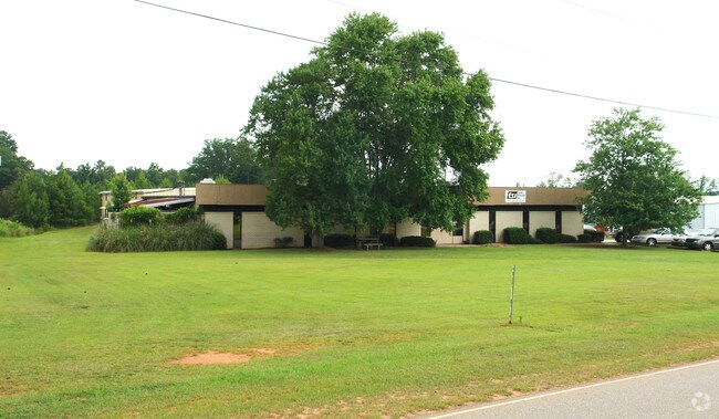
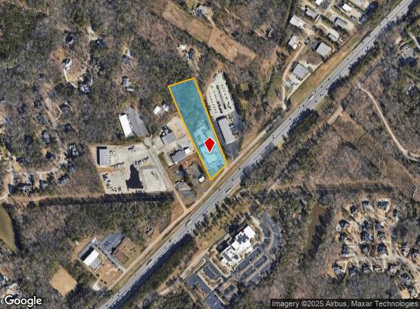
Property Record
273 Riverchase Way, Lexington, SC 29072


NEARBY LISTINGS FOR SALE OR LEASE
Property Detail
273 Riverchase Way
003698-03-005
TRACTS A,B & UNNUMB PARCEL
Autorepair
Lexington
X
South Carolina
45063C0144J
4.66 AC
2025
Lexington
2024
Columbia
020506
Columbia, SC
17,572 SF
DEMOGRAPHICS near 273 Riverchase Way
1 Mile
3 Mile
5 Mile
2024 Total Population
1,514
45,493
125,167
2029 Population
1,662
48,898
133,181
Pop Growth 2024-2029
+ 9.78%
+ 7.48%
+ 6.40%
Average Age
48
39
39
2024 Total Households
627
19,668
53,265
HH Growth 2024-2029
+ 9.89%
+ 7.50%
+ 6.57%
Median Household Inc
$72,906
$58,253
$56,492
Avg Household Size
2.30
2.20
2.20
2024 Avg HH Vehicles
2.00
2.00
2.00
Median Home Value
$267,342
$181,165
$171,970
Median Year Built
1978
1981
1981
Nearby Places
Map Layers
Map Styles
 Street
 Aerial
- Restaurants
- Banks
- Shops
- Fitness
- Groceries
PUBLIC TRANSPORTATION
COMMUTER RAIL
Columbia Amtrak Station (Silver Star - Amtrak)
DRIVE
WALK
Distance
Columbia Amtrak Station (Silver Star - Amtrak)
15 min
8.2 mi
AIRPORT
Columbia Metro
DRIVE
WALK
Distance
Columbia Metro
24 min
11.5 mi
Freight Ports
North Charleston Terminal
DRIVE
WALK
Distance
North Charleston Terminal
124 min
107.8 mi
Nearby Properties
Address
Land Use
TOTAL SIZE
Lot Size
Zoning
Address
Land Use
TOTAL SIZE
Lot Size
Zoning
128,160 SF
9.31 AC
RM-HD
Address
Land Use
TOTAL SIZE
Lot Size
Zoning
358,561 SF
42.10 AC
EC
Address
Land Use
TOTAL SIZE
Lot Size
Zoning
128,877 SF
24.71 AC
RM-HD
Address
Land Use
TOTAL SIZE
Lot Size
Zoning
9,620 SF
18.91 AC
GC
Address
Land Use
TOTAL SIZE
Lot Size
Zoning
183,392 SF
14.77 AC
RM-HD
Address
Land Use
TOTAL SIZE
Lot Size
Zoning
129,108 SF
11.90 AC
RM-HD
Address
Land Use
TOTAL SIZE
Lot Size
Zoning
169,278 SF
12.21 AC
RM-HD
Address
Land Use
TOTAL SIZE
Lot Size
Zoning
100 SF
465.41 AC
INS-GEN
Address
Land Use
TOTAL SIZE
Lot Size
Zoning
192,966 SF
13.23 AC
RM-HD
Address
Land Use
TOTAL SIZE
Lot Size
Zoning
204,968 SF
17.39 AC
RM-HD
Address
Land Use
TOTAL SIZE
Lot Size
Zoning
89,376 SF
6.85 AC
CAC
Address
Land Use
TOTAL SIZE
Lot Size
Zoning
307,287 SF
22.18 AC
RM-HD
Address
Land Use
TOTAL SIZE
Lot Size
Zoning
44,296 SF
14.01 AC
GC
Address
Land Use
TOTAL SIZE
Lot Size
Zoning
147,408 SF
17.49 AC
M-1
Address
Land Use
TOTAL SIZE
Lot Size
Zoning
82,874 SF
6.99 AC
GC
Address
Land Use
TOTAL SIZE
Lot Size
Zoning
151,470 SF
8.44 AC
RM-2
Address
Land Use
TOTAL SIZE
Lot Size
Zoning
81,900 SF
4.95 AC
EC
Address
Land Use
TOTAL SIZE
Lot Size
Zoning
78,288 SF
5.14 AC
GC
Address
Land Use
TOTAL SIZE
Lot Size
Zoning
88,466 SF
9.41 AC
RM-HD
Address
Land Use
TOTAL SIZE
Lot Size
Zoning
107,578 SF
10.32 AC
RM-HD
Address
Land Use
TOTAL SIZE
Lot Size
Zoning
208,016 SF
14.28 AC
GC
Address
Land Use
TOTAL SIZE
Lot Size
Zoning
93,792 SF
9.38 AC
RM-HD
Address
Land Use
TOTAL SIZE
Lot Size
Zoning
282,660 SF
41.39 AC
RAC
Address
Land Use
TOTAL SIZE
Lot Size
Zoning
70,000 SF
11.32 AC
LI
Address
Land Use
TOTAL SIZE
Lot Size
Zoning
42,072 SF
2.01 AC
GC
Address
Land Use
TOTAL SIZE
Lot Size
Zoning
117,670 SF
9.95 AC
GC
Address
Land Use
TOTAL SIZE
Lot Size
Zoning
93,384 SF
7.24 AC
EC
Address
Land Use
TOTAL SIZE
Lot Size
Zoning
3.29 AC
OI
Address
Land Use
TOTAL SIZE
Lot Size
Zoning
40,800 SF
7 AC
CAC
Address
Land Use
TOTAL SIZE
Lot Size
Zoning
77,016 SF
5.05 AC
GC
The World's #1 Commercial Real Estate Marketplace
Connect with us
© 2025 CoStar Group
The information above has been obtained from sources believed reliable. While we do not doubt its accuracy we have not verified it and make no guarantee, warranty or representation about it. It is your responsibility to independently confirm its accuracy and completeness. Any projections, opinions, assumptions, or estimates used are for example only and do not represent the current or future performance of the property. The value of this transaction to you depends on tax and other factors which should be evaluated by your tax, financial, and legal advisors. You and your advisors should conduct a careful, independent investigation of the property to determine to your satisfaction the suitability of the property for your needs.