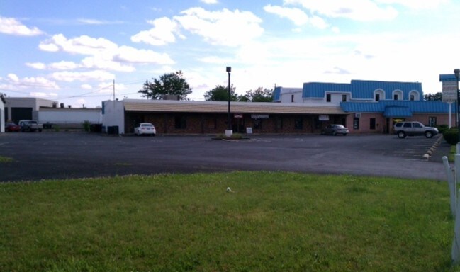
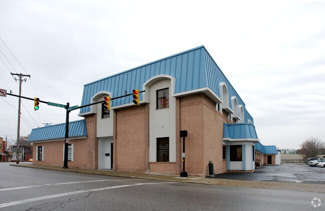
Property Record
273 Wooster Rd N, Barberton, OH 44203

Property Detail
273 Wooster Rd N
Akron, OH
COR RDS N PORTAGE LOT 1 ALL LESS 18X83.4FT .330A
01-07461
SUMMIT
Officebuilding
Ohio
B and X Area of moderate flood hazard, usually the area between the limits of the 100-year and 500-year floods.
1
2025
0.33 AC
2026
Akron
510100
Cleveland
15,613 SF
NEARBY LISTINGS FOR SALE OR LEASE
DEMOGRAPHICS near 273 Wooster Rd N
1 mile
3 mile
5 mile
2025 Total Population
8,487
44,704
99,669
2030 Population
8,458
44,703
99,881
Pop Growth 2025-2030
(0.34%)
0.00%
+ 0.21%
Average Age
41
42
42
2025 Total Households
3,636
19,332
43,108
HH Growth 2025-2030
(0.36%)
(0.04%)
+ 0.19%
Median Household Inc
$45,879
$56,165
$54,199
Avg Household Size
2.20
2.30
2.20
2025 Avg HH Vehicles
1.00
2.00
2.00
Median Home Value
$130,362
$149,641
$148,367
Median Year Built
1948
1955
1956
Nearby Places
Map Layers
Map Styles
 Street
 Aerial
Layers
 Traffic
 Biking
Places
Listings with unknown addresses are not visible on the map
- Restaurants
- Banks
- Shops
- Fitness
- Groceries
PUBLIC TRANSPORTATION
COMMUTER RAIL
Drive
Walk
Distance
15 min
7.5 mi
AIRPORT
Akron-Canton Regional
Drive
Walk
Distance
Akron-Canton Regional
23 min
15.7 mi
Cleveland-Hopkins International
Drive
Walk
Distance
Cleveland-Hopkins International
60 min
40.4 mi
SALE & LEASE HISTORY
LISTING DATE
SALE/LEASE

Sep 25, 2016
For Lease
Nearby Properties
Address
Land Use
TOTAL SIZE
Lot Size
Zoning
Address
Land Use
TOTAL SIZE
Lot Size
Zoning
1,397,532 SF
92.95 AC
Address
Land Use
TOTAL SIZE
Lot Size
Zoning
148,344 SF
40.32 AC
Address
Land Use
TOTAL SIZE
Lot Size
Zoning
252,222 SF
12.65 AC
Address
Land Use
TOTAL SIZE
Lot Size
Zoning
Address
Land Use
TOTAL SIZE
Lot Size
Zoning
Address
Land Use
TOTAL SIZE
Lot Size
Zoning
132,611 SF
3.56 AC
Address
Land Use
TOTAL SIZE
Lot Size
Zoning
91,678 SF
5.24 AC
Address
Land Use
TOTAL SIZE
Lot Size
Zoning
166,625 SF
11.37 AC
Address
Land Use
TOTAL SIZE
Lot Size
Zoning
Address
Land Use
TOTAL SIZE
Lot Size
Zoning
34.80 AC
Address
Land Use
TOTAL SIZE
Lot Size
Zoning
24,812 SF
29.15 AC
Address
Land Use
TOTAL SIZE
Lot Size
Zoning
Address
Land Use
TOTAL SIZE
Lot Size
Zoning
295,142 SF
24.69 AC
Address
Land Use
TOTAL SIZE
Lot Size
Zoning
87,486 SF
7.25 AC
Address
Land Use
TOTAL SIZE
Lot Size
Zoning
142,266 SF
8.15 AC
Address
Land Use
TOTAL SIZE
Lot Size
Zoning
204,276 SF
28.95 AC
Address
Land Use
TOTAL SIZE
Lot Size
Zoning
29,161 SF
15.94 AC
Address
Land Use
TOTAL SIZE
Lot Size
Zoning
Address
Land Use
TOTAL SIZE
Lot Size
Zoning
99,931 SF
16.82 AC
Address
Land Use
TOTAL SIZE
Lot Size
Zoning
253,690 SF
12.18 AC
Address
Land Use
TOTAL SIZE
Lot Size
Zoning
130,893 SF
11.70 AC
Address
Land Use
TOTAL SIZE
Lot Size
Zoning
59,492 SF
5.51 AC
Address
Land Use
TOTAL SIZE
Lot Size
Zoning
112,894 SF
12.26 AC
Address
Land Use
TOTAL SIZE
Lot Size
Zoning
77,444 SF
13.02 AC
Address
Land Use
TOTAL SIZE
Lot Size
Zoning
994,273 SF
58.70 AC
Address
Land Use
TOTAL SIZE
Lot Size
Zoning
125,245 SF
6.11 AC
Address
Land Use
TOTAL SIZE
Lot Size
Zoning
20,000 SF
23.71 AC
Address
Land Use
TOTAL SIZE
Lot Size
Zoning
832 SF
16.75 AC
Address
Land Use
TOTAL SIZE
Lot Size
Zoning
5,520 SF
68.52 AC
Address
Land Use
TOTAL SIZE
Lot Size
Zoning
70,783 SF
15.97 AC
The World's #1 Commercial Real Estate Marketplace
Connect with us
© 2026 CoStar Group
The information above has been obtained from sources believed reliable. While we do not doubt its accuracy we have not verified it and make no guarantee, warranty or representation about it. It is your responsibility to independently confirm its accuracy and completeness. Any projections, opinions, assumptions, or estimates used are for example only and do not represent the current or future performance of the property. The value of this transaction to you depends on tax and other factors which should be evaluated by your tax, financial, and legal advisors. You and your advisors should conduct a careful, independent investigation of the property to determine to your satisfaction the suitability of the property for your needs.