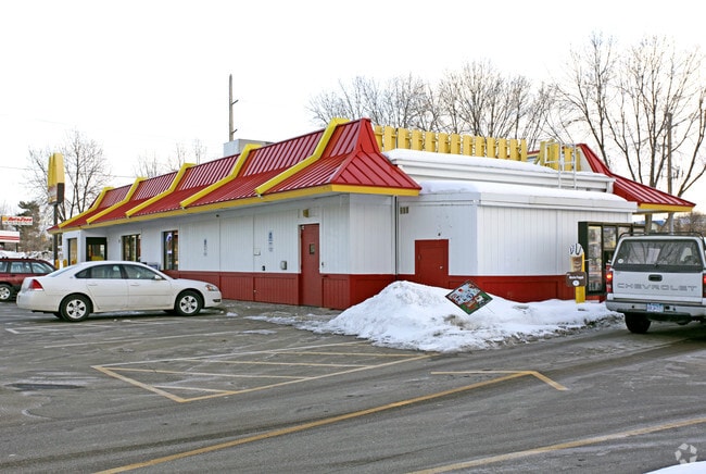
Property Record
2730 Minnehaha Ave E, Saint Paul, MN 55119
NEARBY LISTINGS FOR SALE OR LEASE
Property Detail
2730 Minnehaha Ave E
Minneapolis-St. Paul-Bloomington, MN-WI
Farrells Add.
36-29-22-11-0055
FARRELLS ADD. SUBJ TO HWY; THE N 198 FT OF LOT 1 & LOT 2 BLK 1
Restaurantdrivein
Ramsey
X
Minnesota
27123C0130G
1,2
2024
0.95 AC
2025
Woodbury
042501
Minneapolis/St Paul
3,493 SF
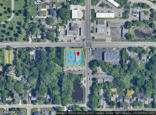
DEMOGRAPHICS near 2730 Minnehaha Ave E
1 Mile
3 Mile
5 Mile
2024 Total Population
8,681
95,307
216,098
2029 Population
9,100
95,734
217,733
Pop Growth 2024-2029
+ 4.83%
+ 0.45%
+ 0.76%
Average Age
39
37
37
2024 Total Households
3,492
34,854
77,706
HH Growth 2024-2029
+ 4.93%
+ 0.73%
+ 1.07%
Median Household Inc
$67,002
$70,394
$74,237
Avg Household Size
2.40
2.60
2.60
2024 Avg HH Vehicles
2.00
2.00
2.00
Median Home Value
$253,567
$249,072
$273,449
Median Year Built
1971
1974
1975
Nearby Places
Map Layers
Map Styles
 Street
 Aerial
- Restaurants
- Banks
- Shops
- Fitness
- Groceries
PUBLIC TRANSPORTATION
COMMUTER RAIL
St. Paul-Minneapolis (Empire Builder - Amtrak)
DRIVE
WALK
Distance
St. Paul-Minneapolis (Empire Builder - Amtrak)
10 min
5.6 mi
AIRPORT
Minneapolis-St Paul International/Wold-Chamberlain
DRIVE
WALK
Distance
Minneapolis-St Paul International/Wold-Chamberlain
25 min
15.8 mi
Freight Ports
Port Milwaukee
DRIVE
WALK
Distance
Port Milwaukee
357 min
324.8 mi
Nearby Properties
Address
Land Use
TOTAL SIZE
Lot Size
Zoning
Address
Land Use
TOTAL SIZE
Lot Size
Zoning
267,948 SF
372.92 AC
Address
Land Use
TOTAL SIZE
Lot Size
Zoning
114,777 SF
22.45 AC
Address
Land Use
TOTAL SIZE
Lot Size
Zoning
270,348 SF
35.96 AC
Address
Land Use
TOTAL SIZE
Lot Size
Zoning
127,888 SF
141.04 AC
Address
Land Use
TOTAL SIZE
Lot Size
Zoning
460,439 SF
25.26 AC
Address
Land Use
TOTAL SIZE
Lot Size
Zoning
29.55 AC
Address
Land Use
TOTAL SIZE
Lot Size
Zoning
296,529 SF
31.80 AC
Address
Land Use
TOTAL SIZE
Lot Size
Zoning
228,036 SF
31.11 AC
Address
Land Use
TOTAL SIZE
Lot Size
Zoning
81,006 SF
12.05 AC
Address
Land Use
TOTAL SIZE
Lot Size
Zoning
147,199 SF
32.47 AC
Address
Land Use
TOTAL SIZE
Lot Size
Zoning
53,851 SF
22.74 AC
Address
Land Use
TOTAL SIZE
Lot Size
Zoning
311,332 SF
36.34 AC
Address
Land Use
TOTAL SIZE
Lot Size
Zoning
181.88 AC
Address
Land Use
TOTAL SIZE
Lot Size
Zoning
246,000 SF
31.03 AC
Address
Land Use
TOTAL SIZE
Lot Size
Zoning
85,400 SF
6.43 AC
Address
Land Use
TOTAL SIZE
Lot Size
Zoning
9.90 AC
Address
Land Use
TOTAL SIZE
Lot Size
Zoning
41,868 SF
6.69 AC
Address
Land Use
TOTAL SIZE
Lot Size
Zoning
262,872 SF
14.22 AC
Address
Land Use
TOTAL SIZE
Lot Size
Zoning
96,587 SF
17.42 AC
Address
Land Use
TOTAL SIZE
Lot Size
Zoning
13.43 AC
Address
Land Use
TOTAL SIZE
Lot Size
Zoning
41,201 SF
9.55 AC
Address
Land Use
TOTAL SIZE
Lot Size
Zoning
256,440 SF
27.44 AC
Address
Land Use
TOTAL SIZE
Lot Size
Zoning
371,200 SF
8.99 AC
Address
Land Use
TOTAL SIZE
Lot Size
Zoning
Address
Land Use
TOTAL SIZE
Lot Size
Zoning
222,374 SF
43.99 AC
Address
Land Use
TOTAL SIZE
Lot Size
Zoning
Address
Land Use
TOTAL SIZE
Lot Size
Zoning
75,825 SF
19.49 AC
Address
Land Use
TOTAL SIZE
Lot Size
Zoning
111,528 SF
20.30 AC
Address
Land Use
TOTAL SIZE
Lot Size
Zoning
78,278 SF
4.08 AC
The World's #1 Commercial Real Estate Marketplace
Connect with us
© 2025 CoStar Group
The information above has been obtained from sources believed reliable. While we do not doubt its accuracy we have not verified it and make no guarantee, warranty or representation about it. It is your responsibility to independently confirm its accuracy and completeness. Any projections, opinions, assumptions, or estimates used are for example only and do not represent the current or future performance of the property. The value of this transaction to you depends on tax and other factors which should be evaluated by your tax, financial, and legal advisors. You and your advisors should conduct a careful, independent investigation of the property to determine to your satisfaction the suitability of the property for your needs.