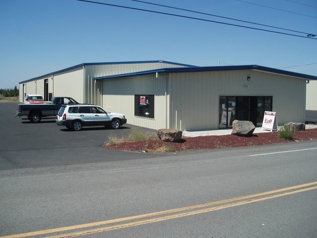
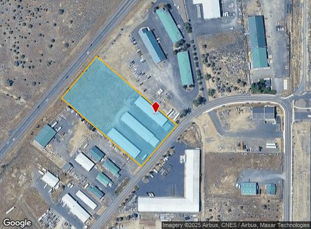
Property Record
2731 Sw High Desert Dr, Prineville, OR 97754

NEARBY LISTINGS FOR SALE OR LEASE
Property Detail
2731 Sw High Desert Dr
Prineville, OR
Baldwin Road Industrial Park
014545
SECTION 12 TOWNSHIP 15S RANGE 15E QUARTER NW PCRL 400 SUBDIVISION: BALDWIN ROAD INDUSTRIAL PARK LOT: 20 MAPTAXLOT: 151512B000400
Industrialgeneral
Crook
X
Oregon
41013C0400C
20
2025
4 AC
2025
Bend/Redmond
950301
Other Market Areas
10,000 SF
DEMOGRAPHICS near 2731 Sw High Desert Dr
1 Mile
3 Mile
5 Mile
2024 Total Population
197
10,495
15,994
2029 Population
232
12,241
18,710
Pop Growth 2024-2029
+ 17.77%
+ 16.64%
+ 16.98%
Average Age
41
41
42
2024 Total Households
69
4,205
6,387
HH Growth 2024-2029
+ 17.39%
+ 16.86%
+ 17.21%
Median Household Inc
$38,448
$49,496
$60,635
Avg Household Size
2.50
2.40
2.40
2024 Avg HH Vehicles
2.00
2.00
2.00
Median Home Value
$136,111
$289,806
$333,239
Median Year Built
1960
1976
1985
Nearby Places
Map Layers
Map Styles
 Street
 Aerial
- Restaurants
- Banks
- Shops
- Fitness
- Groceries
PUBLIC TRANSPORTATION
AIRPORT
Roberts Field
DRIVE
WALK
Distance
Roberts Field
23 min
16.7 mi
Freight Ports
Port of Portland
DRIVE
WALK
Distance
Port of Portland
226 min
152.7 mi
SALE & LEASE HISTORY
LISTING DATE
SALE/LEASE

Nov 26, 2024
For Lease
Aug 22, 2025
For Lease
Nearby Properties
Address
Land Use
TOTAL SIZE
Lot Size
Zoning
Address
Land Use
TOTAL SIZE
Lot Size
Zoning
68,850 SF
1.38 AC
C1
Address
Land Use
TOTAL SIZE
Lot Size
Zoning
1 SF
50 AC
IP
Address
Land Use
TOTAL SIZE
Lot Size
Zoning
6.16 AC
R2
Address
Land Use
TOTAL SIZE
Lot Size
Zoning
5,240 SF
449.07 AC
HM
Address
Land Use
TOTAL SIZE
Lot Size
Zoning
4.70 AC
C2
Address
Land Use
TOTAL SIZE
Lot Size
Zoning
1 SF
8.02 AC
C2
Address
Land Use
TOTAL SIZE
Lot Size
Zoning
5,240 SF
795.50 AC
AC
Address
Land Use
TOTAL SIZE
Lot Size
Zoning
202.87 AC
PR
Address
Land Use
TOTAL SIZE
Lot Size
Zoning
33,854 SF
1.52 AC
R4
Address
Land Use
TOTAL SIZE
Lot Size
Zoning
7,089 SF
46.68 AC
C5
Address
Land Use
TOTAL SIZE
Lot Size
Zoning
1 SF
1.25 AC
R2
Address
Land Use
TOTAL SIZE
Lot Size
Zoning
83,366 SF
2.10 AC
M1
Address
Land Use
TOTAL SIZE
Lot Size
Zoning
38,165 SF
1.38 AC
C2
Address
Land Use
TOTAL SIZE
Lot Size
Zoning
80.35 AC
M1
Address
Land Use
TOTAL SIZE
Lot Size
Zoning
1 SF
13.67 AC
M2
Address
Land Use
TOTAL SIZE
Lot Size
Zoning
5.15 AC
M1
Address
Land Use
TOTAL SIZE
Lot Size
Zoning
35,030 SF
2.90 AC
C2
Address
Land Use
TOTAL SIZE
Lot Size
Zoning
Address
Land Use
TOTAL SIZE
Lot Size
Zoning
1 SF
37.07 AC
R2
Address
Land Use
TOTAL SIZE
Lot Size
Zoning
1 SF
15.48 AC
IP
Address
Land Use
TOTAL SIZE
Lot Size
Zoning
31,344 SF
2.39 AC
C2
Address
Land Use
TOTAL SIZE
Lot Size
Zoning
24,148 SF
1.55 AC
C2
Address
Land Use
TOTAL SIZE
Lot Size
Zoning
12,887 SF
0.70 AC
C1
Address
Land Use
TOTAL SIZE
Lot Size
Zoning
25,576 SF
1.50 AC
C2
Address
Land Use
TOTAL SIZE
Lot Size
Zoning
1 SF
22.48 AC
M2
Address
Land Use
TOTAL SIZE
Lot Size
Zoning
59,500 SF
5.08 AC
IP
Address
Land Use
TOTAL SIZE
Lot Size
Zoning
1.22 AC
R2
Address
Land Use
TOTAL SIZE
Lot Size
Zoning
12,918 SF
3.05 AC
C2
Address
Land Use
TOTAL SIZE
Lot Size
Zoning
10,800 SF
5.51 AC
IP
Address
Land Use
TOTAL SIZE
Lot Size
Zoning
1 SF
1.25 AC
C2
The World's #1 Commercial Real Estate Marketplace
Connect with us
© 2026 CoStar Group
The information above has been obtained from sources believed reliable. While we do not doubt its accuracy we have not verified it and make no guarantee, warranty or representation about it. It is your responsibility to independently confirm its accuracy and completeness. Any projections, opinions, assumptions, or estimates used are for example only and do not represent the current or future performance of the property. The value of this transaction to you depends on tax and other factors which should be evaluated by your tax, financial, and legal advisors. You and your advisors should conduct a careful, independent investigation of the property to determine to your satisfaction the suitability of the property for your needs.