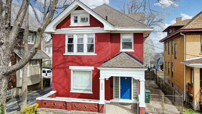
Property Record
2732 Madison Rd, Cincinnati, OH 45209

Property Detail
2732 Madison Rd
Cincinnati, OH-KY-IN
2732 MADISON RD 43.02 X 94.57 IRR LOT 42 LEWIS R SMITH SUB
040-0004-0127
Hamilton
Multifamilydwelling
Ohio
B and X Area of moderate flood hazard, usually the area between the limits of the 100-year and 500-year floods.
42
2025
0.10 AC
2025
Fairfax/Mt. Lookout
005200
Cincinnati/Dayton
2,991 SF
NEARBY LISTINGS FOR SALE OR LEASE
DEMOGRAPHICS near 2732 Madison Rd
1 mile
3 mile
5 mile
2025 Total Population
18,620
116,962
286,518
2030 Population
18,614
118,521
291,247
Pop Growth 2025-2030
(0.03%)
+ 1.33%
+ 1.65%
Average Age
38
38
38
2025 Total Households
9,589
54,888
129,274
HH Growth 2025-2030
(0.07%)
+ 1.32%
+ 1.76%
Median Household Inc
$98,977
$69,026
$66,505
Avg Household Size
1.90
2.00
2.00
2025 Avg HH Vehicles
2.00
1.00
2.00
Median Home Value
$428,895
$320,195
$298,027
Median Year Built
1946
1948
1949
Nearby Places
Map Layers
Map Styles
 Street
 Aerial
Layers
 Traffic
 Biking
Places
Listings with unknown addresses are not visible on the map
- Restaurants
- Banks
- Shops
- Fitness
- Groceries
PUBLIC TRANSPORTATION
COMMUTER RAIL
Drive
Walk
Distance
14 min
8.2 mi
AIRPORT
Cincinnati/Northern Kentucky International
Drive
Walk
Distance
Cincinnati/Northern Kentucky International
35 min
20.3 mi
SALE & LEASE HISTORY
LISTING DATE
SALE/LEASE

Apr 07, 2022
For Sale
Nearby Properties
Address
Land Use
TOTAL SIZE
Lot Size
Zoning
Address
Land Use
TOTAL SIZE
Lot Size
Zoning
62.10 AC
Address
Land Use
TOTAL SIZE
Lot Size
Zoning
13.80 AC
Address
Land Use
TOTAL SIZE
Lot Size
Zoning
Address
Land Use
TOTAL SIZE
Lot Size
Zoning
27.30 AC
M2
Address
Land Use
TOTAL SIZE
Lot Size
Zoning
11.68 AC
Address
Land Use
TOTAL SIZE
Lot Size
Zoning
26,453 SF
19.91 AC
M2
Address
Land Use
TOTAL SIZE
Lot Size
Zoning
148,748 SF
24.90 AC
CGA
Address
Land Use
TOTAL SIZE
Lot Size
Zoning
3.17 AC
R2PUD
Address
Land Use
TOTAL SIZE
Lot Size
Zoning
9.16 AC
Address
Land Use
TOTAL SIZE
Lot Size
Zoning
Address
Land Use
TOTAL SIZE
Lot Size
Zoning
8.05 AC
Address
Land Use
TOTAL SIZE
Lot Size
Zoning
Address
Land Use
TOTAL SIZE
Lot Size
Zoning
5.07 AC
Address
Land Use
TOTAL SIZE
Lot Size
Zoning
Address
Land Use
TOTAL SIZE
Lot Size
Zoning
6.93 AC
MG
Address
Land Use
TOTAL SIZE
Lot Size
Zoning
Address
Land Use
TOTAL SIZE
Lot Size
Zoning
2,916 SF
27.68 AC
Address
Land Use
TOTAL SIZE
Lot Size
Zoning
Address
Land Use
TOTAL SIZE
Lot Size
Zoning
3.34 AC
Address
Land Use
TOTAL SIZE
Lot Size
Zoning
83,122 SF
1.99 AC
Address
Land Use
TOTAL SIZE
Lot Size
Zoning
6.91 AC
Address
Land Use
TOTAL SIZE
Lot Size
Zoning
3,864 SF
0.15 AC
PD
Address
Land Use
TOTAL SIZE
Lot Size
Zoning
4.57 AC
Address
Land Use
TOTAL SIZE
Lot Size
Zoning
4,706 SF
18.29 AC
RM20
Address
Land Use
TOTAL SIZE
Lot Size
Zoning
7.06 AC
Address
Land Use
TOTAL SIZE
Lot Size
Zoning
6.80 AC
Address
Land Use
TOTAL SIZE
Lot Size
Zoning
1,152 SF
24.78 AC
B
Address
Land Use
TOTAL SIZE
Lot Size
Zoning
2.17 AC
O
Address
Land Use
TOTAL SIZE
Lot Size
Zoning
18.51 AC
RM20
Address
Land Use
TOTAL SIZE
Lot Size
Zoning
1,187 SF
31.75 AC
ML
The World's #1 Commercial Real Estate Marketplace
Connect with us
© 2026 CoStar Group
The information above has been obtained from sources believed reliable. While we do not doubt its accuracy we have not verified it and make no guarantee, warranty or representation about it. It is your responsibility to independently confirm its accuracy and completeness. Any projections, opinions, assumptions, or estimates used are for example only and do not represent the current or future performance of the property. The value of this transaction to you depends on tax and other factors which should be evaluated by your tax, financial, and legal advisors. You and your advisors should conduct a careful, independent investigation of the property to determine to your satisfaction the suitability of the property for your needs.