Property Record
27332 Frontage Rd, La Junta, CO 81050
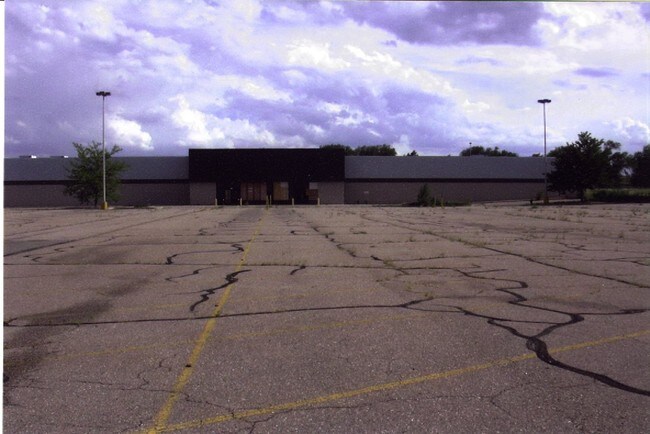

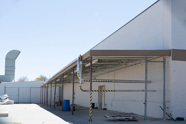
Property Detail
27332 Frontage Rd
Other Market Areas
PARCEL #2 PT OF LOT 4 & PT OF SE1/4NW1/4 4-24-55 MORE; PART DES AS FOL: BEG AT THESW'LY COR OF LOT 1 RAYL'S; SUB TH S 73 DEG
4643-040-00009
Otero
Commercialnec
Colorado
2025
4-10
2025
8.28 AC
968300
Colorado East Area
46,087 SF
NEARBY LISTINGS FOR SALE OR LEASE
DEMOGRAPHICS near 27332 Frontage Rd
1 mile
3 mile
5 mile
2025 Total Population
398
8,286
9,398
2030 Population
396
8,076
9,151
Pop Growth 2025-2030
(0.50%)
(2.53%)
(2.63%)
Average Age
43
40
40
2025 Total Households
163
3,402
3,846
HH Growth 2025-2030
(0.61%)
(2.62%)
(2.70%)
Median Household Inc
$148,957
$64,372
$65,552
Avg Household Size
2.40
2.30
2.40
2025 Avg HH Vehicles
2.00
2.00
2.00
Median Home Value
$176,922
$199,579
$199,399
Median Year Built
1961
1964
1965
Nearby Places
Map Layers
Map Styles
 Street
 Aerial
Transit
 Traffic
 Biking
Places
Listings with unknown addresses are not visible on the map
- Restaurants
- Banks
- Shops
- Fitness
- Groceries
PUBLIC TRANSPORTATION
COMMUTER RAIL
La Junta Amtrak Station (Southwest Chief - Amtrak)
Drive
Walk
Distance
La Junta Amtrak Station (Southwest Chief - Amtrak)
5 min
2.1 mi
Freight Ports
Tulsa Port Of Catoosa
Drive
Walk
Distance
Tulsa Port Of Catoosa
681 min
555.0 mi
SALE & LEASE HISTORY
LISTING DATE
SALE/LEASE

Apr 01, 2022
For Lease
Nearby Properties
Address
Land Use
TOTAL SIZE
Lot Size
Zoning
Address
Land Use
TOTAL SIZE
Lot Size
Zoning
31,827 SF
2.13 AC
Address
Land Use
TOTAL SIZE
Lot Size
Zoning
5,225 SF
2.07 AC
Address
Land Use
TOTAL SIZE
Lot Size
Zoning
43,000 SF
28.30 AC
Address
Land Use
TOTAL SIZE
Lot Size
Zoning
15,433 SF
1.76 AC
Address
Land Use
TOTAL SIZE
Lot Size
Zoning
24,228 SF
3.10 AC
Address
Land Use
TOTAL SIZE
Lot Size
Zoning
38,891 SF
7.60 AC
Address
Land Use
TOTAL SIZE
Lot Size
Zoning
64,848 SF
4.58 AC
Address
Land Use
TOTAL SIZE
Lot Size
Zoning
32,742 SF
3.37 AC
Address
Land Use
TOTAL SIZE
Lot Size
Zoning
32,615 SF
1.75 AC
Address
Land Use
TOTAL SIZE
Lot Size
Zoning
14,034 SF
2.02 AC
Address
Land Use
TOTAL SIZE
Lot Size
Zoning
37,830 SF
0.79 AC
Address
Land Use
TOTAL SIZE
Lot Size
Zoning
143,342 SF
18.40 AC
Address
Land Use
TOTAL SIZE
Lot Size
Zoning
12,000 SF
1.14 AC
Address
Land Use
TOTAL SIZE
Lot Size
Zoning
2,160 SF
2.78 AC
Address
Land Use
TOTAL SIZE
Lot Size
Zoning
24,805 SF
3.85 AC
Address
Land Use
TOTAL SIZE
Lot Size
Zoning
92,124 SF
Address
Land Use
TOTAL SIZE
Lot Size
Zoning
30,150 SF
Address
Land Use
TOTAL SIZE
Lot Size
Zoning
18,547 SF
0.96 AC
Address
Land Use
TOTAL SIZE
Lot Size
Zoning
10,000 SF
3.21 AC
Address
Land Use
TOTAL SIZE
Lot Size
Zoning
11,460 SF
0.68 AC
Address
Land Use
TOTAL SIZE
Lot Size
Zoning
6,316 SF
0.44 AC
Address
Land Use
TOTAL SIZE
Lot Size
Zoning
91,625 SF
Address
Land Use
TOTAL SIZE
Lot Size
Zoning
30,080 SF
4.06 AC
Address
Land Use
TOTAL SIZE
Lot Size
Zoning
5,390 SF
0.48 AC
Address
Land Use
TOTAL SIZE
Lot Size
Zoning
34,121 SF
1.76 AC
Address
Land Use
TOTAL SIZE
Lot Size
Zoning
20,192 SF
0.54 AC
Address
Land Use
TOTAL SIZE
Lot Size
Zoning
977 SF
2.07 AC
Address
Land Use
TOTAL SIZE
Lot Size
Zoning
0.16 AC
Address
Land Use
TOTAL SIZE
Lot Size
Zoning
16,200 SF
20.68 AC
The World's #1 Commercial Real Estate Marketplace
Connect with us
© 2026 CoStar Group
The information above has been obtained from sources believed reliable. While we do not doubt its accuracy we have not verified it and make no guarantee, warranty or representation about it. It is your responsibility to independently confirm its accuracy and completeness. Any projections, opinions, assumptions, or estimates used are for example only and do not represent the current or future performance of the property. The value of this transaction to you depends on tax and other factors which should be evaluated by your tax, financial, and legal advisors. You and your advisors should conduct a careful, independent investigation of the property to determine to your satisfaction the suitability of the property for your needs.