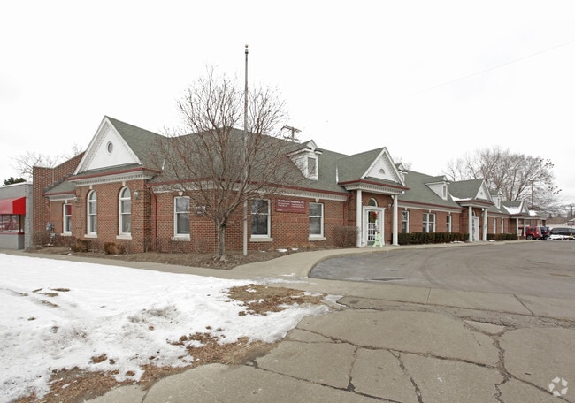
Property Record
27332 Woodward Ave, Royal Oak, MI 48067


Current Lease Availabilities
NEARBY LISTINGS FOR SALE OR LEASE
Property Detail
27332 Woodward Ave
Detroit-Warren-Dearborn, MI
16 Wilks Sub
25-16-356-040
T1N, R11E, SEC 16 WILKS SUB OUTLOT A, ALSO S 22 FT OF LOTS 55 & 56 & S 16.56 FT OF LOT 54 OF 'MAPLE GROVE SUB' & ALL OF VAC
Medicalbuilding
Oakland
X
Michigan
26163C0100E
54
2024
0.54 AC
2025
Royal Oak
184100
Detroit
5,797 SF
DEMOGRAPHICS near 27332 Woodward Ave
1 Mile
3 Mile
5 Mile
2024 Total Population
17,181
143,709
348,438
2029 Population
17,055
142,345
344,250
Pop Growth 2024-2029
(0.73%)
(0.95%)
(1.20%)
Average Age
41
40
41
2024 Total Households
8,147
67,140
155,674
HH Growth 2024-2029
(0.55%)
(0.90%)
(1.16%)
Median Household Inc
$107,596
$83,148
$71,660
Avg Household Size
2.10
2.10
2.20
2024 Avg HH Vehicles
2.00
2.00
2.00
Median Home Value
$342,646
$250,375
$217,649
Median Year Built
1950
1955
1957
Nearby Places
Map Layers
Map Styles
 Street
 Aerial
- Restaurants
- Banks
- Shops
- Fitness
- Groceries
PUBLIC TRANSPORTATION
COMMUTER RAIL
DRIVE
WALK
Distance
4 min
15 min
0.8 mi
DRIVE
WALK
Distance
10 min
4.6 mi
AIRPORT
Windsor International
DRIVE
WALK
Distance
Windsor International
43 min
24.0 mi
Detroit Metro Wayne County
DRIVE
WALK
Distance
Detroit Metro Wayne County
47 min
33.5 mi
Nearby Properties
Address
Land Use
TOTAL SIZE
Lot Size
Zoning
Address
Land Use
TOTAL SIZE
Lot Size
Zoning
4.20 AC
REG BUS
Address
Land Use
TOTAL SIZE
Lot Size
Zoning
0.81 AC
CBD
Address
Land Use
TOTAL SIZE
Lot Size
Zoning
10,734 SF
3.52 AC
SPEC REDEV
Address
Land Use
TOTAL SIZE
Lot Size
Zoning
15.32 AC
GEN BUS
Address
Land Use
TOTAL SIZE
Lot Size
Zoning
187,801 SF
5.49 AC
RM-2
Address
Land Use
TOTAL SIZE
Lot Size
Zoning
157,004 SF
1.78 AC
PUD
Address
Land Use
TOTAL SIZE
Lot Size
Zoning
72,457 SF
5.60 AC
OFFICE SVC
Address
Land Use
TOTAL SIZE
Lot Size
Zoning
1.46 AC
CBD
Address
Land Use
TOTAL SIZE
Lot Size
Zoning
804 SF
1.50 AC
CBD
Address
Land Use
TOTAL SIZE
Lot Size
Zoning
150,703 SF
Address
Land Use
TOTAL SIZE
Lot Size
Zoning
339,780 SF
22.29 AC
RM-1
Address
Land Use
TOTAL SIZE
Lot Size
Zoning
132,512 SF
0.50 AC
CBD
Address
Land Use
TOTAL SIZE
Lot Size
Zoning
417,880 SF
6.76 AC
RM-2
Address
Land Use
TOTAL SIZE
Lot Size
Zoning
171,259 SF
1.26 AC
CBD
Address
Land Use
TOTAL SIZE
Lot Size
Zoning
62,528 SF
5.27 AC
M-1 LT
Address
Land Use
TOTAL SIZE
Lot Size
Zoning
13.89 AC
PUD
Address
Land Use
TOTAL SIZE
Lot Size
Zoning
290,448 SF
9.01 AC
O
Address
Land Use
TOTAL SIZE
Lot Size
Zoning
103,320 SF
Address
Land Use
TOTAL SIZE
Lot Size
Zoning
128,309 SF
1.74 AC
Address
Land Use
TOTAL SIZE
Lot Size
Zoning
1.07 AC
MIX USE 2
Address
Land Use
TOTAL SIZE
Lot Size
Zoning
0.61 AC
CBD
Address
Land Use
TOTAL SIZE
Lot Size
Zoning
46,894 SF
0.52 AC
CBD
Address
Land Use
TOTAL SIZE
Lot Size
Zoning
43,437 SF
3.30 AC
REG BUS
Address
Land Use
TOTAL SIZE
Lot Size
Zoning
147,186 SF
3.20 AC
AI
Address
Land Use
TOTAL SIZE
Lot Size
Zoning
181,172 SF
3.79 AC
AI
Address
Land Use
TOTAL SIZE
Lot Size
Zoning
290,448 SF
8.92 AC
O
Address
Land Use
TOTAL SIZE
Lot Size
Zoning
137,583 SF
2.96 AC
BI
Address
Land Use
TOTAL SIZE
Lot Size
Zoning
92,640 SF
9.36 AC
Address
Land Use
TOTAL SIZE
Lot Size
Zoning
7.44 AC
MULT FAM
Address
Land Use
TOTAL SIZE
Lot Size
Zoning
73,701 SF
1.61 AC
PUD
The World's #1 Commercial Real Estate Marketplace
Connect with us
© 2026 CoStar Group
The information above has been obtained from sources believed reliable. While we do not doubt its accuracy we have not verified it and make no guarantee, warranty or representation about it. It is your responsibility to independently confirm its accuracy and completeness. Any projections, opinions, assumptions, or estimates used are for example only and do not represent the current or future performance of the property. The value of this transaction to you depends on tax and other factors which should be evaluated by your tax, financial, and legal advisors. You and your advisors should conduct a careful, independent investigation of the property to determine to your satisfaction the suitability of the property for your needs.