Property Record
2737 Nc 210 Hwy E, Holly Ridge, NC 28445
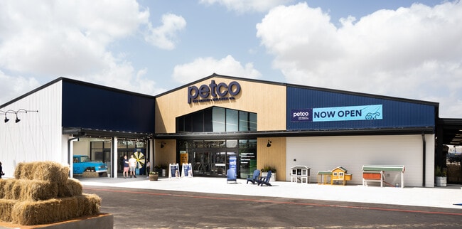
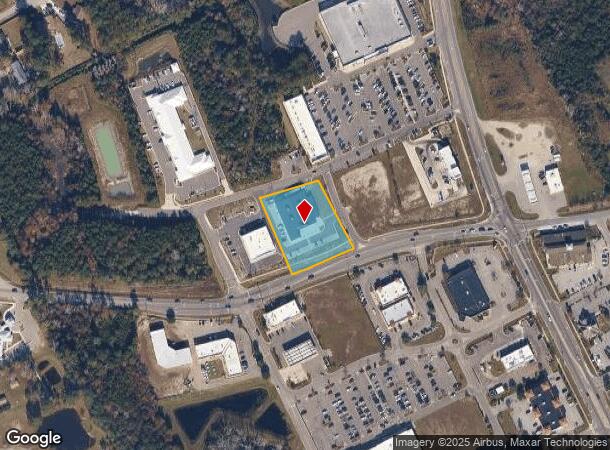
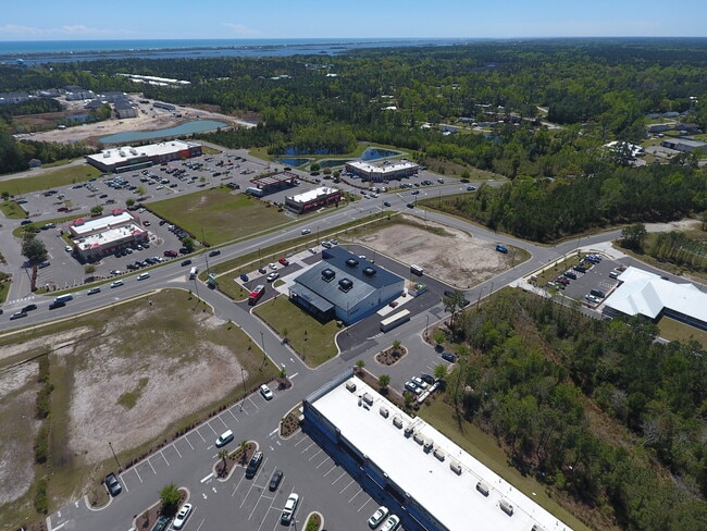
This Property Is For Sale
NEARBY LISTINGS FOR SALE OR LEASE
Property Detail
2737 Nc 210 Hwy E
Wilmington, NC
TR 1 PB 70/27 LOT LINE ADJ FOR SURF CITY TOPSAIL PTNRS LLC
4235-27-5829-0000
Pender
Storebuilding
North Carolina
2024
c
2024
1.22 AC
920105
East Pender County
8,892 SF
Wilmington
DEMOGRAPHICS near 2737 Nc 210 Hwy E
1 Mile
3 Mile
5 Mile
2024 Total Population
2,141
11,565
20,328
2029 Population
2,637
13,955
24,368
Pop Growth 2024-2029
+ 23.17%
+ 20.67%
+ 19.87%
Average Age
41
42
41
2024 Total Households
865
4,725
8,121
HH Growth 2024-2029
+ 23.58%
+ 21.16%
+ 20.28%
Median Household Inc
$60,994
$68,216
$72,098
Avg Household Size
2.40
2.40
2.50
2024 Avg HH Vehicles
2.00
2.00
2.00
Median Home Value
$208,193
$283,587
$298,681
Median Year Built
1994
1998
2001
Nearby Places
- Restaurants
- Banks
- Shops
- Fitness
- Groceries
PUBLIC TRANSPORTATION
AIRPORT
Wilmington International
DRIVE
WALK
Distance
Wilmington International
46 min
29.9 mi
Albert J Ellis
DRIVE
WALK
Distance
Albert J Ellis
58 min
35.8 mi
Freight Ports
Port of Wilmington
DRIVE
WALK
Distance
Port of Wilmington
54 min
31.8 mi
Nearby Properties
Address
Land Use
TOTAL SIZE
Lot Size
Zoning
Address
Land Use
TOTAL SIZE
Lot Size
Zoning
252,960 SF
32.21 AC
SEEMAP
Address
Land Use
TOTAL SIZE
Lot Size
Zoning
6,909 SF
36.97 AC
R-20
Address
Land Use
TOTAL SIZE
Lot Size
Zoning
196,268 SF
1 AC
RP
Address
Land Use
TOTAL SIZE
Lot Size
Zoning
47,280 SF
20 AC
Address
Land Use
TOTAL SIZE
Lot Size
Zoning
138,676 SF
32.99 AC
SEEMAP
Address
Land Use
TOTAL SIZE
Lot Size
Zoning
64,031 SF
9.34 AC
SEEMAP
Address
Land Use
TOTAL SIZE
Lot Size
Zoning
42,092 SF
6.23 AC
SEEMAP
Address
Land Use
TOTAL SIZE
Lot Size
Zoning
1,213.25 AC
R-15
Address
Land Use
TOTAL SIZE
Lot Size
Zoning
27,948 SF
3.13 AC
B2
Address
Land Use
TOTAL SIZE
Lot Size
Zoning
36,000 SF
4.64 AC
B2RA
Address
Land Use
TOTAL SIZE
Lot Size
Zoning
46,080 SF
7.41 AC
Address
Land Use
TOTAL SIZE
Lot Size
Zoning
4.02 AC
R5
Address
Land Use
TOTAL SIZE
Lot Size
Zoning
146.90 AC
SEEMAP
Address
Land Use
TOTAL SIZE
Lot Size
Zoning
8,644 SF
3.10 AC
C1
Address
Land Use
TOTAL SIZE
Lot Size
Zoning
3,088 SF
31.91 AC
R-10A
Address
Land Use
TOTAL SIZE
Lot Size
Zoning
34,996 SF
5.86 AC
SEEMAP
Address
Land Use
TOTAL SIZE
Lot Size
Zoning
900 SF
4.74 AC
C1
Address
Land Use
TOTAL SIZE
Lot Size
Zoning
4,700 SF
13 AC
FA
Address
Land Use
TOTAL SIZE
Lot Size
Zoning
6,500 SF
34.41 AC
SEEMAP
Address
Land Use
TOTAL SIZE
Lot Size
Zoning
13,606 SF
1.52 AC
SEEMAP
Address
Land Use
TOTAL SIZE
Lot Size
Zoning
15,360 SF
0.95 AC
C2
Address
Land Use
TOTAL SIZE
Lot Size
Zoning
7,828 SF
2.89 AC
SEEMAP
Address
Land Use
TOTAL SIZE
Lot Size
Zoning
11,534 SF
2.50 AC
SEEMAP
Address
Land Use
TOTAL SIZE
Lot Size
Zoning
2,035 SF
0.21 AC
Address
Land Use
TOTAL SIZE
Lot Size
Zoning
8,990 SF
1.10 AC
C1
Address
Land Use
TOTAL SIZE
Lot Size
Zoning
1,420 SF
23.59 AC
PD
Address
Land Use
TOTAL SIZE
Lot Size
Zoning
13,482 SF
3.99 AC
SEEMAP
Address
Land Use
TOTAL SIZE
Lot Size
Zoning
9,949 SF
1.14 AC
C2
Address
Land Use
TOTAL SIZE
Lot Size
Zoning
9,237 SF
2.17 AC
SEEMAP
Address
Land Use
TOTAL SIZE
Lot Size
Zoning
4,320 SF
10.40 AC
LI
The World's #1 Commercial Real Estate Marketplace
Connect with us
© 2025 CoStar Group
The information above has been obtained from sources believed reliable. While we do not doubt its accuracy we have not verified it and make no guarantee, warranty or representation about it. It is your responsibility to independently confirm its accuracy and completeness. Any projections, opinions, assumptions, or estimates used are for example only and do not represent the current or future performance of the property. The value of this transaction to you depends on tax and other factors which should be evaluated by your tax, financial, and legal advisors. You and your advisors should conduct a careful, independent investigation of the property to determine to your satisfaction the suitability of the property for your needs.