Property Record
2738 18Th St S, Birmingham, AL 35209
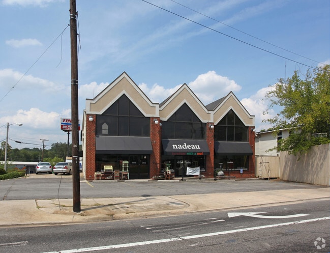
This Property Is For Sale
NEARBY LISTINGS FOR SALE OR LEASE
Property Detail
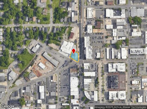
2738 18Th St S
Birmingham-Hoover, AL
South Bham Land Co
28-00-07-3-013-008.000
PT LOTS 13 & 14 BLK 22 SOUTH BHAM LD CO DESC AS FOLS: BEG SW COR OF SD LOT 13 TH NE 95 FT TH SE 49 FT TH SELY 45 FT TO RD R/W TH S ALG RD R/W 90 FT T H SW28 FT TH NW 110 FT TO POB
Bartavern
Jefferson
X
Alabama
01073C0556J
13,14
2023
0.21 AC
2024
Midtown
010702
Birmingham
3,000 SF
DEMOGRAPHICS near 2738 18Th St S
1 Mile
3 Mile
5 Mile
2024 Total Population
12,950
81,689
186,233
2029 Population
12,876
80,946
184,379
Pop Growth 2024-2029
(0.57%)
(0.91%)
(1.00%)
Average Age
33
37
38
2024 Total Households
4,789
36,518
80,928
HH Growth 2024-2029
(0.90%)
(0.72%)
(0.95%)
Median Household Inc
$74,427
$56,762
$55,394
Avg Household Size
2.20
2.00
2.10
2024 Avg HH Vehicles
2.00
2.00
2.00
Median Home Value
$487,474
$435,385
$345,255
Median Year Built
1966
1969
1969
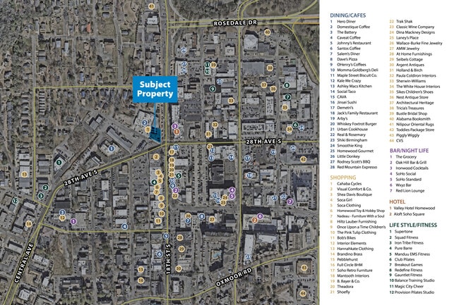
Nearby Places
Map Layers
Map Styles
 Street
 Aerial
- Restaurants
- Banks
- Shops
- Fitness
- Groceries
PUBLIC TRANSPORTATION
COMMUTER RAIL
Birmingham (Crescent - Amtrak)
DRIVE
WALK
Distance
Birmingham (Crescent - Amtrak)
5 min
2.7 mi
AIRPORT
Birmingham-Shuttlesworth International
DRIVE
WALK
Distance
Birmingham-Shuttlesworth International
12 min
7.5 mi
Freight Ports
Port of Mobile
DRIVE
WALK
Distance
Port of Mobile
279 min
253.8 mi
Nearby Properties
Address
Land Use
TOTAL SIZE
Lot Size
Zoning
Address
Land Use
TOTAL SIZE
Lot Size
Zoning
296,284 SF
12 AC
OI
Address
Land Use
TOTAL SIZE
Lot Size
Zoning
305,826 SF
3.68 AC
B4
Address
Land Use
TOTAL SIZE
Lot Size
Zoning
189,447 SF
3.67 AC
B4
Address
Land Use
TOTAL SIZE
Lot Size
Zoning
978,879 SF
43.50 AC
I3
Address
Land Use
TOTAL SIZE
Lot Size
Zoning
239,334 SF
4.42 AC
B6
Address
Land Use
TOTAL SIZE
Lot Size
Zoning
261,311 SF
20.85 AC
C1
Address
Land Use
TOTAL SIZE
Lot Size
Zoning
334,463 SF
1.92 AC
B4
Address
Land Use
TOTAL SIZE
Lot Size
Zoning
106,144 SF
1.09 AC
B4
Address
Land Use
TOTAL SIZE
Lot Size
Zoning
57,066 SF
0.80 AC
B4
Address
Land Use
TOTAL SIZE
Lot Size
Zoning
31,980 SF
99.92 AC
I3/P
Address
Land Use
TOTAL SIZE
Lot Size
Zoning
154,474 SF
12.50 AC
R-D
Address
Land Use
TOTAL SIZE
Lot Size
Zoning
79,458 SF
1.37 AC
B4
Address
Land Use
TOTAL SIZE
Lot Size
Zoning
46,161 SF
1.38 AC
M1-B
Address
Land Use
TOTAL SIZE
Lot Size
Zoning
95,993 SF
3.67 AC
M1
Address
Land Use
TOTAL SIZE
Lot Size
Zoning
229,669 SF
2.75 AC
B4
Address
Land Use
TOTAL SIZE
Lot Size
Zoning
200,927 SF
19 AC
PMUD
Address
Land Use
TOTAL SIZE
Lot Size
Zoning
81,807 SF
6.30 AC
C1
Address
Land Use
TOTAL SIZE
Lot Size
Zoning
109,411 SF
2.77 AC
B4
Address
Land Use
TOTAL SIZE
Lot Size
Zoning
1,666 SF
1.69 AC
M1
Address
Land Use
TOTAL SIZE
Lot Size
Zoning
1.54 AC
B4
Address
Land Use
TOTAL SIZE
Lot Size
Zoning
29,136 SF
1.58 AC
B4
Address
Land Use
TOTAL SIZE
Lot Size
Zoning
37,733 SF
0.84 AC
B-4
Address
Land Use
TOTAL SIZE
Lot Size
Zoning
51,699 SF
1.31 AC
PCD-
Address
Land Use
TOTAL SIZE
Lot Size
Zoning
109,819 SF
2.91 AC
M2
Address
Land Use
TOTAL SIZE
Lot Size
Zoning
37,640 SF
1.76 AC
B4
Address
Land Use
TOTAL SIZE
Lot Size
Zoning
111,309 SF
1.29 AC
B-4
Address
Land Use
TOTAL SIZE
Lot Size
Zoning
32,948 SF
0.48 AC
B3
Address
Land Use
TOTAL SIZE
Lot Size
Zoning
30,453 SF
0.44 AC
B2
Address
Land Use
TOTAL SIZE
Lot Size
Zoning
120,768 SF
1.75 AC
B4
Address
Land Use
TOTAL SIZE
Lot Size
Zoning
329,064 SF
9 AC
I3
The World's #1 Commercial Real Estate Marketplace
Connect with us
© 2025 CoStar Group
The information above has been obtained from sources believed reliable. While we do not doubt its accuracy we have not verified it and make no guarantee, warranty or representation about it. It is your responsibility to independently confirm its accuracy and completeness. Any projections, opinions, assumptions, or estimates used are for example only and do not represent the current or future performance of the property. The value of this transaction to you depends on tax and other factors which should be evaluated by your tax, financial, and legal advisors. You and your advisors should conduct a careful, independent investigation of the property to determine to your satisfaction the suitability of the property for your needs.