Property Record
2738 Underwood Rd Ne, Dalton, GA 30721
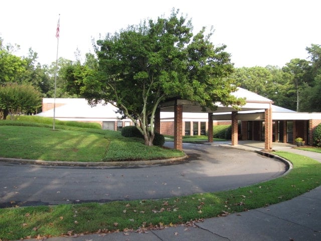

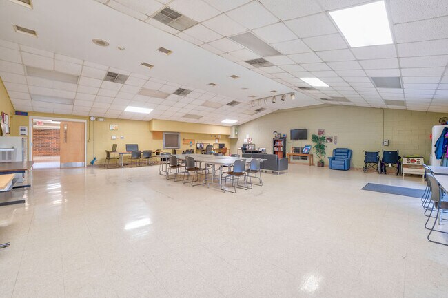
This Property Is For Sale
Property Detail
2738 Underwood Rd Ne
12-176-06-000
6.24A UNDERWOOD RD
Publicschool
Whitfield
B and X Area of moderate flood hazard, usually the area between the limits of the 100-year and 500-year floods.
Georgia
0
6.24 AC
2025
Georgia Northwest
000402
Other Market Areas
28,782 SF
Dalton, GA
NEARBY LISTINGS FOR SALE OR LEASE
DEMOGRAPHICS near 2738 Underwood Rd Ne
1 mile
3 mile
5 mile
2025 Total Population
1,713
32,619
65,249
2030 Population
1,777
33,399
66,928
Pop Growth 2025-2030
+ 3.74%
+ 2.39%
+ 2.57%
Average Age
36
36
38
2025 Total Households
541
10,750
22,564
HH Growth 2025-2030
+ 3.70%
+ 2.42%
+ 2.65%
Median Household Inc
$48,441
$54,069
$59,387
Avg Household Size
3.10
2.90
2.80
2025 Avg HH Vehicles
2.00
2.00
2.00
Median Home Value
$165,769
$192,849
$230,316
Median Year Built
1996
1986
1984
Nearby Places
Map Layers
Map Styles
 Street
 Aerial
Layers
 Traffic
 Biking
Places
Listings with unknown addresses are not visible on the map
- Restaurants
- Banks
- Shops
- Fitness
- Groceries
PUBLIC TRANSPORTATION
AIRPORT
Lovell Field
Drive
Walk
Distance
Lovell Field
42 min
30.1 mi
Nearby Properties
Address
Land Use
TOTAL SIZE
Lot Size
Zoning
Address
Land Use
TOTAL SIZE
Lot Size
Zoning
199,398 SF
37.16 AC
Address
Land Use
TOTAL SIZE
Lot Size
Zoning
784,920 SF
56.60 AC
M-2
Address
Land Use
TOTAL SIZE
Lot Size
Zoning
346,476 SF
31.41 AC
Address
Land Use
TOTAL SIZE
Lot Size
Zoning
195,990 SF
60.25 AC
Address
Land Use
TOTAL SIZE
Lot Size
Zoning
664,020 SF
28.75 AC
M-2
Address
Land Use
TOTAL SIZE
Lot Size
Zoning
100,084 SF
1.47 AC
Address
Land Use
TOTAL SIZE
Lot Size
Zoning
1,188,135 SF
106.61 AC
M2
Address
Land Use
TOTAL SIZE
Lot Size
Zoning
125,756 SF
7 AC
Address
Land Use
TOTAL SIZE
Lot Size
Zoning
29,434 SF
6.36 AC
Address
Land Use
TOTAL SIZE
Lot Size
Zoning
84,200 SF
22.70 AC
Address
Land Use
TOTAL SIZE
Lot Size
Zoning
391,865 SF
17.51 AC
Address
Land Use
TOTAL SIZE
Lot Size
Zoning
219,744 SF
12.74 AC
M-2
Address
Land Use
TOTAL SIZE
Lot Size
Zoning
18,016 SF
27.65 AC
M-2
Address
Land Use
TOTAL SIZE
Lot Size
Zoning
38,016 SF
18 AC
Address
Land Use
TOTAL SIZE
Lot Size
Zoning
127,376 SF
5.64 AC
Address
Land Use
TOTAL SIZE
Lot Size
Zoning
211,512 SF
3.60 AC
M2
Address
Land Use
TOTAL SIZE
Lot Size
Zoning
3,638 SF
117.55 AC
Address
Land Use
TOTAL SIZE
Lot Size
Zoning
193,500 SF
10.95 AC
M-2
Address
Land Use
TOTAL SIZE
Lot Size
Zoning
541,013 SF
21.88 AC
Address
Land Use
TOTAL SIZE
Lot Size
Zoning
151,722 SF
15.17 AC
C2
Address
Land Use
TOTAL SIZE
Lot Size
Zoning
95,840 SF
80.46 AC
Address
Land Use
TOTAL SIZE
Lot Size
Zoning
200,586 SF
18.37 AC
C2
Address
Land Use
TOTAL SIZE
Lot Size
Zoning
45,896 SF
2.22 AC
Address
Land Use
TOTAL SIZE
Lot Size
Zoning
72,430 SF
7.88 AC
Address
Land Use
TOTAL SIZE
Lot Size
Zoning
231,291 SF
23.73 AC
M-2
Address
Land Use
TOTAL SIZE
Lot Size
Zoning
435,487 SF
53.48 AC
M2
Address
Land Use
TOTAL SIZE
Lot Size
Zoning
462,493 SF
43.34 AC
M-2
Address
Land Use
TOTAL SIZE
Lot Size
Zoning
133,852 SF
13.28 AC
C-2
Address
Land Use
TOTAL SIZE
Lot Size
Zoning
21,864 SF
15.25 AC
R-7
Address
Land Use
TOTAL SIZE
Lot Size
Zoning
211,177 SF
13.59 AC
M-2
The World's #1 Commercial Real Estate Marketplace
Connect with us
© 2026 CoStar Group
The information above has been obtained from sources believed reliable. While we do not doubt its accuracy we have not verified it and make no guarantee, warranty or representation about it. It is your responsibility to independently confirm its accuracy and completeness. Any projections, opinions, assumptions, or estimates used are for example only and do not represent the current or future performance of the property. The value of this transaction to you depends on tax and other factors which should be evaluated by your tax, financial, and legal advisors. You and your advisors should conduct a careful, independent investigation of the property to determine to your satisfaction the suitability of the property for your needs.