Property Record
2740 Highway 50, Placerville, CA 95667


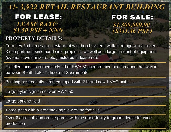

Property Detail
2740 Highway 50
048-520-031-000
RS 14/117/B
Restaurantbuilding
EL DORADO
A
California
B and X Area of moderate flood hazard, usually the area between the limits of the 100-year and 500-year floods.
6.02 AC
2024
Outer El Dorado Cnty
2025
Sacramento
031301
Sacramento-Roseville-Folsom, CA
3,922 SF
NEARBY LISTINGS FOR SALE OR LEASE
DEMOGRAPHICS near 2740 Highway 50
1 mile
3 mile
5 mile
2025 Total Population
698
7,151
22,015
2030 Population
683
7,034
21,656
Pop Growth 2025-2030
(2.15%)
(1.64%)
(1.63%)
Average Age
48
48
46
2025 Total Households
299
3,032
9,180
HH Growth 2025-2030
(2.01%)
(1.55%)
(1.59%)
Median Household Inc
$95,833
$99,971
$90,391
Avg Household Size
2.30
2.30
2.30
2025 Avg HH Vehicles
2.00
2.00
2.00
Median Home Value
$582,644
$628,478
$567,201
Median Year Built
1978
1974
1976
Nearby Places
Map Layers
Map Styles
 Street
 Aerial
Transit
 Traffic
 Biking
Places
Listings with unknown addresses are not visible on the map
- Restaurants
- Banks
- Shops
- Fitness
- Groceries
SALE & LEASE HISTORY
LISTING DATE
SALE/LEASE

Oct 07, 2016
For Sale
Nearby Properties
Address
Land Use
TOTAL SIZE
Lot Size
Zoning
Address
Land Use
TOTAL SIZE
Lot Size
Zoning
55,043 SF
2.57 AC
RE
Address
Land Use
TOTAL SIZE
Lot Size
Zoning
3,072 SF
3.83 AC
Address
Land Use
TOTAL SIZE
Lot Size
Zoning
61,936 SF
8.60 AC
Address
Land Use
TOTAL SIZE
Lot Size
Zoning
25,050 SF
2.08 AC
RE
Address
Land Use
TOTAL SIZE
Lot Size
Zoning
48,440 SF
5.11 AC
Address
Land Use
TOTAL SIZE
Lot Size
Zoning
5,764 SF
4.38 AC
PD
Address
Land Use
TOTAL SIZE
Lot Size
Zoning
261.24 AC
A
Address
Land Use
TOTAL SIZE
Lot Size
Zoning
2,215 SF
0.29 AC
Address
Land Use
TOTAL SIZE
Lot Size
Zoning
28,566 SF
2.14 AC
C
Address
Land Use
TOTAL SIZE
Lot Size
Zoning
36,504 SF
14.90 AC
RE
Address
Land Use
TOTAL SIZE
Lot Size
Zoning
5,795 SF
0.42 AC
C
Address
Land Use
TOTAL SIZE
Lot Size
Zoning
37.46 AC
Address
Land Use
TOTAL SIZE
Lot Size
Zoning
576 SF
3.62 AC
AE
Address
Land Use
TOTAL SIZE
Lot Size
Zoning
18,626 SF
2.38 AC
C
Address
Land Use
TOTAL SIZE
Lot Size
Zoning
18,315 SF
2.47 AC
C
Address
Land Use
TOTAL SIZE
Lot Size
Zoning
2,559 SF
25.29 AC
AE
Address
Land Use
TOTAL SIZE
Lot Size
Zoning
1,150 SF
31.11 AC
A
Address
Land Use
TOTAL SIZE
Lot Size
Zoning
5,911 SF
0.57 AC
C
Address
Land Use
TOTAL SIZE
Lot Size
Zoning
24.51 AC
I
Address
Land Use
TOTAL SIZE
Lot Size
Zoning
1.96 AC
PD
Address
Land Use
TOTAL SIZE
Lot Size
Zoning
9,530 SF
2.38 AC
C
Address
Land Use
TOTAL SIZE
Lot Size
Zoning
8,821 SF
1.03 AC
Address
Land Use
TOTAL SIZE
Lot Size
Zoning
0.68 AC
Address
Land Use
TOTAL SIZE
Lot Size
Zoning
14,044 SF
0.85 AC
C
Address
Land Use
TOTAL SIZE
Lot Size
Zoning
3,999 SF
3.28 AC
MP
Address
Land Use
TOTAL SIZE
Lot Size
Zoning
7,295 SF
0.38 AC
C
Address
Land Use
TOTAL SIZE
Lot Size
Zoning
34,972 SF
3.10 AC
Address
Land Use
TOTAL SIZE
Lot Size
Zoning
1,002 SF
64.60 AC
AE
Address
Land Use
TOTAL SIZE
Lot Size
Zoning
1,581 SF
40.07 AC
AE
The World's #1 Commercial Real Estate Marketplace
Connect with us
© 2026 CoStar Group
The information above has been obtained from sources believed reliable. While we do not doubt its accuracy we have not verified it and make no guarantee, warranty or representation about it. It is your responsibility to independently confirm its accuracy and completeness. Any projections, opinions, assumptions, or estimates used are for example only and do not represent the current or future performance of the property. The value of this transaction to you depends on tax and other factors which should be evaluated by your tax, financial, and legal advisors. You and your advisors should conduct a careful, independent investigation of the property to determine to your satisfaction the suitability of the property for your needs.