Property Record
2740 Nc Highway 71 N, Maxton, NC 28364
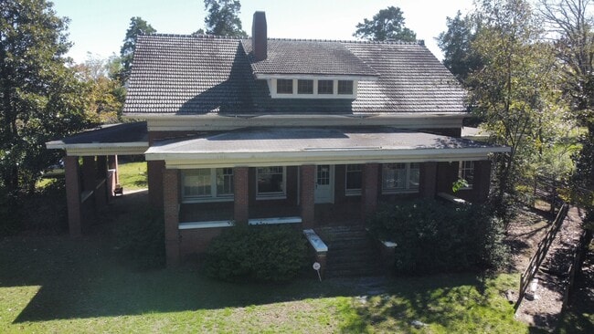
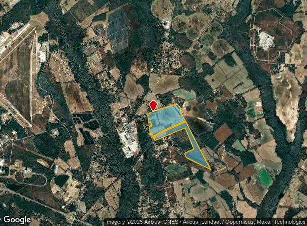

This Property Is For Sale
NEARBY LISTINGS FOR SALE OR LEASE
-
-
View all Maxton listings for sale on LoopNet.com
Property Detail
2740 Nc Highway 71 N
2313-01-024
AC WHITE OAK
Agriculturalland
Robeson
X
North Carolina
3710930700M
288.75 AC
2025
North Carolina Southeast Area
2025
Other Market Areas
960403
Lumberton, NC
3,736 SF
DEMOGRAPHICS near 2740 Nc Highway 71 N
1 Mile
3 Mile
5 Mile
2024 Total Population
587
2,497
9,472
2029 Population
585
2,494
9,449
Pop Growth 2024-2029
(0.34%)
(0.12%)
(0.24%)
Average Age
37
37
39
2024 Total Households
206
878
2,872
HH Growth 2024-2029
0.00%
(0.11%)
(0.21%)
Median Household Inc
$45,208
$41,293
$33,824
Avg Household Size
2.80
2.70
2.60
2024 Avg HH Vehicles
2.00
2.00
2.00
Median Home Value
$64,285
$66,460
$76,887
Median Year Built
1986
1984
1982
Nearby Places
Map Layers
Map Styles
 Street
 Aerial
- Restaurants
- Banks
- Shops
- Fitness
- Groceries
PUBLIC TRANSPORTATION
AIRPORT
Fayetteville Regional/Grannis Field
DRIVE
WALK
Distance
Fayetteville Regional/Grannis Field
49 min
32.3 mi
Freight Ports
Port of Wilmington
DRIVE
WALK
Distance
Port of Wilmington
126 min
102.1 mi
Nearby Properties
Address
Land Use
TOTAL SIZE
Lot Size
Zoning
Address
Land Use
TOTAL SIZE
Lot Size
Zoning
208,125 SF
338.14 AC
I2
Address
Land Use
TOTAL SIZE
Lot Size
Zoning
20,160 SF
32.90 AC
RA
Address
Land Use
TOTAL SIZE
Lot Size
Zoning
4,700 SF
674.45 AC
RA
Address
Land Use
TOTAL SIZE
Lot Size
Zoning
30,860 SF
57.89 AC
I2
Address
Land Use
TOTAL SIZE
Lot Size
Zoning
4,272 SF
8.09 AC
RA
Address
Land Use
TOTAL SIZE
Lot Size
Zoning
50,120 SF
31.30 AC
RA
Address
Land Use
TOTAL SIZE
Lot Size
Zoning
28,090 SF
3.96 AC
HB
Address
Land Use
TOTAL SIZE
Lot Size
Zoning
3,608 SF
119.04 AC
RA
Address
Land Use
TOTAL SIZE
Lot Size
Zoning
673.62 AC
RA
Address
Land Use
TOTAL SIZE
Lot Size
Zoning
24,808 SF
3.87 AC
R12
Address
Land Use
TOTAL SIZE
Lot Size
Zoning
245.80 AC
RA
Address
Land Use
TOTAL SIZE
Lot Size
Zoning
458.79 AC
RA
Address
Land Use
TOTAL SIZE
Lot Size
Zoning
2,112 SF
21.42 AC
RA
Address
Land Use
TOTAL SIZE
Lot Size
Zoning
12,360 SF
7.66 AC
HB
Address
Land Use
TOTAL SIZE
Lot Size
Zoning
9,936 SF
3.71 AC
Address
Land Use
TOTAL SIZE
Lot Size
Zoning
9,045 SF
2.03 AC
Address
Land Use
TOTAL SIZE
Lot Size
Zoning
9,360 SF
91.61 AC
Address
Land Use
TOTAL SIZE
Lot Size
Zoning
11,600 SF
3.74 AC
H1
Address
Land Use
TOTAL SIZE
Lot Size
Zoning
8,658 SF
11.66 AC
RA
Address
Land Use
TOTAL SIZE
Lot Size
Zoning
5,429 SF
163.88 AC
RA20
Address
Land Use
TOTAL SIZE
Lot Size
Zoning
3,440 SF
2.19 AC
HB
Address
Land Use
TOTAL SIZE
Lot Size
Zoning
7,205 SF
3 AC
RA
Address
Land Use
TOTAL SIZE
Lot Size
Zoning
6,026 SF
21.80 AC
I
Address
Land Use
TOTAL SIZE
Lot Size
Zoning
6,105 SF
1 AC
RA20
Address
Land Use
TOTAL SIZE
Lot Size
Zoning
455 AC
RA
Address
Land Use
TOTAL SIZE
Lot Size
Zoning
71.50 AC
Address
Land Use
TOTAL SIZE
Lot Size
Zoning
2,475 SF
40.28 AC
RA
Address
Land Use
TOTAL SIZE
Lot Size
Zoning
1,750 SF
599.93 AC
RA
Address
Land Use
TOTAL SIZE
Lot Size
Zoning
1,500 SF
212 AC
RA
Address
Land Use
TOTAL SIZE
Lot Size
Zoning
1,708 SF
11.23 AC
RA
The World's #1 Commercial Real Estate Marketplace
Connect with us
© 2026 CoStar Group
The information above has been obtained from sources believed reliable. While we do not doubt its accuracy we have not verified it and make no guarantee, warranty or representation about it. It is your responsibility to independently confirm its accuracy and completeness. Any projections, opinions, assumptions, or estimates used are for example only and do not represent the current or future performance of the property. The value of this transaction to you depends on tax and other factors which should be evaluated by your tax, financial, and legal advisors. You and your advisors should conduct a careful, independent investigation of the property to determine to your satisfaction the suitability of the property for your needs.