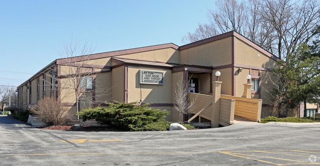
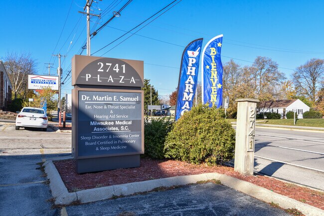
Property Record
2741 W Layton Ave, Milwaukee, WI 53221


NEARBY LISTINGS FOR SALE OR LEASE
Property Detail
2741 W Layton Ave
622-9986-001
2741 W LAYTON AV W 120 FT OF E 370 FT OF N 346.50 FT OF NE 25 6 21 EXC 65 FT OF W 60 FT THEREOF & E N 60 FT OF E 60 FT THEREOF F AVE
Commercialnec
Milwaukee
X
Wisconsin
55079C0154E
0.79 AC
2023
Milwaukee Near SW
2024
Milwaukee/Madison
120502
Milwaukee-Waukesha-West Allis, WI
7,984 SF
DEMOGRAPHICS near 2741 W Layton Ave
1 Mile
3 Mile
5 Mile
2024 Total Population
11,961
118,359
322,939
2029 Population
11,552
115,125
314,682
Pop Growth 2024-2029
(3.42%)
(2.73%)
(2.56%)
Average Age
40
39
39
2024 Total Households
5,040
47,842
132,132
HH Growth 2024-2029
(3.59%)
(2.80%)
(2.60%)
Median Household Inc
$53,271
$61,985
$59,335
Avg Household Size
2.30
2.40
2.40
2024 Avg HH Vehicles
2.00
2.00
2.00
Median Home Value
$226,570
$185,865
$192,367
Median Year Built
1967
1959
1955
Nearby Places
Map Layers
Map Styles
 Street
 Aerial
- Restaurants
- Banks
- Shops
- Fitness
- Groceries
PUBLIC TRANSPORTATION
COMMUTER RAIL
DRIVE
WALK
Distance
8 min
3.0 mi
DRIVE
WALK
Distance
12 min
7.5 mi
AIRPORT
General Mitchell International
DRIVE
WALK
Distance
General Mitchell International
8 min
3.2 mi
Freight Ports
Port Milwaukee
DRIVE
WALK
Distance
Port Milwaukee
9 min
5.4 mi
SALE & LEASE HISTORY
LISTING DATE
SALE/LEASE

Sep 23, 2016
For Sale
Oct 18, 2016
For Sale
May 09, 2017
For Sale
Jun 30, 2021
For Lease
Jan 26, 2017
For Sale
Dec 22, 2020
For Sale
Nearby Properties
Address
Land Use
TOTAL SIZE
Lot Size
Zoning
Address
Land Use
TOTAL SIZE
Lot Size
Zoning
19.92 AC
Address
Land Use
TOTAL SIZE
Lot Size
Zoning
48.34 AC
IO1
Address
Land Use
TOTAL SIZE
Lot Size
Zoning
197,354 SF
18 AC
CS
Address
Land Use
TOTAL SIZE
Lot Size
Zoning
23.09 AC
Address
Land Use
TOTAL SIZE
Lot Size
Zoning
188,328 SF
22.41 AC
PD
Address
Land Use
TOTAL SIZE
Lot Size
Zoning
17.47 AC
R2
Address
Land Use
TOTAL SIZE
Lot Size
Zoning
Address
Land Use
TOTAL SIZE
Lot Size
Zoning
262,150 SF
14.62 AC
PUDR5
Address
Land Use
TOTAL SIZE
Lot Size
Zoning
238,201 SF
17.96 AC
PUDR5
Address
Land Use
TOTAL SIZE
Lot Size
Zoning
228,912 SF
16.77 AC
Address
Land Use
TOTAL SIZE
Lot Size
Zoning
Address
Land Use
TOTAL SIZE
Lot Size
Zoning
20.61 AC
TL
Address
Land Use
TOTAL SIZE
Lot Size
Zoning
21.72 AC
RESIDENTIA
Address
Land Use
TOTAL SIZE
Lot Size
Zoning
162,138 SF
9.15 AC
PD
Address
Land Use
TOTAL SIZE
Lot Size
Zoning
213,964 SF
13.94 AC
PUDR5
Address
Land Use
TOTAL SIZE
Lot Size
Zoning
132,289 SF
5.34 AC
PD
Address
Land Use
TOTAL SIZE
Lot Size
Zoning
13.84 AC
Address
Land Use
TOTAL SIZE
Lot Size
Zoning
360,000 SF
14.60 AC
IL1
Address
Land Use
TOTAL SIZE
Lot Size
Zoning
20.49 AC
TL
Address
Land Use
TOTAL SIZE
Lot Size
Zoning
4.27 AC
Address
Land Use
TOTAL SIZE
Lot Size
Zoning
11.33 AC
Address
Land Use
TOTAL SIZE
Lot Size
Zoning
152,130 SF
7.68 AC
PD
Address
Land Use
TOTAL SIZE
Lot Size
Zoning
130,723 SF
12.94 AC
C2
Address
Land Use
TOTAL SIZE
Lot Size
Zoning
205,632 SF
18 AC
PD
Address
Land Use
TOTAL SIZE
Lot Size
Zoning
156,753 SF
12.28 AC
LB1
Address
Land Use
TOTAL SIZE
Lot Size
Zoning
94.05 AC
PK
Address
Land Use
TOTAL SIZE
Lot Size
Zoning
85,264 SF
3.67 AC
PD
Address
Land Use
TOTAL SIZE
Lot Size
Zoning
Address
Land Use
TOTAL SIZE
Lot Size
Zoning
4.16 AC
Address
Land Use
TOTAL SIZE
Lot Size
Zoning
10.43 AC
The World's #1 Commercial Real Estate Marketplace
Connect with us
© 2025 CoStar Group
The information above has been obtained from sources believed reliable. While we do not doubt its accuracy we have not verified it and make no guarantee, warranty or representation about it. It is your responsibility to independently confirm its accuracy and completeness. Any projections, opinions, assumptions, or estimates used are for example only and do not represent the current or future performance of the property. The value of this transaction to you depends on tax and other factors which should be evaluated by your tax, financial, and legal advisors. You and your advisors should conduct a careful, independent investigation of the property to determine to your satisfaction the suitability of the property for your needs.