Property Record
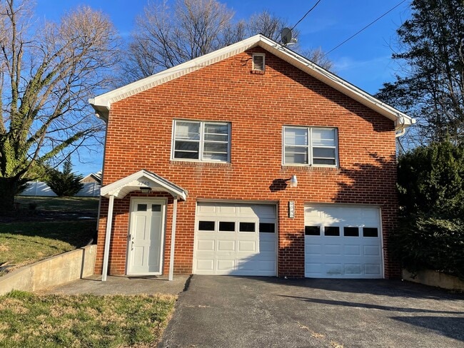
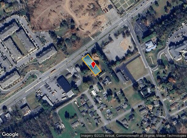
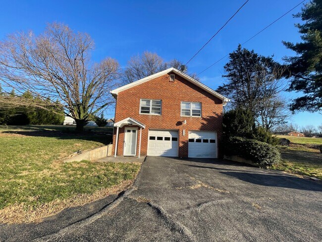
2745 Orange Ave Ne, Roanoke, VA 24012
This Property Is For Sale
NEARBY LISTINGS FOR SALE OR LEASE
Property Detail
2745 Orange Ave Ne
Roanoke, VA
Gary Spencer Peters
707-0113
Roanoke City
Sfr
Virginia
X
0.38 AC
51161C0167G
Southeast Roanoke
854 SF
Roanoke
DEMOGRAPHICS near 2745 Orange Ave Ne
1 Mile
3 Mile
5 Mile
2024 Total Population
5,880
54,550
113,812
2029 Population
5,848
53,849
112,519
Pop Growth 2024-2029
(0.54%)
(1.29%)
(1.14%)
Average Age
39
40
41
2024 Total Households
2,743
23,237
49,115
HH Growth 2024-2029
(0.58%)
(1.26%)
(1.20%)
Median Household Inc
$48,637
$52,183
$52,773
Avg Household Size
2.10
2.30
2.20
2024 Avg HH Vehicles
2.00
2.00
2.00
Median Home Value
$144,214
$168,930
$183,063
Median Year Built
1977
1968
1965
Nearby Places
- Restaurants
- Banks
- Shops
- Fitness
- Groceries
PUBLIC TRANSPORTATION
COMMUTER RAIL
Roanoke (Northeast Regional - Amtrak)
DRIVE
WALK
Distance
Roanoke (Northeast Regional - Amtrak)
7 min
3.5 mi
AIRPORT
Roanoke/Blacksburg Regional (Woodrum Field)
DRIVE
WALK
Distance
Roanoke/Blacksburg Regional (Woodrum Field)
14 min
6.6 mi
Freight Ports
Virginia Port Authority - Richmond
DRIVE
WALK
Distance
Virginia Port Authority - Richmond
211 min
158.7 mi
Nearby Properties
Address
Land Use
TOTAL SIZE
Lot Size
Zoning
Address
Land Use
TOTAL SIZE
Lot Size
Zoning
370 SF
105.25 AC
I-2
Address
Land Use
TOTAL SIZE
Lot Size
Zoning
476,613 SF
5.29 AC
D
Address
Land Use
TOTAL SIZE
Lot Size
Zoning
214,543 SF
38.29 AC
R1S
Address
Land Use
TOTAL SIZE
Lot Size
Zoning
96,620 SF
26.84 AC
D
Address
Land Use
TOTAL SIZE
Lot Size
Zoning
87,406 SF
1.15 AC
D
Address
Land Use
TOTAL SIZE
Lot Size
Zoning
3,404 SF
17.41 AC
MXPUD
Address
Land Use
TOTAL SIZE
Lot Size
Zoning
262,715 SF
5.09 AC
D
Address
Land Use
TOTAL SIZE
Lot Size
Zoning
71,696 SF
71.64 AC
INPUD/ROS
Address
Land Use
TOTAL SIZE
Lot Size
Zoning
1.25 AC
D
Address
Land Use
TOTAL SIZE
Lot Size
Zoning
81,500 SF
0.63 AC
D
Address
Land Use
TOTAL SIZE
Lot Size
Zoning
12,220 SF
5.09 AC
D
Address
Land Use
TOTAL SIZE
Lot Size
Zoning
150,151 SF
0.84 AC
D
Address
Land Use
TOTAL SIZE
Lot Size
Zoning
33,249 SF
5.50 AC
D
Address
Land Use
TOTAL SIZE
Lot Size
Zoning
24,126 SF
20.11 AC
R3
Address
Land Use
TOTAL SIZE
Lot Size
Zoning
206,418 SF
1.50 AC
D
Address
Land Use
TOTAL SIZE
Lot Size
Zoning
67,486 SF
3.99 AC
RMF
Address
Land Use
TOTAL SIZE
Lot Size
Zoning
238,125 SF
0.37 AC
D
Address
Land Use
TOTAL SIZE
Lot Size
Zoning
160,537 SF
11.08 AC
I-1
Address
Land Use
TOTAL SIZE
Lot Size
Zoning
402,320 SF
42.13 AC
I1C
Address
Land Use
TOTAL SIZE
Lot Size
Zoning
387,684 SF
27.44 AC
I-1
Address
Land Use
TOTAL SIZE
Lot Size
Zoning
142,048 SF
21.38 AC
I-1
Address
Land Use
TOTAL SIZE
Lot Size
Zoning
2,193 SF
2,914.16 AC
AG3
Address
Land Use
TOTAL SIZE
Lot Size
Zoning
92,235 SF
0.49 AC
D
Address
Land Use
TOTAL SIZE
Lot Size
Zoning
609,211 SF
41.01 AC
I1C
Address
Land Use
TOTAL SIZE
Lot Size
Zoning
29.63 AC
I-1
Address
Land Use
TOTAL SIZE
Lot Size
Zoning
14,418 SF
11.15 AC
RMF
Address
Land Use
TOTAL SIZE
Lot Size
Zoning
10,704 SF
12.76 AC
D
Address
Land Use
TOTAL SIZE
Lot Size
Zoning
96,650 SF
0.84 AC
D
Address
Land Use
TOTAL SIZE
Lot Size
Zoning
57,985 SF
12.66 AC
R1
Address
Land Use
TOTAL SIZE
Lot Size
Zoning
11,694 SF
12.05 AC
RMF
The World's #1 Commercial Real Estate Marketplace
Connect with us
© 2025 CoStar Group
The information above has been obtained from sources believed reliable. While we do not doubt its accuracy we have not verified it and make no guarantee, warranty or representation about it. It is your responsibility to independently confirm its accuracy and completeness. Any projections, opinions, assumptions, or estimates used are for example only and do not represent the current or future performance of the property. The value of this transaction to you depends on tax and other factors which should be evaluated by your tax, financial, and legal advisors. You and your advisors should conduct a careful, independent investigation of the property to determine to your satisfaction the suitability of the property for your needs.