Property Record
275 37Th St Ne, Rochester, MN 55906


NEARBY LISTINGS FOR SALE OR LEASE
Property Detail
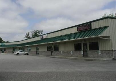
275 37Th St Ne
74.23.14.051458
City Lands 107-14-23
Stripcommercialcenter
SECT-23 TWP-107 RANGE-014 CITY LANDS 107-14-23 2.01 AC ALL TH PT S12 NE14 WH LIES NLY OF CEN- LINE 37TH ST NW AND WLY OF FOL
X
Olmsted
27109C0162F
Minnesota
2025
0.94 AC
2024
Rochester
001603
Other Market Areas
11,448 SF
Rochester, MN
DEMOGRAPHICS near 275 37Th St Ne
1 Mile
3 Mile
5 Mile
2024 Total Population
6,720
59,822
115,937
2029 Population
6,846
61,127
118,967
Pop Growth 2024-2029
+ 1.88%
+ 2.18%
+ 2.61%
Average Age
40
40
39
2024 Total Households
2,777
26,111
47,962
HH Growth 2024-2029
+ 1.80%
+ 2.31%
+ 2.64%
Median Household Inc
$83,434
$72,828
$79,264
Avg Household Size
2.30
2.20
2.30
2024 Avg HH Vehicles
2.00
2.00
2.00
Median Home Value
$268,350
$266,163
$273,662
Median Year Built
1981
1980
1985
Nearby Places
Map Layers
Map Styles
 Street
 Aerial
- Restaurants
- Banks
- Shops
- Fitness
- Groceries
PUBLIC TRANSPORTATION
AIRPORT
Rochester International
DRIVE
WALK
Distance
Rochester International
19 min
12.9 mi
Freight Ports
Port Milwaukee
DRIVE
WALK
Distance
Port Milwaukee
311 min
279.5 mi
SALE & LEASE HISTORY
LISTING DATE
SALE/LEASE

Sep 17, 2021
For Lease
Oct 22, 2021
For Sale
May 26, 2017
For Lease
Mar 13, 2018
For Lease
Mar 10, 2020
For Sale
Jul 22, 2019
For Lease
Aug 30, 2017
For Lease
Apr 28, 2025
For Lease
Apr 26, 2023
For Lease
Nearby Properties
Address
Land Use
TOTAL SIZE
Lot Size
Zoning
Address
Land Use
TOTAL SIZE
Lot Size
Zoning
2,238,362 SF
2.06 AC
Address
Land Use
TOTAL SIZE
Lot Size
Zoning
791,669 SF
2.15 AC
Address
Land Use
TOTAL SIZE
Lot Size
Zoning
37,242 SF
1.06 AC
Address
Land Use
TOTAL SIZE
Lot Size
Zoning
454,243 SF
3.92 AC
Address
Land Use
TOTAL SIZE
Lot Size
Zoning
443,223 SF
4.44 AC
Address
Land Use
TOTAL SIZE
Lot Size
Zoning
448,296 SF
1.21 AC
Address
Land Use
TOTAL SIZE
Lot Size
Zoning
960 SF
38.12 AC
Address
Land Use
TOTAL SIZE
Lot Size
Zoning
45.84 AC
Address
Land Use
TOTAL SIZE
Lot Size
Zoning
1,836 SF
80.90 AC
Address
Land Use
TOTAL SIZE
Lot Size
Zoning
339,724 SF
0.56 AC
Address
Land Use
TOTAL SIZE
Lot Size
Zoning
0.88 AC
Address
Land Use
TOTAL SIZE
Lot Size
Zoning
13,946 SF
34.10 AC
Address
Land Use
TOTAL SIZE
Lot Size
Zoning
309,127 SF
0.67 AC
Address
Land Use
TOTAL SIZE
Lot Size
Zoning
175,078 SF
1.98 AC
Address
Land Use
TOTAL SIZE
Lot Size
Zoning
98,878 SF
0.89 AC
Address
Land Use
TOTAL SIZE
Lot Size
Zoning
159,238 SF
0.65 AC
Address
Land Use
TOTAL SIZE
Lot Size
Zoning
423,328 SF
1.89 AC
Address
Land Use
TOTAL SIZE
Lot Size
Zoning
192,929 SF
1.12 AC
Address
Land Use
TOTAL SIZE
Lot Size
Zoning
Address
Land Use
TOTAL SIZE
Lot Size
Zoning
61,632 SF
53.25 AC
Address
Land Use
TOTAL SIZE
Lot Size
Zoning
53.73 AC
Address
Land Use
TOTAL SIZE
Lot Size
Zoning
167.09 AC
Address
Land Use
TOTAL SIZE
Lot Size
Zoning
4.63 AC
Address
Land Use
TOTAL SIZE
Lot Size
Zoning
250,864 SF
4.43 AC
Address
Land Use
TOTAL SIZE
Lot Size
Zoning
9.01 AC
Address
Land Use
TOTAL SIZE
Lot Size
Zoning
122,460 SF
0.33 AC
Address
Land Use
TOTAL SIZE
Lot Size
Zoning
6,780 SF
1.16 AC
Address
Land Use
TOTAL SIZE
Lot Size
Zoning
136,031 SF
35.28 AC
Address
Land Use
TOTAL SIZE
Lot Size
Zoning
170,843 SF
13.66 AC
Address
Land Use
TOTAL SIZE
Lot Size
Zoning
199,348 SF
2.89 AC
The World's #1 Commercial Real Estate Marketplace
Connect with us
© 2026 CoStar Group
The information above has been obtained from sources believed reliable. While we do not doubt its accuracy we have not verified it and make no guarantee, warranty or representation about it. It is your responsibility to independently confirm its accuracy and completeness. Any projections, opinions, assumptions, or estimates used are for example only and do not represent the current or future performance of the property. The value of this transaction to you depends on tax and other factors which should be evaluated by your tax, financial, and legal advisors. You and your advisors should conduct a careful, independent investigation of the property to determine to your satisfaction the suitability of the property for your needs.