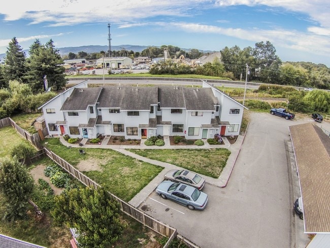
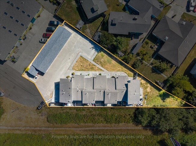
Property Record
275 9Th St, Fortuna, CA 95540


Save to a Folder
{{folder.Name}}
{{folder.ListingIds.length}} Properties
{{folder.ListingIds.length}} Property
Create a New Folder
Property Detail
275 9Th St
040-192-002-000
SUB: 2429, PARCEL MAP PLAT BOOK: P21 PLAT PAGE: 107 LOT: 2
Multifamilydwelling
Humboldt
RM
California
B and X Area of moderate flood hazard, usually the area between the limits of the 100-year and 500-year floods.
2
2024
0.41 AC
2025
Eureka/Crescent City
010800
Other Market Areas
7,056 SF
Eureka-Arcata, CA
NEARBY LISTINGS FOR SALE OR LEASE
-
-
View all Fortuna listings for sale on LoopNet.com
DEMOGRAPHICS near 275 9Th St
1 mile
3 mile
5 mile
2025 Total Population
5,475
14,076
16,535
2030 Population
5,410
13,880
16,146
Pop Growth 2025-2030
(1.19%)
(1.39%)
(2.35%)
Average Age
41
42
42
2025 Total Households
2,216
5,575
6,557
HH Growth 2025-2030
(1.22%)
(1.51%)
(2.50%)
Median Household Inc
$63,151
$68,278
$69,495
Avg Household Size
2.40
2.50
2.50
2025 Avg HH Vehicles
2.00
2.00
2.00
Median Home Value
$385,538
$434,677
$456,074
Median Year Built
1973
1976
1976
Nearby Places
Map Layers
Map Styles
 Street
 Aerial
Layers
 Traffic
 Biking
Places
Listings with unknown addresses are not visible on the map
- Restaurants
- Banks
- Shops
- Fitness
- Groceries
PUBLIC TRANSPORTATION
AIRPORT
California Redwood Coast-Humboldt County
Drive
Walk
Distance
California Redwood Coast-Humboldt County
51 min
34.4 mi
Freight Ports
Port of Coos Bay, OR
Drive
Walk
Distance
Port of Coos Bay, OR
317 min
234.5 mi
SALE & LEASE HISTORY
LISTING DATE
SALE/LEASE

Sep 24, 2016
For Sale
Sep 15, 2025
For Sale
Nearby Properties
Address
Land Use
TOTAL SIZE
Lot Size
Zoning
Address
Land Use
TOTAL SIZE
Lot Size
Zoning
34,592 SF
7.01 AC
PF
Address
Land Use
TOTAL SIZE
Lot Size
Zoning
27.39 AC
Address
Land Use
TOTAL SIZE
Lot Size
Zoning
5.19 AC
PF,RM
Address
Land Use
TOTAL SIZE
Lot Size
Zoning
10,542 SF
1.72 AC
FC
Address
Land Use
TOTAL SIZE
Lot Size
Zoning
33,961 SF
3.97 AC
RM
Address
Land Use
TOTAL SIZE
Lot Size
Zoning
5.05 AC
MG/F,R
Address
Land Use
TOTAL SIZE
Lot Size
Zoning
1.83 AC
RM
Address
Land Use
TOTAL SIZE
Lot Size
Zoning
1.41 AC
CT-QD
Address
Land Use
TOTAL SIZE
Lot Size
Zoning
20,902 SF
1.03 AC
FC
Address
Land Use
TOTAL SIZE
Lot Size
Zoning
6.01 AC
CT
Address
Land Use
TOTAL SIZE
Lot Size
Zoning
2.55 AC
CT
Address
Land Use
TOTAL SIZE
Lot Size
Zoning
3.01 AC
RM
Address
Land Use
TOTAL SIZE
Lot Size
Zoning
2.06 AC
CT
Address
Land Use
TOTAL SIZE
Lot Size
Zoning
33,160 SF
1.03 AC
FC
Address
Land Use
TOTAL SIZE
Lot Size
Zoning
Address
Land Use
TOTAL SIZE
Lot Size
Zoning
1.34 AC
FC
Address
Land Use
TOTAL SIZE
Lot Size
Zoning
1.87 AC
CT-QD
Address
Land Use
TOTAL SIZE
Lot Size
Zoning
1.58 AC
ML-B-5
Address
Land Use
TOTAL SIZE
Lot Size
Zoning
7.32 AC
FC
Address
Land Use
TOTAL SIZE
Lot Size
Zoning
200 SF
7.04 AC
CR/F
Address
Land Use
TOTAL SIZE
Lot Size
Zoning
2.02 AC
RM
Address
Land Use
TOTAL SIZE
Lot Size
Zoning
27,004 SF
3.28 AC
PF
Address
Land Use
TOTAL SIZE
Lot Size
Zoning
1.89 AC
R-1-6
Address
Land Use
TOTAL SIZE
Lot Size
Zoning
27,820 SF
1.95 AC
PF
Address
Land Use
TOTAL SIZE
Lot Size
Zoning
1.57 AC
RM
Address
Land Use
TOTAL SIZE
Lot Size
Zoning
876 SF
199.57 AC
AE-60/FRT;
The World's #1 Commercial Real Estate Marketplace
Connect with us
© 2026 CoStar Group
The information above has been obtained from sources believed reliable. While we do not doubt its accuracy we have not verified it and make no guarantee, warranty or representation about it. It is your responsibility to independently confirm its accuracy and completeness. Any projections, opinions, assumptions, or estimates used are for example only and do not represent the current or future performance of the property. The value of this transaction to you depends on tax and other factors which should be evaluated by your tax, financial, and legal advisors. You and your advisors should conduct a careful, independent investigation of the property to determine to your satisfaction the suitability of the property for your needs.