Property Record
275 Anchor Dr, Moneta, VA 24121

NEARBY LISTINGS FOR SALE OR LEASE
-
-
View all Moneta listings for sale on LoopNet.com
Property Detail
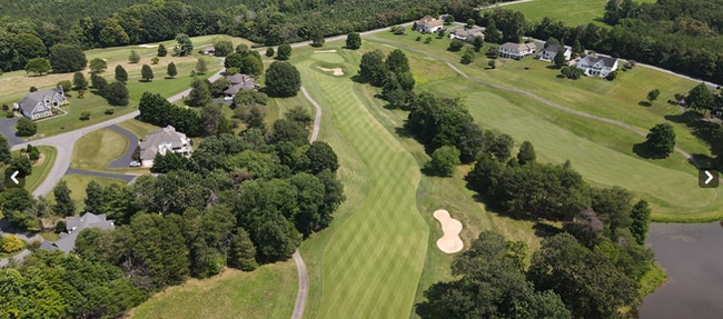
275 Anchor Dr
0310405200
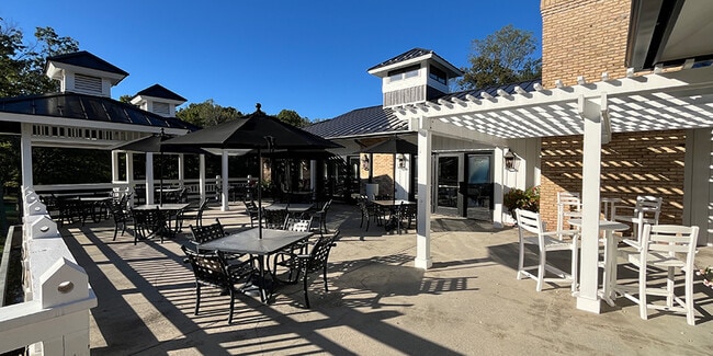
The Water Fron
Restaurantbuilding
THE WATER FRONT GOLF COURSE-PARCELS 2-5
AE
Franklin
51019C0535D
Virginia
2025
106 AC
2025
North Franklin County
020104
Roanoke
13,830 SF
Roanoke, VA
DEMOGRAPHICS near 275 Anchor Dr
1 Mile
3 Mile
5 Mile
2024 Total Population
1,206
6,229
13,877
2029 Population
1,302
6,725
14,908
Pop Growth 2024-2029
+ 7.96%
+ 7.96%
+ 7.43%
Average Age
55
54
54
2024 Total Households
578
2,922
6,399
HH Growth 2024-2029
+ 7.96%
+ 7.94%
+ 7.42%
Median Household Inc
$106,801
$97,835
$91,466
Avg Household Size
2.00
2.10
2.10
2024 Avg HH Vehicles
2.00
2.00
2.00
Median Home Value
$533,929
$538,643
$528,807
Median Year Built
1986
1989
1991
Nearby Places
Map Layers
Map Styles
 Street
 Aerial
- Restaurants
- Banks
- Shops
- Fitness
- Groceries
PUBLIC TRANSPORTATION
AIRPORT
Roanoke/Blacksburg Regional (Woodrum Field)
DRIVE
WALK
Distance
Roanoke/Blacksburg Regional (Woodrum Field)
55 min
33.3 mi
Lynchburg Regional/Preston Glenn Field
DRIVE
WALK
Distance
Lynchburg Regional/Preston Glenn Field
70 min
45.5 mi
Freight Ports
Virginia Port Authority - Richmond
DRIVE
WALK
Distance
Virginia Port Authority - Richmond
219 min
159.1 mi
Nearby Properties
Address
Land Use
TOTAL SIZE
Lot Size
Zoning
Address
Land Use
TOTAL SIZE
Lot Size
Zoning
7,228 SF
8.50 AC
PCD
Address
Land Use
TOTAL SIZE
Lot Size
Zoning
588.45 AC
SM
Address
Land Use
TOTAL SIZE
Lot Size
Zoning
165 AC
A1
Address
Land Use
TOTAL SIZE
Lot Size
Zoning
41,054 SF
12.91 AC
B2
Address
Land Use
TOTAL SIZE
Lot Size
Zoning
13.19 AC
Address
Land Use
TOTAL SIZE
Lot Size
Zoning
Address
Land Use
TOTAL SIZE
Lot Size
Zoning
21,703 SF
6.34 AC
A1
Address
Land Use
TOTAL SIZE
Lot Size
Zoning
Address
Land Use
TOTAL SIZE
Lot Size
Zoning
21,360 SF
3.76 AC
PCD
Address
Land Use
TOTAL SIZE
Lot Size
Zoning
1,168 SF
31.50 AC
Address
Land Use
TOTAL SIZE
Lot Size
Zoning
39.36 AC
RPD
Address
Land Use
TOTAL SIZE
Lot Size
Zoning
4.51 AC
A1
Address
Land Use
TOTAL SIZE
Lot Size
Zoning
4,450 SF
5.76 AC
RPD
Address
Land Use
TOTAL SIZE
Lot Size
Zoning
2,784 SF
78.60 AC
Address
Land Use
TOTAL SIZE
Lot Size
Zoning
0.88 AC
R1
Address
Land Use
TOTAL SIZE
Lot Size
Zoning
0.68 AC
RPD
Address
Land Use
TOTAL SIZE
Lot Size
Zoning
4,708 SF
1.16 AC
B2
Address
Land Use
TOTAL SIZE
Lot Size
Zoning
1.50 AC
PCD
Address
Land Use
TOTAL SIZE
Lot Size
Zoning
29.16 AC
B2
Address
Land Use
TOTAL SIZE
Lot Size
Zoning
8,014 SF
11.89 AC
A1
Address
Land Use
TOTAL SIZE
Lot Size
Zoning
3,008 SF
6.27 AC
B2
Address
Land Use
TOTAL SIZE
Lot Size
Zoning
3,075 SF
3.46 AC
B2
Address
Land Use
TOTAL SIZE
Lot Size
Zoning
2,320 SF
6.13 AC
R1
Address
Land Use
TOTAL SIZE
Lot Size
Zoning
3.39 AC
B2
Address
Land Use
TOTAL SIZE
Lot Size
Zoning
89.10 AC
A1
Address
Land Use
TOTAL SIZE
Lot Size
Zoning
4,220 SF
1.56 AC
PCD
Address
Land Use
TOTAL SIZE
Lot Size
Zoning
9,100 SF
1 AC
B2
Address
Land Use
TOTAL SIZE
Lot Size
Zoning
1,352 SF
2.04 AC
B2
Address
Land Use
TOTAL SIZE
Lot Size
Zoning
112.01 AC
SM
The World's #1 Commercial Real Estate Marketplace
Connect with us
© 2025 CoStar Group
The information above has been obtained from sources believed reliable. While we do not doubt its accuracy we have not verified it and make no guarantee, warranty or representation about it. It is your responsibility to independently confirm its accuracy and completeness. Any projections, opinions, assumptions, or estimates used are for example only and do not represent the current or future performance of the property. The value of this transaction to you depends on tax and other factors which should be evaluated by your tax, financial, and legal advisors. You and your advisors should conduct a careful, independent investigation of the property to determine to your satisfaction the suitability of the property for your needs.