Property Record
275 Jenness Pond Rd, Northwood, NH 03261


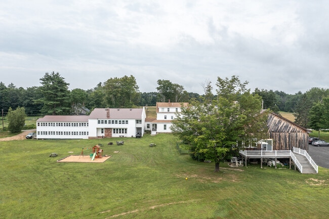
This Property Is For Sale
NEARBY LISTINGS FOR SALE OR LEASE
-
-
View all Northwood listings for sale on LoopNet.com
Property Detail
275 Jenness Pond Rd
NWOO-000203-000000-000002
Rockingham
Commercialnec
New Hampshire
X
2
33013C0415E
5.03 AC
2024
Concord/New Hampshire North Area
2024
Boston
057000
Boston-Cambridge-Newton, MA-NH
19,587 SF
DEMOGRAPHICS near 275 Jenness Pond Rd
1 Mile
3 Mile
5 Mile
2024 Total Population
468
3,708
9,125
2029 Population
492
3,894
9,550
Pop Growth 2024-2029
+ 5.13%
+ 5.02%
+ 4.66%
Average Age
43
43
43
2024 Total Households
179
1,446
3,551
HH Growth 2024-2029
+ 5.03%
+ 4.98%
+ 4.59%
Median Household Inc
$131,547
$120,865
$110,169
Avg Household Size
2.50
2.50
2.50
2024 Avg HH Vehicles
2.00
2.00
2.00
Median Home Value
$352,083
$353,960
$347,732
Median Year Built
1984
1978
1979
Nearby Places
Map Layers
Map Styles
 Street
 Aerial
- Restaurants
- Banks
- Shops
- Fitness
- Groceries
PUBLIC TRANSPORTATION
AIRPORT
Portsmouth International at Pease
DRIVE
WALK
Distance
Portsmouth International at Pease
51 min
29.5 mi
Manchester Boston Regional
DRIVE
WALK
Distance
Manchester Boston Regional
64 min
35.2 mi
Freight Ports
Portland, ME
DRIVE
WALK
Distance
Portland, ME
108 min
71.5 mi
Nearby Properties
Address
Land Use
TOTAL SIZE
Lot Size
Zoning
Address
Land Use
TOTAL SIZE
Lot Size
Zoning
10 AC
HRVY H
Address
Land Use
TOTAL SIZE
Lot Size
Zoning
55 AC
GENERA
Address
Land Use
TOTAL SIZE
Lot Size
Zoning
16,575 SF
14.55 AC
GENERA
Address
Land Use
TOTAL SIZE
Lot Size
Zoning
1,225 SF
206 AC
101 RE
Address
Land Use
TOTAL SIZE
Lot Size
Zoning
0.63 AC
BOWRRB
Address
Land Use
TOTAL SIZE
Lot Size
Zoning
2,456 SF
30.09 AC
GENERA
Address
Land Use
TOTAL SIZE
Lot Size
Zoning
413 SF
5.56 AC
NWL RN
Address
Land Use
TOTAL SIZE
Lot Size
Zoning
21,459 SF
15.31 AC
GENERA
Address
Land Use
TOTAL SIZE
Lot Size
Zoning
6,708 SF
300 AC
LONG P
Address
Land Use
TOTAL SIZE
Lot Size
Zoning
10,671 SF
2 AC
GENERA
Address
Land Use
TOTAL SIZE
Lot Size
Zoning
3.60 AC
NWL RN
Address
Land Use
TOTAL SIZE
Lot Size
Zoning
0.62 AC
BOWRRB
Address
Land Use
TOTAL SIZE
Lot Size
Zoning
1.20 AC
BOWRRB
Address
Land Use
TOTAL SIZE
Lot Size
Zoning
1.50 AC
NWL RN
Address
Land Use
TOTAL SIZE
Lot Size
Zoning
15,978 SF
2.02 AC
GENERA
Address
Land Use
TOTAL SIZE
Lot Size
Zoning
8,552 SF
0.36 AC
GENERA
Address
Land Use
TOTAL SIZE
Lot Size
Zoning
3,917 SF
17 AC
LONG P
Address
Land Use
TOTAL SIZE
Lot Size
Zoning
1.10 AC
NWL RN
Address
Land Use
TOTAL SIZE
Lot Size
Zoning
0.93 AC
BOWRRB
Address
Land Use
TOTAL SIZE
Lot Size
Zoning
4,594 SF
2.40 AC
HRVY H
Address
Land Use
TOTAL SIZE
Lot Size
Zoning
0.54 AC
JERRJE
Address
Land Use
TOTAL SIZE
Lot Size
Zoning
6,081 SF
2.49 AC
GENERA
Address
Land Use
TOTAL SIZE
Lot Size
Zoning
1.70 AC
HRVY H
Address
Land Use
TOTAL SIZE
Lot Size
Zoning
0.85 AC
NWL RN
Address
Land Use
TOTAL SIZE
Lot Size
Zoning
1,891 SF
0.35 AC
NWL RN
Address
Land Use
TOTAL SIZE
Lot Size
Zoning
5,026 SF
4.83 AC
GENERA
Address
Land Use
TOTAL SIZE
Lot Size
Zoning
1,178 SF
5.02 AC
GENERA
Address
Land Use
TOTAL SIZE
Lot Size
Zoning
3,484 SF
1.51 AC
GENERA
Address
Land Use
TOTAL SIZE
Lot Size
Zoning
3,544 SF
1.59 AC
GENERA
The World's #1 Commercial Real Estate Marketplace
Connect with us
© 2026 CoStar Group
The information above has been obtained from sources believed reliable. While we do not doubt its accuracy we have not verified it and make no guarantee, warranty or representation about it. It is your responsibility to independently confirm its accuracy and completeness. Any projections, opinions, assumptions, or estimates used are for example only and do not represent the current or future performance of the property. The value of this transaction to you depends on tax and other factors which should be evaluated by your tax, financial, and legal advisors. You and your advisors should conduct a careful, independent investigation of the property to determine to your satisfaction the suitability of the property for your needs.