Property Record
275 Kenyon Rd, Suffolk, VA 23434


NEARBY LISTINGS FOR SALE OR LEASE
-
-
View all Suffolk listings for sale on LoopNet.com
Property Detail
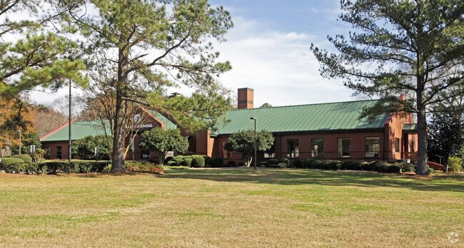
275 Kenyon Rd
153817300
SCL RR, HOBBS, RT.738
Charitableorganization
Suffolk City
X
Virginia
5101560210D
15.87 AC
2025
Suffolk
2025
Hampton Roads
075702
Virginia Beach-Norfolk-Newport News, VA-NC
9,530 SF
DEMOGRAPHICS near 275 Kenyon Rd
1 Mile
3 Mile
5 Mile
2024 Total Population
1,729
7,822
33,305
2029 Population
1,909
8,691
37,250
Pop Growth 2024-2029
+ 10.41%
+ 11.11%
+ 11.85%
Average Age
42
42
40
2024 Total Households
680
3,038
12,830
HH Growth 2024-2029
+ 10.74%
+ 11.45%
+ 12.25%
Median Household Inc
$82,568
$85,170
$65,092
Avg Household Size
2.50
2.60
2.50
2024 Avg HH Vehicles
2.00
2.00
2.00
Median Home Value
$267,229
$287,833
$267,030
Median Year Built
1969
1980
1979
Nearby Places
Map Layers
Map Styles
 Street
 Aerial
- Restaurants
- Banks
- Shops
- Fitness
- Groceries
PUBLIC TRANSPORTATION
AIRPORT
Norfolk International
DRIVE
WALK
Distance
Norfolk International
49 min
32.9 mi
Newport News/Williamsburg International
DRIVE
WALK
Distance
Newport News/Williamsburg International
59 min
39.0 mi
Freight Ports
Virginia Port Authority - Portsmouth
DRIVE
WALK
Distance
Virginia Port Authority - Portsmouth
39 min
25.8 mi
Nearby Properties
Address
Land Use
TOTAL SIZE
Lot Size
Zoning
Address
Land Use
TOTAL SIZE
Lot Size
Zoning
525 SF
161.67 AC
LIGHT INDU
Address
Land Use
TOTAL SIZE
Lot Size
Zoning
336,960 SF
27.70 AC
LIGHT INDU
Address
Land Use
TOTAL SIZE
Lot Size
Zoning
350,550 SF
21 AC
HEAVY INDU
Address
Land Use
TOTAL SIZE
Lot Size
Zoning
1,500 SF
69.49 AC
RES LOW-ME
Address
Land Use
TOTAL SIZE
Lot Size
Zoning
58,439 SF
15.27 AC
RES LOW-ME
Address
Land Use
TOTAL SIZE
Lot Size
Zoning
33,200 SF
41.33 AC
OFFICE-INS
Address
Land Use
TOTAL SIZE
Lot Size
Zoning
86,213 SF
61.69 AC
RES LOW-ME
Address
Land Use
TOTAL SIZE
Lot Size
Zoning
25,000 SF
13.90 AC
LIGHT INDU
Address
Land Use
TOTAL SIZE
Lot Size
Zoning
1,800 SF
905.32 AC
CONSERVATI
Address
Land Use
TOTAL SIZE
Lot Size
Zoning
144 SF
4.75 AC
GENERAL CO
Address
Land Use
TOTAL SIZE
Lot Size
Zoning
49,020 SF
37.44 AC
RESIDENTIA
Address
Land Use
TOTAL SIZE
Lot Size
Zoning
20,520 SF
9.22 AC
GENERAL CO
Address
Land Use
TOTAL SIZE
Lot Size
Zoning
78,405 SF
6.77 AC
HEAVY INDU
The World's #1 Commercial Real Estate Marketplace
Connect with us
© 2025 CoStar Group
The information above has been obtained from sources believed reliable. While we do not doubt its accuracy we have not verified it and make no guarantee, warranty or representation about it. It is your responsibility to independently confirm its accuracy and completeness. Any projections, opinions, assumptions, or estimates used are for example only and do not represent the current or future performance of the property. The value of this transaction to you depends on tax and other factors which should be evaluated by your tax, financial, and legal advisors. You and your advisors should conduct a careful, independent investigation of the property to determine to your satisfaction the suitability of the property for your needs.