Property Record
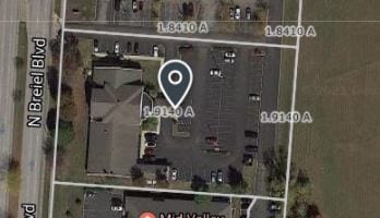
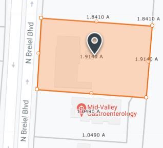
275 N Breiel Blvd, Middletown, OH 45042

NEARBY LISTINGS FOR SALE OR LEASE
Property Detail
275 N Breiel Blvd
Cincinnati, OH-KY-IN
Middletown
Q6531-063-000-008
10697 CTR PT OF W SIDE
Medicalbuilding
Butler
X
Ohio
39165C0015G
10697
2024
1.91 AC
2025
Butler County
012500
Cincinnati/Dayton
18,238 SF
DEMOGRAPHICS near 275 N Breiel Blvd
1 Mile
3 Mile
5 Mile
2024 Total Population
6,989
51,475
91,561
2029 Population
7,071
53,162
95,886
Pop Growth 2024-2029
+ 1.17%
+ 3.28%
+ 4.72%
Average Age
46
40
40
2024 Total Households
2,922
21,581
37,253
HH Growth 2024-2029
+ 1.10%
+ 3.24%
+ 4.68%
Median Household Inc
$79,272
$50,485
$56,180
Avg Household Size
2.30
2.30
2.40
2024 Avg HH Vehicles
2.00
2.00
2.00
Median Home Value
$177,863
$147,346
$157,510
Median Year Built
1965
1965
1967
Nearby Places
Map Layers
Map Styles
 Street
 Aerial
- Restaurants
- Banks
- Shops
- Fitness
- Groceries
PUBLIC TRANSPORTATION
AIRPORT
James M Cox Dayton International
DRIVE
WALK
Distance
James M Cox Dayton International
52 min
37.0 mi
Freight Ports
Port of Toledo
DRIVE
WALK
Distance
Port of Toledo
209 min
177.2 mi
Nearby Properties
Address
Land Use
TOTAL SIZE
Lot Size
Zoning
Address
Land Use
TOTAL SIZE
Lot Size
Zoning
160,701 SF
10.83 AC
Address
Land Use
TOTAL SIZE
Lot Size
Zoning
Address
Land Use
TOTAL SIZE
Lot Size
Zoning
9,224 SF
16.21 AC
Address
Land Use
TOTAL SIZE
Lot Size
Zoning
5,000 SF
60.29 AC
Address
Land Use
TOTAL SIZE
Lot Size
Zoning
7.19 AC
Address
Land Use
TOTAL SIZE
Lot Size
Zoning
9,224 SF
16.21 AC
Address
Land Use
TOTAL SIZE
Lot Size
Zoning
7.18 AC
Address
Land Use
TOTAL SIZE
Lot Size
Zoning
27,780 SF
1.20 AC
Address
Land Use
TOTAL SIZE
Lot Size
Zoning
24,808 SF
3.26 AC
Address
Land Use
TOTAL SIZE
Lot Size
Zoning
2,221 SF
7.84 AC
Address
Land Use
TOTAL SIZE
Lot Size
Zoning
16.57 AC
Address
Land Use
TOTAL SIZE
Lot Size
Zoning
Address
Land Use
TOTAL SIZE
Lot Size
Zoning
15,228 SF
37.19 AC
R1
Address
Land Use
TOTAL SIZE
Lot Size
Zoning
120,685 SF
21.52 AC
Address
Land Use
TOTAL SIZE
Lot Size
Zoning
14,325 SF
1.84 AC
Address
Land Use
TOTAL SIZE
Lot Size
Zoning
37,842 SF
13.68 AC
Address
Land Use
TOTAL SIZE
Lot Size
Zoning
17.24 AC
ADV
Address
Land Use
TOTAL SIZE
Lot Size
Zoning
93,289 SF
11.43 AC
Address
Land Use
TOTAL SIZE
Lot Size
Zoning
84,352 SF
0.30 AC
Address
Land Use
TOTAL SIZE
Lot Size
Zoning
86.47 AC
ADV
Address
Land Use
TOTAL SIZE
Lot Size
Zoning
190,295 SF
21.70 AC
Address
Land Use
TOTAL SIZE
Lot Size
Zoning
54,005 SF
0.33 AC
Address
Land Use
TOTAL SIZE
Lot Size
Zoning
20,250 SF
3.28 AC
Address
Land Use
TOTAL SIZE
Lot Size
Zoning
109,584 SF
9.77 AC
Address
Land Use
TOTAL SIZE
Lot Size
Zoning
113,241 SF
7.84 AC
Address
Land Use
TOTAL SIZE
Lot Size
Zoning
12,500 SF
32.38 AC
MXUC
Address
Land Use
TOTAL SIZE
Lot Size
Zoning
33,362 SF
0.73 AC
Address
Land Use
TOTAL SIZE
Lot Size
Zoning
868 SF
36.06 AC
Address
Land Use
TOTAL SIZE
Lot Size
Zoning
111,304 SF
19.53 AC
Address
Land Use
TOTAL SIZE
Lot Size
Zoning
371,743 SF
24.58 AC
ADV
The World's #1 Commercial Real Estate Marketplace
Connect with us
© 2026 CoStar Group
The information above has been obtained from sources believed reliable. While we do not doubt its accuracy we have not verified it and make no guarantee, warranty or representation about it. It is your responsibility to independently confirm its accuracy and completeness. Any projections, opinions, assumptions, or estimates used are for example only and do not represent the current or future performance of the property. The value of this transaction to you depends on tax and other factors which should be evaluated by your tax, financial, and legal advisors. You and your advisors should conduct a careful, independent investigation of the property to determine to your satisfaction the suitability of the property for your needs.