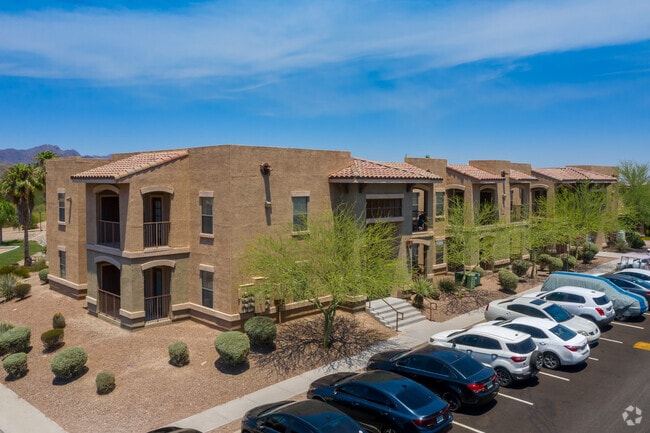
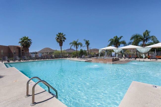
Property Record
275 N Greasewood Rd, Tucson, AZ 85745
NEARBY LISTINGS FOR SALE OR LEASE
Property Detail
275 N Greasewood Rd
Tucson, AZ
Tucson Park West Blk 1
116-11-001P
TUCSON PARK WEST N105 BLK 1 EXC E820
Apartment
Pima
X
Arizona
04019C2260L
67
2025
20.45 AC
2025
Ward 1
0044112003
Tucson
248,388 SF
DEMOGRAPHICS near 275 N Greasewood Rd
1 Mile
3 Mile
5 Mile
2024 Total Population
7,402
50,271
176,169
2029 Population
8,051
53,397
185,792
Pop Growth 2024-2029
+ 8.77%
+ 6.22%
+ 5.46%
Average Age
37
39
38
2024 Total Households
3,449
21,725
74,322
HH Growth 2024-2029
+ 9.05%
+ 6.44%
+ 5.70%
Median Household Inc
$64,716
$59,717
$48,615
Avg Household Size
2.10
2.20
2.20
2024 Avg HH Vehicles
2.00
2.00
2.00
Median Home Value
$325,813
$312,987
$262,553
Median Year Built
1994
1984
1979
Nearby Places
Map Layers
Map Styles
 Street
 Aerial
- Restaurants
- Banks
- Shops
- Fitness
- Groceries
PUBLIC TRANSPORTATION
COMMUTER RAIL
Tucson Amtrak Station (Sunset Limited - Amtrak, Texas Eagle - Amtrak)
DRIVE
WALK
Distance
Tucson Amtrak Station (Sunset Limited - Amtrak, Texas Eagle - Amtrak)
8 min
3.7 mi
AIRPORT
Tucson International
DRIVE
WALK
Distance
Tucson International
22 min
11.5 mi
Freight Ports
Port of San Diego
DRIVE
WALK
Distance
Port of San Diego
437 min
409.9 mi
Nearby Properties
Address
Land Use
TOTAL SIZE
Lot Size
Zoning
Address
Land Use
TOTAL SIZE
Lot Size
Zoning
134,710 SF
9.59 AC
I1
Address
Land Use
TOTAL SIZE
Lot Size
Zoning
813,186 SF
3.65 AC
OCR2
Address
Land Use
TOTAL SIZE
Lot Size
Zoning
819,879 SF
44.77 AC
SP
Address
Land Use
TOTAL SIZE
Lot Size
Zoning
655,604 SF
233.08 AC
RX2
Address
Land Use
TOTAL SIZE
Lot Size
Zoning
868,743 SF
17.17 AC
O3
Address
Land Use
TOTAL SIZE
Lot Size
Zoning
380,470 SF
17.48 AC
R1
Address
Land Use
TOTAL SIZE
Lot Size
Zoning
239,060 SF
7.85 AC
Address
Land Use
TOTAL SIZE
Lot Size
Zoning
52,531 SF
11.37 AC
SR
Address
Land Use
TOTAL SIZE
Lot Size
Zoning
198,830 SF
2.22 AC
Address
Land Use
TOTAL SIZE
Lot Size
Zoning
119,759 SF
3.49 AC
C3
Address
Land Use
TOTAL SIZE
Lot Size
Zoning
36,100 SF
2.42 AC
I1
Address
Land Use
TOTAL SIZE
Lot Size
Zoning
229,162 SF
35 AC
R1
Address
Land Use
TOTAL SIZE
Lot Size
Zoning
291,038 SF
16.42 AC
C1
Address
Land Use
TOTAL SIZE
Lot Size
Zoning
214,907 SF
12.03 AC
C1
Address
Land Use
TOTAL SIZE
Lot Size
Zoning
147,258 SF
6.43 AC
Address
Land Use
TOTAL SIZE
Lot Size
Zoning
79,546 SF
6.54 AC
Address
Land Use
TOTAL SIZE
Lot Size
Zoning
74,952 SF
5.01 AC
PAD4
Address
Land Use
TOTAL SIZE
Lot Size
Zoning
176,857 SF
14.20 AC
R2
Address
Land Use
TOTAL SIZE
Lot Size
Zoning
502,857 SF
2.63 AC
I1
Address
Land Use
TOTAL SIZE
Lot Size
Zoning
160,456 SF
11.35 AC
Address
Land Use
TOTAL SIZE
Lot Size
Zoning
10.60 AC
Address
Land Use
TOTAL SIZE
Lot Size
Zoning
55,016 SF
3.63 AC
O3
Address
Land Use
TOTAL SIZE
Lot Size
Zoning
230,676 SF
14.99 AC
Address
Land Use
TOTAL SIZE
Lot Size
Zoning
7,079 SF
3.79 AC
C1
Address
Land Use
TOTAL SIZE
Lot Size
Zoning
208,342 SF
1.05 AC
PAD10
Address
Land Use
TOTAL SIZE
Lot Size
Zoning
119,868 SF
1.71 AC
O3
Address
Land Use
TOTAL SIZE
Lot Size
Zoning
87,075 SF
1.76 AC
O3
Address
Land Use
TOTAL SIZE
Lot Size
Zoning
2.37 AC
OCR2
Address
Land Use
TOTAL SIZE
Lot Size
Zoning
138,160 SF
1.61 AC
The World's #1 Commercial Real Estate Marketplace
Connect with us
© 2025 CoStar Group
The information above has been obtained from sources believed reliable. While we do not doubt its accuracy we have not verified it and make no guarantee, warranty or representation about it. It is your responsibility to independently confirm its accuracy and completeness. Any projections, opinions, assumptions, or estimates used are for example only and do not represent the current or future performance of the property. The value of this transaction to you depends on tax and other factors which should be evaluated by your tax, financial, and legal advisors. You and your advisors should conduct a careful, independent investigation of the property to determine to your satisfaction the suitability of the property for your needs.