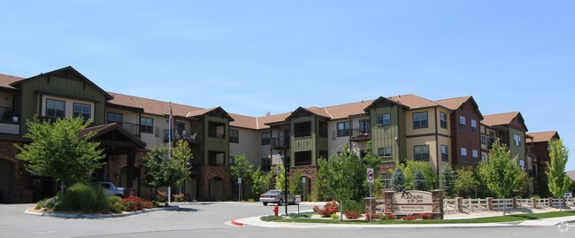
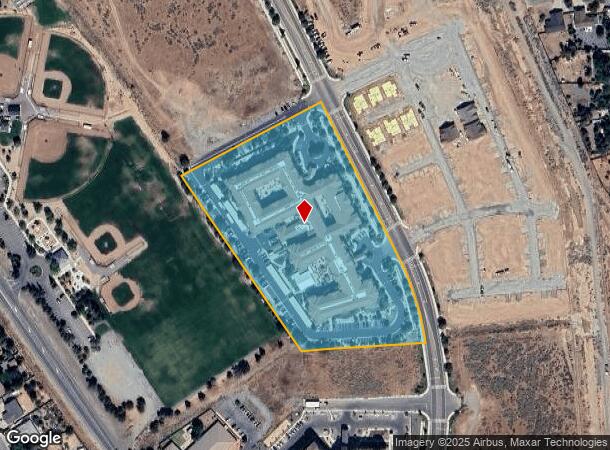
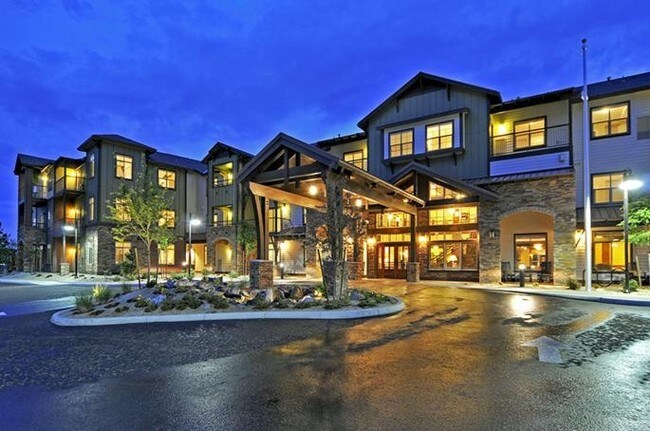
Property Record
275 Neighborhood Way, Sparks, NV 89441
NEARBY LISTINGS FOR SALE OR LEASE
-
-
View all Sparks listings for sale on LoopNet.com
Property Detail
275 Neighborhood Way
Reno, NV
_Unspecified
532-031-12
PM 4799 LT B
Commercialnec
Washoe
X
Nevada
32031C2865G
b
2025
7 AC
2026
N Outlying Washoe County
003518
Reno/Sparks
238,764 SF
DEMOGRAPHICS near 275 Neighborhood Way
1 Mile
3 Mile
5 Mile
2024 Total Population
6,693
31,925
74,170
2029 Population
7,072
34,063
78,303
Pop Growth 2024-2029
+ 5.66%
+ 6.70%
+ 5.57%
Average Age
43
41
40
2024 Total Households
2,555
11,607
26,066
HH Growth 2024-2029
+ 5.79%
+ 6.79%
+ 5.72%
Median Household Inc
$94,618
$109,324
$101,459
Avg Household Size
2.60
2.70
2.80
2024 Avg HH Vehicles
2.00
2.00
2.00
Median Home Value
$420,094
$471,014
$451,787
Median Year Built
1996
2004
2001
Nearby Places
Map Layers
Map Styles
 Street
 Aerial
- Restaurants
- Banks
- Shops
- Fitness
- Groceries
PUBLIC TRANSPORTATION
AIRPORT
Reno/Tahoe International
DRIVE
WALK
Distance
Reno/Tahoe International
38 min
15.8 mi
Freight Ports
Port of Stockton
DRIVE
WALK
Distance
Port of Stockton
223 min
190.2 mi
Nearby Properties
Address
Land Use
TOTAL SIZE
Lot Size
Zoning
Address
Land Use
TOTAL SIZE
Lot Size
Zoning
416,482 SF
21.84 AC
PD
Address
Land Use
TOTAL SIZE
Lot Size
Zoning
333,867 SF
14.71 AC
NUD
Address
Land Use
TOTAL SIZE
Lot Size
Zoning
271,111 SF
31.84 AC
NUD
Address
Land Use
TOTAL SIZE
Lot Size
Zoning
349,926 SF
76.09 AC
I
Address
Land Use
TOTAL SIZE
Lot Size
Zoning
602,186 SF
66 AC
I
Address
Land Use
TOTAL SIZE
Lot Size
Zoning
308,431 SF
20 AC
PD
Address
Land Use
TOTAL SIZE
Lot Size
Zoning
236,695 SF
8.66 AC
PD
Address
Land Use
TOTAL SIZE
Lot Size
Zoning
289,637 SF
53.48 AC
PSP
Address
Land Use
TOTAL SIZE
Lot Size
Zoning
231,353 SF
11.52 AC
NUD
Address
Land Use
TOTAL SIZE
Lot Size
Zoning
188,281 SF
641.92 AC
OS 88% / G
Address
Land Use
TOTAL SIZE
Lot Size
Zoning
209,527 SF
5.28 AC
NC
Address
Land Use
TOTAL SIZE
Lot Size
Zoning
160,562 SF
17.10 AC
I
Address
Land Use
TOTAL SIZE
Lot Size
Zoning
464,360 SF
36.05 AC
I
Address
Land Use
TOTAL SIZE
Lot Size
Zoning
181,857 SF
8.19 AC
NUD
Address
Land Use
TOTAL SIZE
Lot Size
Zoning
419,040 SF
20.67 AC
I
Address
Land Use
TOTAL SIZE
Lot Size
Zoning
408,965 SF
20.44 AC
I
Address
Land Use
TOTAL SIZE
Lot Size
Zoning
412,614 SF
25.93 AC
I
Address
Land Use
TOTAL SIZE
Lot Size
Zoning
188,646 SF
20 AC
I
Address
Land Use
TOTAL SIZE
Lot Size
Zoning
411,100 SF
19.44 AC
I
Address
Land Use
TOTAL SIZE
Lot Size
Zoning
197,364 SF
11.34 AC
NUD
Address
Land Use
TOTAL SIZE
Lot Size
Zoning
186,572 SF
12.17 AC
NUD
Address
Land Use
TOTAL SIZE
Lot Size
Zoning
408,660 SF
20.15 AC
I
Address
Land Use
TOTAL SIZE
Lot Size
Zoning
74,637 SF
6.04 AC
NUD
Address
Land Use
TOTAL SIZE
Lot Size
Zoning
195,000 SF
11.18 AC
I
Address
Land Use
TOTAL SIZE
Lot Size
Zoning
185,000 SF
10 AC
I
Address
Land Use
TOTAL SIZE
Lot Size
Zoning
146,900 SF
10 AC
I
Address
Land Use
TOTAL SIZE
Lot Size
Zoning
55,704 SF
14.03 AC
MDS 1% / O
Address
Land Use
TOTAL SIZE
Lot Size
Zoning
122,223 SF
20 AC
PSP
Address
Land Use
TOTAL SIZE
Lot Size
Zoning
152,640 SF
24.48 AC
I
The World's #1 Commercial Real Estate Marketplace
Connect with us
© 2026 CoStar Group
The information above has been obtained from sources believed reliable. While we do not doubt its accuracy we have not verified it and make no guarantee, warranty or representation about it. It is your responsibility to independently confirm its accuracy and completeness. Any projections, opinions, assumptions, or estimates used are for example only and do not represent the current or future performance of the property. The value of this transaction to you depends on tax and other factors which should be evaluated by your tax, financial, and legal advisors. You and your advisors should conduct a careful, independent investigation of the property to determine to your satisfaction the suitability of the property for your needs.