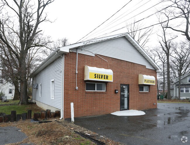
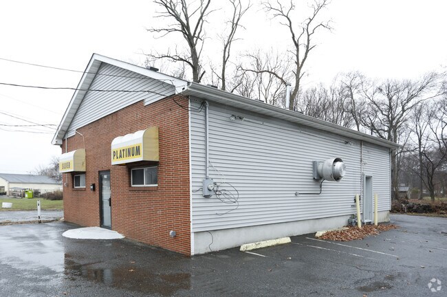
Property Record
275 State Route 36, Hazlet, NJ 07730

NEARBY LISTINGS FOR SALE OR LEASE
Property Detail
275 State Route 36
18-00032-0000-00012
ADDITIONAL LOTS: DORENS DELI
Commercialnec
Monmouth
X
New Jersey
34025C0034F
12
2024
0.13 AC
2025
Eastern Monmouth
802200
Northern New Jersey
1,200 SF
Lakewood-New Brunswick, NJ
DEMOGRAPHICS near 275 State Route 36
1 Mile
3 Mile
5 Mile
2024 Total Population
11,055
62,281
112,499
2029 Population
10,967
61,894
111,676
Pop Growth 2024-2029
(0.80%)
(0.62%)
(0.73%)
Average Age
41
42
42
2024 Total Households
4,181
22,713
41,173
HH Growth 2024-2029
(1.08%)
(0.84%)
(0.90%)
Median Household Inc
$83,023
$98,469
$108,663
Avg Household Size
2.50
2.70
2.60
2024 Avg HH Vehicles
2.00
2.00
2.00
Median Home Value
$284,027
$397,095
$421,130
Median Year Built
1961
1966
1966
Nearby Places
Map Layers
Map Styles
 Street
 Aerial
- Restaurants
- Banks
- Shops
- Fitness
- Groceries
PUBLIC TRANSPORTATION
COMMUTER RAIL
Hazlet (North Jersey Coast Line - NJ Transit Commuter Rail (NJ Transit))
DRIVE
WALK
Distance
Hazlet (North Jersey Coast Line - NJ Transit Commuter Rail (NJ Transit))
11 min
4.2 mi
Middletown New Jersey (North Jersey Coast Line - NJ Transit Commuter Rail (NJ Transit))
DRIVE
WALK
Distance
Middletown New Jersey (North Jersey Coast Line - NJ Transit Commuter Rail (NJ Transit))
12 min
4.4 mi
AIRPORT
Newark Liberty International
DRIVE
WALK
Distance
Newark Liberty International
38 min
32.4 mi
Freight Ports
New York Container Terminal
DRIVE
WALK
Distance
New York Container Terminal
1 min
13.7 mi
SALE & LEASE HISTORY
LISTING DATE
SALE/LEASE

Sep 24, 2016
For Sale
Nearby Properties
Address
Land Use
TOTAL SIZE
Lot Size
Zoning
Address
Land Use
TOTAL SIZE
Lot Size
Zoning
836,881 SF
253 AC
R-45
Address
Land Use
TOTAL SIZE
Lot Size
Zoning
2.91 AC
Address
Land Use
TOTAL SIZE
Lot Size
Zoning
6,500 SF
48.71 AC
CI
Address
Land Use
TOTAL SIZE
Lot Size
Zoning
37.83 AC
PUD
Address
Land Use
TOTAL SIZE
Lot Size
Zoning
10.44 AC
TMHO
Address
Land Use
TOTAL SIZE
Lot Size
Zoning
158,298 SF
20.01 AC
MU15
Address
Land Use
TOTAL SIZE
Lot Size
Zoning
29.59 AC
CI
Address
Land Use
TOTAL SIZE
Lot Size
Zoning
118,375 SF
18.20 AC
MU15
Address
Land Use
TOTAL SIZE
Lot Size
Zoning
151,463 SF
20.58 AC
M-2
Address
Land Use
TOTAL SIZE
Lot Size
Zoning
39,965 SF
17.14 AC
BH
Address
Land Use
TOTAL SIZE
Lot Size
Zoning
186,567 SF
2.31 AC
RC
Address
Land Use
TOTAL SIZE
Lot Size
Zoning
82,166 SF
25.10 AC
R-7
Address
Land Use
TOTAL SIZE
Lot Size
Zoning
3,641 SF
22.58 AC
C1
Address
Land Use
TOTAL SIZE
Lot Size
Zoning
196,948 SF
19.80 AC
BH
Address
Land Use
TOTAL SIZE
Lot Size
Zoning
42,314 SF
52 AC
IA
Address
Land Use
TOTAL SIZE
Lot Size
Zoning
127,410 SF
0.01 AC
RHA
Address
Land Use
TOTAL SIZE
Lot Size
Zoning
8.62 AC
RC
Address
Land Use
TOTAL SIZE
Lot Size
Zoning
6 AC
RC
Address
Land Use
TOTAL SIZE
Lot Size
Zoning
83,416 SF
44.01 AC
R-22
Address
Land Use
TOTAL SIZE
Lot Size
Zoning
5 AC
PUD
Address
Land Use
TOTAL SIZE
Lot Size
Zoning
141,313 SF
23.19 AC
R-22
Address
Land Use
TOTAL SIZE
Lot Size
Zoning
4,005 SF
87 SF
B-2
Address
Land Use
TOTAL SIZE
Lot Size
Zoning
9,904 SF
135.45 AC
M-2
Address
Land Use
TOTAL SIZE
Lot Size
Zoning
67,832 SF
10.46 AC
RGA2
Address
Land Use
TOTAL SIZE
Lot Size
Zoning
41,140 SF
3.15 AC
R-7
Address
Land Use
TOTAL SIZE
Lot Size
Zoning
28 AC
RO3
Address
Land Use
TOTAL SIZE
Lot Size
Zoning
4,078 SF
15.14 AC
SC2
Address
Land Use
TOTAL SIZE
Lot Size
Zoning
124,651 SF
25.02 AC
CD
Address
Land Use
TOTAL SIZE
Lot Size
Zoning
142,360 SF
16.50 AC
BH
Address
Land Use
TOTAL SIZE
Lot Size
Zoning
200,514 SF
37.60 AC
R100
The World's #1 Commercial Real Estate Marketplace
Connect with us
© 2026 CoStar Group
The information above has been obtained from sources believed reliable. While we do not doubt its accuracy we have not verified it and make no guarantee, warranty or representation about it. It is your responsibility to independently confirm its accuracy and completeness. Any projections, opinions, assumptions, or estimates used are for example only and do not represent the current or future performance of the property. The value of this transaction to you depends on tax and other factors which should be evaluated by your tax, financial, and legal advisors. You and your advisors should conduct a careful, independent investigation of the property to determine to your satisfaction the suitability of the property for your needs.