Property Record
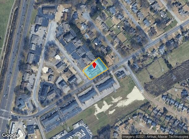
275 S Walnut Bend Rd, Cordova, TN 38018
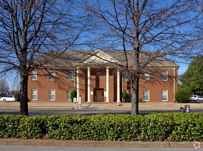

This Property Is For Sale
NEARBY LISTINGS FOR SALE OR LEASE
Property Detail
275 S Walnut Bend Rd
Memphis, TN-MS-AR
Germatown Pkwy Commons Ph Ii Par 2
09-1113-0-0018
NS GERMAN OAK DR COR WALNUT BEND RD NW MAP: 143M
Officebuilding
Shelby
X
Tennessee
47157C0456G
17
2024
0.69 AC
2025
Northeast
021140
Memphis
10,860 SF
DEMOGRAPHICS near 275 S Walnut Bend Rd
1 Mile
3 Mile
5 Mile
2024 Total Population
4,617
54,903
149,323
2029 Population
4,563
53,529
145,466
Pop Growth 2024-2029
(1.17%)
(2.50%)
(2.58%)
Average Age
39
41
40
2024 Total Households
2,033
22,821
60,681
HH Growth 2024-2029
(1.08%)
(2.51%)
(2.62%)
Median Household Inc
$75,498
$95,600
$89,977
Avg Household Size
2.30
2.40
2.40
2024 Avg HH Vehicles
2.00
2.00
2.00
Median Home Value
$242,742
$291,948
$301,256
Median Year Built
1988
1988
1988
Nearby Places
Map Layers
Map Styles
 Street
 Aerial
- Restaurants
- Banks
- Shops
- Fitness
- Groceries
PUBLIC TRANSPORTATION
AIRPORT
Memphis International
DRIVE
WALK
Distance
Memphis International
32 min
16.9 mi
Nearby Properties
Address
Land Use
TOTAL SIZE
Lot Size
Zoning
Address
Land Use
TOTAL SIZE
Lot Size
Zoning
92,452 SF
5 AC
O
Address
Land Use
TOTAL SIZE
Lot Size
Zoning
169,769 SF
3.13 AC
OG-1
Address
Land Use
TOTAL SIZE
Lot Size
Zoning
399,358 SF
4.69 AC
C-2
Address
Land Use
TOTAL SIZE
Lot Size
Zoning
175,984 SF
22.75 AC
RU-4
Address
Land Use
TOTAL SIZE
Lot Size
Zoning
30.93 AC
R
Address
Land Use
TOTAL SIZE
Lot Size
Zoning
1,919.25 AC
CA
Address
Land Use
TOTAL SIZE
Lot Size
Zoning
57,751 SF
7.36 AC
O
Address
Land Use
TOTAL SIZE
Lot Size
Zoning
204,904 SF
6.87 AC
PD
Address
Land Use
TOTAL SIZE
Lot Size
Zoning
196,088 SF
5.28 AC
C-2
Address
Land Use
TOTAL SIZE
Lot Size
Zoning
358,137 SF
32.19 AC
RU-3
Address
Land Use
TOTAL SIZE
Lot Size
Zoning
159,917 SF
9.61 AC
O-51
Address
Land Use
TOTAL SIZE
Lot Size
Zoning
298,374 SF
12.57 AC
SC-1
Address
Land Use
TOTAL SIZE
Lot Size
Zoning
50,534 SF
4.32 AC
O
Address
Land Use
TOTAL SIZE
Lot Size
Zoning
375,848 SF
27.49 AC
R-H
Address
Land Use
TOTAL SIZE
Lot Size
Zoning
31,562 SF
27.68 AC
R-T
Address
Land Use
TOTAL SIZE
Lot Size
Zoning
83,821 SF
39.50 AC
RU-3
Address
Land Use
TOTAL SIZE
Lot Size
Zoning
91,664 SF
9.57 AC
SC-1
Address
Land Use
TOTAL SIZE
Lot Size
Zoning
172,795 SF
10.95 AC
C-2
Address
Land Use
TOTAL SIZE
Lot Size
Zoning
91,232 SF
21.66 AC
IH
Address
Land Use
TOTAL SIZE
Lot Size
Zoning
35,313 SF
22.81 AC
RU-3
Address
Land Use
TOTAL SIZE
Lot Size
Zoning
54,560 SF
17.29 AC
RU-2
Address
Land Use
TOTAL SIZE
Lot Size
Zoning
80,403 SF
9.85 AC
SC-1
Address
Land Use
TOTAL SIZE
Lot Size
Zoning
64,807 SF
6.08 AC
C-2
Address
Land Use
TOTAL SIZE
Lot Size
Zoning
50,218 SF
30.77 AC
R-T
Address
Land Use
TOTAL SIZE
Lot Size
Zoning
43.88 AC
R-10
Address
Land Use
TOTAL SIZE
Lot Size
Zoning
234,360 SF
22.12 AC
IH
Address
Land Use
TOTAL SIZE
Lot Size
Zoning
85,599 SF
2.40 AC
C-2
Address
Land Use
TOTAL SIZE
Lot Size
Zoning
59,675 SF
27.21 AC
R-T
Address
Land Use
TOTAL SIZE
Lot Size
Zoning
60,724 SF
6.13 AC
SC-1
Address
Land Use
TOTAL SIZE
Lot Size
Zoning
76,991 SF
5.30 AC
SC-1
The World's #1 Commercial Real Estate Marketplace
Connect with us
© 2026 CoStar Group
The information above has been obtained from sources believed reliable. While we do not doubt its accuracy we have not verified it and make no guarantee, warranty or representation about it. It is your responsibility to independently confirm its accuracy and completeness. Any projections, opinions, assumptions, or estimates used are for example only and do not represent the current or future performance of the property. The value of this transaction to you depends on tax and other factors which should be evaluated by your tax, financial, and legal advisors. You and your advisors should conduct a careful, independent investigation of the property to determine to your satisfaction the suitability of the property for your needs.