Property Record
275 Willard Way, Collierville, TN 38017


NEARBY LISTINGS FOR SALE OR LEASE
Property Detail
275 Willard Way
Memphis, TN-MS-AR
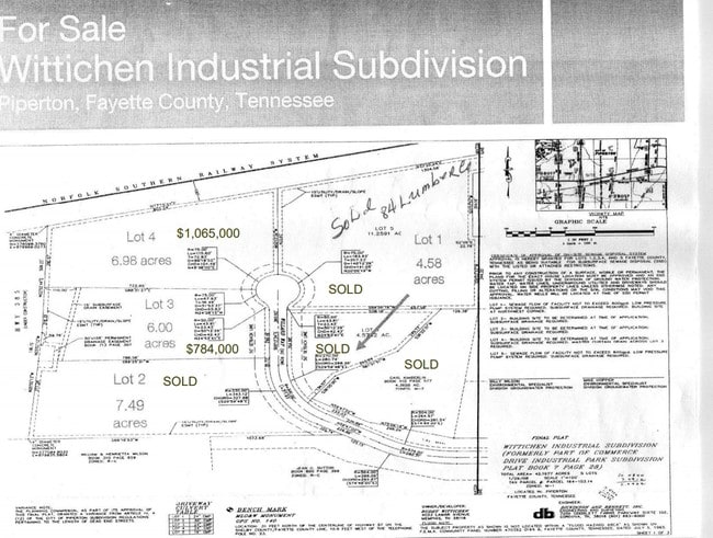
Wittichen Industrial Subd
164-103.17
WITTICHEN INDUSTRIAL SUBD PB: 11 PG: 163 LOT: 2 REVISED PLAT
Industrialgeneral
Fayette
X
Tennessee
47157C0495G
2
2024
10.02 AC
2025
Fayette County
021611
Memphis
125,846 SF
DEMOGRAPHICS near 275 Willard Way
1 Mile
3 Mile
5 Mile
2024 Total Population
685
17,775
44,925
2029 Population
697
17,657
44,403
Pop Growth 2024-2029
+ 1.75%
(0.66%)
(1.16%)
Average Age
43
41
40
2024 Total Households
248
6,301
15,987
HH Growth 2024-2029
+ 2.02%
(0.59%)
(1.18%)
Median Household Inc
$110,555
$110,641
$120,333
Avg Household Size
2.70
2.80
2.80
2024 Avg HH Vehicles
2.00
2.00
2.00
Median Home Value
$338,947
$339,238
$375,911
Median Year Built
1994
1988
1995
Nearby Places
Map Layers
Map Styles
 Street
 Aerial
- Restaurants
- Banks
- Shops
- Fitness
- Groceries
PUBLIC TRANSPORTATION
AIRPORT
Memphis International
DRIVE
WALK
Distance
Memphis International
41 min
23.6 mi
SALE & LEASE HISTORY
LISTING DATE
SALE/LEASE

Jul 11, 2018
For Sale
Nearby Properties
Address
Land Use
TOTAL SIZE
Lot Size
Zoning
Address
Land Use
TOTAL SIZE
Lot Size
Zoning
241,626 SF
19.59 AC
Address
Land Use
TOTAL SIZE
Lot Size
Zoning
98,107 SF
10.09 AC
RI
Address
Land Use
TOTAL SIZE
Lot Size
Zoning
963,300 SF
52.78 AC
B3
Address
Land Use
TOTAL SIZE
Lot Size
Zoning
397,593 SF
61.46 AC
R-1
Address
Land Use
TOTAL SIZE
Lot Size
Zoning
256,456 SF
51.05 AC
M2
Address
Land Use
TOTAL SIZE
Lot Size
Zoning
197,121 SF
22.07 AC
SCC
Address
Land Use
TOTAL SIZE
Lot Size
Zoning
36,800 SF
18.50 AC
Address
Land Use
TOTAL SIZE
Lot Size
Zoning
155.29 AC
CA
Address
Land Use
TOTAL SIZE
Lot Size
Zoning
111,730 SF
11.30 AC
RI
Address
Land Use
TOTAL SIZE
Lot Size
Zoning
49,377 SF
17.50 AC
Address
Land Use
TOTAL SIZE
Lot Size
Zoning
125,993 SF
9.08 AC
RI
Address
Land Use
TOTAL SIZE
Lot Size
Zoning
160,180 SF
12.88 AC
GI
Address
Land Use
TOTAL SIZE
Lot Size
Zoning
180,755 SF
15.39 AC
SCC
Address
Land Use
TOTAL SIZE
Lot Size
Zoning
46,628 SF
10.62 AC
GI
Address
Land Use
TOTAL SIZE
Lot Size
Zoning
130,000 SF
11.98 AC
RI
Address
Land Use
TOTAL SIZE
Lot Size
Zoning
68.10 AC
R-2
Address
Land Use
TOTAL SIZE
Lot Size
Zoning
27,642 SF
5.38 AC
Address
Land Use
TOTAL SIZE
Lot Size
Zoning
31,956 SF
10.64 AC
Address
Land Use
TOTAL SIZE
Lot Size
Zoning
525,656 SF
14.10 AC
RI
Address
Land Use
TOTAL SIZE
Lot Size
Zoning
22,272 SF
3.26 AC
RI
Address
Land Use
TOTAL SIZE
Lot Size
Zoning
38,981 SF
2.70 AC
GC
Address
Land Use
TOTAL SIZE
Lot Size
Zoning
5.62 AC
R-1
Address
Land Use
TOTAL SIZE
Lot Size
Zoning
86,918 SF
4.98 AC
GI
Address
Land Use
TOTAL SIZE
Lot Size
Zoning
1,305 SF
30.30 AC
AG
Address
Land Use
TOTAL SIZE
Lot Size
Zoning
3.46 AC
R-1
Address
Land Use
TOTAL SIZE
Lot Size
Zoning
11,967 SF
3.48 AC
GI
Address
Land Use
TOTAL SIZE
Lot Size
Zoning
80,000 SF
6.66 AC
Address
Land Use
TOTAL SIZE
Lot Size
Zoning
62,170 SF
4.01 AC
GI
Address
Land Use
TOTAL SIZE
Lot Size
Zoning
16,038 SF
2.61 AC
GC
The World's #1 Commercial Real Estate Marketplace
Connect with us
© 2026 CoStar Group
The information above has been obtained from sources believed reliable. While we do not doubt its accuracy we have not verified it and make no guarantee, warranty or representation about it. It is your responsibility to independently confirm its accuracy and completeness. Any projections, opinions, assumptions, or estimates used are for example only and do not represent the current or future performance of the property. The value of this transaction to you depends on tax and other factors which should be evaluated by your tax, financial, and legal advisors. You and your advisors should conduct a careful, independent investigation of the property to determine to your satisfaction the suitability of the property for your needs.