Property Record
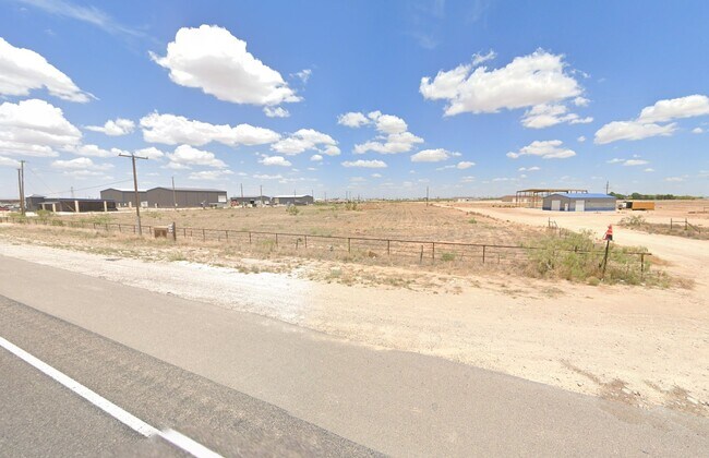
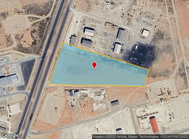
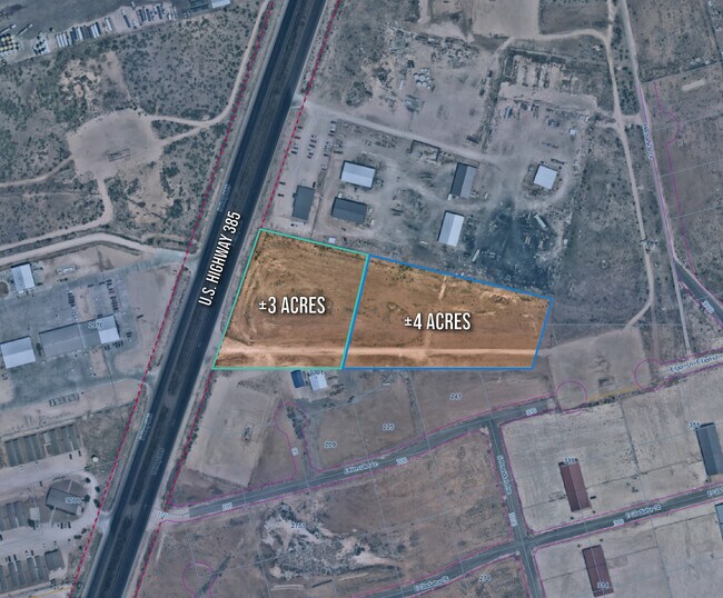
S Highway 385, Odessa, TX 79766

NEARBY LISTINGS FOR SALE OR LEASE
Property Detail
S Highway 385
425000023503000
T-2-S BLK 42 SEC 45 (CARD #3C) OUTSIDE CITY LIMITS
Vacantlandnec
Ector
X
Texas
48135C0365E
7.82 AC
2025
Midland & Odessa
2025
Other Market Areas
002200
Odessa, TX
DEMOGRAPHICS near S Highway 385
1 Mile
3 Mile
5 Mile
2024 Total Population
606
13,299
51,370
2029 Population
597
13,027
50,390
Pop Growth 2024-2029
(1.49%)
(2.05%)
(1.91%)
Average Age
34
35
35
2024 Total Households
149
4,292
17,394
HH Growth 2024-2029
(2.01%)
(2.54%)
(2.29%)
Median Household Inc
$62,187
$44,937
$48,469
Avg Household Size
3.20
2.90
2.80
2024 Avg HH Vehicles
2.00
2.00
2.00
Median Home Value
$320,689
$85,367
$115,727
Median Year Built
2000
1981
1970
Nearby Places
Map Layers
Map Styles
 Street
 Aerial
- Restaurants
- Banks
- Shops
- Fitness
- Groceries
PUBLIC TRANSPORTATION
AIRPORT
Midland International Air And Space Port
DRIVE
WALK
Distance
Midland International Air And Space Port
21 min
15.0 mi
Freight Ports
Port of Corpus Christi
DRIVE
WALK
Distance
Port of Corpus Christi
498 min
481.6 mi
SALE & LEASE HISTORY
LISTING DATE
SALE/LEASE

Jun 07, 2023
For Sale
Nearby Properties
Address
Land Use
TOTAL SIZE
Lot Size
Zoning
Address
Land Use
TOTAL SIZE
Lot Size
Zoning
232,969 SF
19.81 AC
EB7
Address
Land Use
TOTAL SIZE
Lot Size
Zoning
10,644 SF
57.53 AC
Address
Land Use
TOTAL SIZE
Lot Size
Zoning
36,648 SF
86.41 AC
ES1
Address
Land Use
TOTAL SIZE
Lot Size
Zoning
11,600 SF
28.47 AC
ES1
Address
Land Use
TOTAL SIZE
Lot Size
Zoning
112,000 SF
19.10 AC
ES2
Address
Land Use
TOTAL SIZE
Lot Size
Zoning
72,624 SF
2.28 AC
ES1
Address
Land Use
TOTAL SIZE
Lot Size
Zoning
153,754 SF
9.57 AC
EE5
Address
Land Use
TOTAL SIZE
Lot Size
Zoning
5,826 SF
32.11 AC
ES1
Address
Land Use
TOTAL SIZE
Lot Size
Zoning
61,570 SF
6.44 AC
ES1
Address
Land Use
TOTAL SIZE
Lot Size
Zoning
138,064 SF
8.50 AC
EE5
Address
Land Use
TOTAL SIZE
Lot Size
Zoning
27,350 SF
30.13 AC
EB7
Address
Land Use
TOTAL SIZE
Lot Size
Zoning
3,141 SF
2.92 AC
EB7
Address
Land Use
TOTAL SIZE
Lot Size
Zoning
15,200 SF
29.64 AC
ES1
Address
Land Use
TOTAL SIZE
Lot Size
Zoning
9,754 SF
14.89 AC
ES1
Address
Land Use
TOTAL SIZE
Lot Size
Zoning
47,000 SF
17.51 AC
EB7
Address
Land Use
TOTAL SIZE
Lot Size
Zoning
50,816 SF
10.73 AC
EB7
Address
Land Use
TOTAL SIZE
Lot Size
Zoning
2,592 SF
61.28 AC
ES1
Address
Land Use
TOTAL SIZE
Lot Size
Zoning
10,728 SF
Address
Land Use
TOTAL SIZE
Lot Size
Zoning
32,622 SF
2.55 AC
EB7
Address
Land Use
TOTAL SIZE
Lot Size
Zoning
75,000 SF
61.98 AC
ES1
Address
Land Use
TOTAL SIZE
Lot Size
Zoning
77,326 SF
1.96 AC
EB7
Address
Land Use
TOTAL SIZE
Lot Size
Zoning
2,000 SF
4.56 AC
EB7
Address
Land Use
TOTAL SIZE
Lot Size
Zoning
24,220 SF
29.95 AC
ES2
Address
Land Use
TOTAL SIZE
Lot Size
Zoning
48,784 SF
12.86 AC
EE5
Address
Land Use
TOTAL SIZE
Lot Size
Zoning
3,586 SF
2.27 AC
ES2
Address
Land Use
TOTAL SIZE
Lot Size
Zoning
10,300 SF
10.92 AC
ES2
Address
Land Use
TOTAL SIZE
Lot Size
Zoning
17,020 SF
2.12 AC
ES2
Address
Land Use
TOTAL SIZE
Lot Size
Zoning
3,920 SF
40.10 AC
ES1
Address
Land Use
TOTAL SIZE
Lot Size
Zoning
1,680 SF
7.16 AC
ES1
Address
Land Use
TOTAL SIZE
Lot Size
Zoning
57,616 SF
12.07 AC
ES2
The World's #1 Commercial Real Estate Marketplace
Connect with us
© 2025 CoStar Group
The information above has been obtained from sources believed reliable. While we do not doubt its accuracy we have not verified it and make no guarantee, warranty or representation about it. It is your responsibility to independently confirm its accuracy and completeness. Any projections, opinions, assumptions, or estimates used are for example only and do not represent the current or future performance of the property. The value of this transaction to you depends on tax and other factors which should be evaluated by your tax, financial, and legal advisors. You and your advisors should conduct a careful, independent investigation of the property to determine to your satisfaction the suitability of the property for your needs.