Property Record
2753 Main Rd, Tiverton, RI 02878
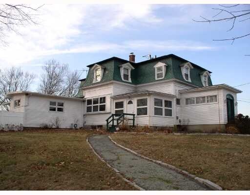

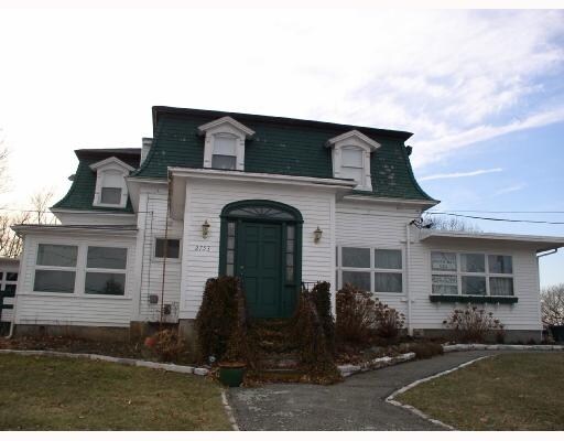
Property Detail
2753 Main Rd
Commercialofficeresidentialmixeduse
Newport
R80
Rhode Island
AE The base floodplain where base flood elevations are provided. AE Zones are now used on new format FIRMs instead of A1-A30 Zones.
8.20 AC
2025
Newport County
2025
Providence
041702
Providence-Warwick, RI-MA
4,927 SF
TIVE-000408-000000-000115
NEARBY LISTINGS FOR SALE OR LEASE
-
-
View all Tiverton listings for sale on LoopNet.com
DEMOGRAPHICS near 2753 Main Rd
1 mile
3 mile
5 mile
2025 Total Population
907
9,972
37,437
2030 Population
871
9,505
36,286
Pop Growth 2025-2030
(3.97%)
(4.68%)
(3.07%)
Average Age
50
48
47
2025 Total Households
398
4,180
15,323
HH Growth 2025-2030
(3.02%)
(3.88%)
(2.53%)
Median Household Inc
$130,000
$116,892
$115,690
Avg Household Size
2.20
2.30
2.30
2025 Avg HH Vehicles
2.00
2.00
2.00
Median Home Value
$569,728
$611,221
$560,101
Median Year Built
1968
1965
1970
Nearby Places
Map Layers
Map Styles
 Street
 Aerial
Layers
 Traffic
 Biking
Places
Listings with unknown addresses are not visible on the map
- Restaurants
- Banks
- Shops
- Fitness
- Groceries
PUBLIC TRANSPORTATION
AIRPORT
Rhode Island Tf Green International
Drive
Walk
Distance
Rhode Island Tf Green International
50 min
31.7 mi
Freight Ports
Port of New Bedford Harbor
Drive
Walk
Distance
Port of New Bedford Harbor
29 min
20.1 mi
SALE & LEASE HISTORY
LISTING DATE
SALE/LEASE

Sep 28, 2016
For Sale
Nearby Properties
Address
Land Use
TOTAL SIZE
Lot Size
Zoning
Address
Land Use
TOTAL SIZE
Lot Size
Zoning
27.66 AC
I
Address
Land Use
TOTAL SIZE
Lot Size
Zoning
42 AC
R20
Address
Land Use
TOTAL SIZE
Lot Size
Zoning
150,156 SF
8.77 AC
R40
Address
Land Use
TOTAL SIZE
Lot Size
Zoning
124,038 SF
74.50 AC
R60
Address
Land Use
TOTAL SIZE
Lot Size
Zoning
178,538 SF
17.27 AC
I
Address
Land Use
TOTAL SIZE
Lot Size
Zoning
144,773 SF
10.50 AC
R60
Address
Land Use
TOTAL SIZE
Lot Size
Zoning
10 AC
HC
Address
Land Use
TOTAL SIZE
Lot Size
Zoning
84,000 SF
3.31 AC
I
Address
Land Use
TOTAL SIZE
Lot Size
Zoning
48,351 SF
10.75 AC
R20
Address
Land Use
TOTAL SIZE
Lot Size
Zoning
22,847 SF
6.06 AC
GC
Address
Land Use
TOTAL SIZE
Lot Size
Zoning
33,916 SF
5.75 AC
TC
Address
Land Use
TOTAL SIZE
Lot Size
Zoning
2.81 AC
C
Address
Land Use
TOTAL SIZE
Lot Size
Zoning
4,850 SF
26.29 AC
W
Address
Land Use
TOTAL SIZE
Lot Size
Zoning
229.01 AC
OS
Address
Land Use
TOTAL SIZE
Lot Size
Zoning
35,250 SF
R30
Address
Land Use
TOTAL SIZE
Lot Size
Zoning
1,834 SF
205.53 AC
R80
Address
Land Use
TOTAL SIZE
Lot Size
Zoning
107.70 AC
R10
Address
Land Use
TOTAL SIZE
Lot Size
Zoning
2,016 SF
25.73 AC
R40
Address
Land Use
TOTAL SIZE
Lot Size
Zoning
44.64 AC
I
Address
Land Use
TOTAL SIZE
Lot Size
Zoning
14,306 SF
1.15 AC
GC
Address
Land Use
TOTAL SIZE
Lot Size
Zoning
5 AC
R80
Address
Land Use
TOTAL SIZE
Lot Size
Zoning
16,420 SF
1.79 AC
R40
Address
Land Use
TOTAL SIZE
Lot Size
Zoning
32 AC
R80
Address
Land Use
TOTAL SIZE
Lot Size
Zoning
12,565 SF
0.87 AC
R20
Address
Land Use
TOTAL SIZE
Lot Size
Zoning
5.51 AC
R80
Address
Land Use
TOTAL SIZE
Lot Size
Zoning
29.21 AC
R80
Address
Land Use
TOTAL SIZE
Lot Size
Zoning
28.59 AC
R80
Address
Land Use
TOTAL SIZE
Lot Size
Zoning
2.15 AC
R40
Address
Land Use
TOTAL SIZE
Lot Size
Zoning
1,896 SF
19.20 AC
R80
Address
Land Use
TOTAL SIZE
Lot Size
Zoning
2.05 AC
R10
The World's #1 Commercial Real Estate Marketplace
Connect with us
© 2026 CoStar Group
The information above has been obtained from sources believed reliable. While we do not doubt its accuracy we have not verified it and make no guarantee, warranty or representation about it. It is your responsibility to independently confirm its accuracy and completeness. Any projections, opinions, assumptions, or estimates used are for example only and do not represent the current or future performance of the property. The value of this transaction to you depends on tax and other factors which should be evaluated by your tax, financial, and legal advisors. You and your advisors should conduct a careful, independent investigation of the property to determine to your satisfaction the suitability of the property for your needs.