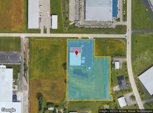
Property Record
2755 Atlas Ave, Oshkosh, WI 54904
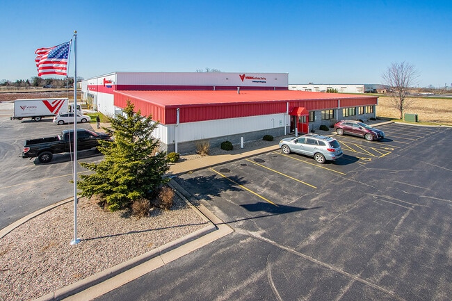
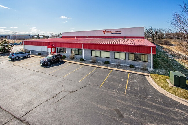
This Property Is For Sale
NEARBY LISTINGS FOR SALE OR LEASE
Property Detail
2755 Atlas Ave
Oshkosh-Neenah, WI
Certified Survey Map No 5998
13-29103009
LOT 1 CSM 5998 DOC #1415899 R OF D AND LOT 2 CSM 7419 DOC#1779355 R OF D
Commercialnec
Winnebago
X
Wisconsin
55039C0100F
1,2
2024
6.94 AC
2024
Appleton/Oshkosh
001801
Other Market Areas
25,000 SF
DEMOGRAPHICS near 2755 Atlas Ave
1 Mile
3 Mile
5 Mile
2024 Total Population
1,622
22,855
64,370
2029 Population
1,629
23,077
64,734
Pop Growth 2024-2029
+ 0.43%
+ 0.97%
+ 0.57%
Average Age
44
42
39
2024 Total Households
726
10,513
27,728
HH Growth 2024-2029
+ 0.14%
+ 1.05%
+ 0.70%
Median Household Inc
$83,544
$59,258
$58,859
Avg Household Size
2.20
2.10
2.20
2024 Avg HH Vehicles
2.00
2.00
2.00
Median Home Value
$220,352
$176,865
$170,259
Median Year Built
1992
1987
1973
Nearby Places
Map Layers
Map Styles
 Street
 Aerial
- Restaurants
- Banks
- Shops
- Fitness
- Groceries
PUBLIC TRANSPORTATION
AIRPORT
Appleton International
DRIVE
WALK
Distance
Appleton International
32 min
24.4 mi
Freight Ports
Port Milwaukee
DRIVE
WALK
Distance
Port Milwaukee
103 min
86.8 mi
Nearby Properties
Address
Land Use
TOTAL SIZE
Lot Size
Zoning
Address
Land Use
TOTAL SIZE
Lot Size
Zoning
931,304 SF
107 AC
M3
Address
Land Use
TOTAL SIZE
Lot Size
Zoning
15.37 AC
SMU-PD
Address
Land Use
TOTAL SIZE
Lot Size
Zoning
195,810 SF
31.08 AC
MR-20
Address
Land Use
TOTAL SIZE
Lot Size
Zoning
208,278 SF
22.77 AC
C2
Address
Land Use
TOTAL SIZE
Lot Size
Zoning
255,080 SF
21.29 AC
MR-12
Address
Land Use
TOTAL SIZE
Lot Size
Zoning
570,585 SF
81.26 AC
M2
Address
Land Use
TOTAL SIZE
Lot Size
Zoning
18.38 AC
UIPD
Address
Land Use
TOTAL SIZE
Lot Size
Zoning
14.77 AC
SMU-PD
Address
Land Use
TOTAL SIZE
Lot Size
Zoning
41.70 AC
HI
Address
Land Use
TOTAL SIZE
Lot Size
Zoning
19,488 SF
16.43 AC
C-2
Address
Land Use
TOTAL SIZE
Lot Size
Zoning
136,368 SF
10.24 AC
C-2PD
Address
Land Use
TOTAL SIZE
Lot Size
Zoning
271,088 SF
36.80 AC
M3
Address
Land Use
TOTAL SIZE
Lot Size
Zoning
53,998 SF
3.63 AC
C2
Address
Land Use
TOTAL SIZE
Lot Size
Zoning
341,904 SF
40.71 AC
HI
Address
Land Use
TOTAL SIZE
Lot Size
Zoning
107,778 SF
8.57 AC
SMUPD
Address
Land Use
TOTAL SIZE
Lot Size
Zoning
25,456 SF
1.74 AC
R1;SINGLE
Address
Land Use
TOTAL SIZE
Lot Size
Zoning
9.86 AC
MR-12
Address
Land Use
TOTAL SIZE
Lot Size
Zoning
92,958 SF
1.02 AC
C2
Address
Land Use
TOTAL SIZE
Lot Size
Zoning
34,340 SF
8.56 AC
C2
Address
Land Use
TOTAL SIZE
Lot Size
Zoning
114,338 SF
10.20 AC
C2
Address
Land Use
TOTAL SIZE
Lot Size
Zoning
32,430 SF
7.44 AC
M1
Address
Land Use
TOTAL SIZE
Lot Size
Zoning
28,512 SF
6.20 AC
M1
Address
Land Use
TOTAL SIZE
Lot Size
Zoning
14,796 SF
18.51 AC
MR-12
Address
Land Use
TOTAL SIZE
Lot Size
Zoning
100,361 SF
14.25 AC
SMU-PD
Address
Land Use
TOTAL SIZE
Lot Size
Zoning
96,516 SF
2.62 AC
R5
Address
Land Use
TOTAL SIZE
Lot Size
Zoning
88,128 SF
6.33 AC
MR-12
Address
Land Use
TOTAL SIZE
Lot Size
Zoning
42,092 SF
3.21 AC
C2
Address
Land Use
TOTAL SIZE
Lot Size
Zoning
83,538 SF
9.72 AC
M1
Address
Land Use
TOTAL SIZE
Lot Size
Zoning
129,759 SF
8.52 AC
SMU
Address
Land Use
TOTAL SIZE
Lot Size
Zoning
26,375 SF
33.11 AC
C2
The World's #1 Commercial Real Estate Marketplace
Connect with us
© 2026 CoStar Group
The information above has been obtained from sources believed reliable. While we do not doubt its accuracy we have not verified it and make no guarantee, warranty or representation about it. It is your responsibility to independently confirm its accuracy and completeness. Any projections, opinions, assumptions, or estimates used are for example only and do not represent the current or future performance of the property. The value of this transaction to you depends on tax and other factors which should be evaluated by your tax, financial, and legal advisors. You and your advisors should conduct a careful, independent investigation of the property to determine to your satisfaction the suitability of the property for your needs.