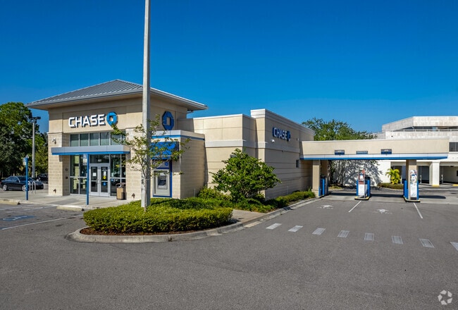
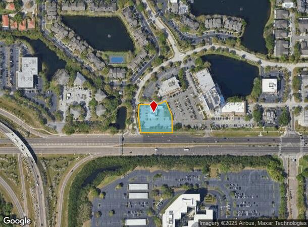
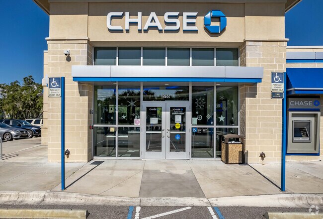
Property Record
2755 Ulmerton Rd, Clearwater, FL 33762

NEARBY LISTINGS FOR SALE OR LEASE
Property Detail
2755 Ulmerton Rd
02-30-16-00000-430-0400
Part Of Sw 1/4 Of Se 1/4
Financialbuilding
PART OF SW 1/4 OF SE 1/4 OF SEC 2-30-16 DESC FROM SW COR OF SE 14/ OF SEC TH N00D1021E 88FT TO N R/W OF ULMERTON RD TH S89D5129E 94.62FT FOR POB TH N08D2043W 117.28 FT TH CUR RT RAD 350FT ARC 77.64FT CB N06D2947E 77.48FT TH S89D5129E 119.81FT TH CUR
AE
Pinellas
12103C0143H
Florida
2024
0.99 AC
2025
Gateway
024509
Tampa/St Petersburg
4,468 SF
Tampa-St. Petersburg-Clearwater, FL
DEMOGRAPHICS near 2755 Ulmerton Rd
1 Mile
3 Mile
5 Mile
2024 Total Population
5,225
34,552
146,030
2029 Population
5,361
34,666
147,295
Pop Growth 2024-2029
+ 2.60%
+ 0.33%
+ 0.87%
Average Age
42
42
44
2024 Total Households
2,573
17,564
69,145
HH Growth 2024-2029
+ 2.06%
+ 0.03%
+ 0.81%
Median Household Inc
$104,979
$61,151
$57,345
Avg Household Size
2.00
1.90
2.00
2024 Avg HH Vehicles
2.00
1.00
1.00
Median Home Value
$383,915
$234,980
$209,387
Median Year Built
1987
1984
1979
Nearby Places
Map Layers
Map Styles
 Street
 Aerial
- Restaurants
- Banks
- Shops
- Fitness
- Groceries
PUBLIC TRANSPORTATION
AIRPORT
St Pete-Clearwater International
DRIVE
WALK
Distance
St Pete-Clearwater International
11 min
3.1 mi
Tampa International
DRIVE
WALK
Distance
Tampa International
22 min
13.3 mi
Freight Ports
Port of Tampa Bay
DRIVE
WALK
Distance
Port of Tampa Bay
31 min
18.7 mi
Nearby Properties
Address
Land Use
TOTAL SIZE
Lot Size
Zoning
Address
Land Use
TOTAL SIZE
Lot Size
Zoning
795,890 SF
69.11 AC
M1
Address
Land Use
TOTAL SIZE
Lot Size
Zoning
130,544 SF
1,313.50 AC
PCAIRPOR
Address
Land Use
TOTAL SIZE
Lot Size
Zoning
1,160,631 SF
28.08 AC
Address
Land Use
TOTAL SIZE
Lot Size
Zoning
1,232,878 SF
12.64 AC
Address
Land Use
TOTAL SIZE
Lot Size
Zoning
551,317 SF
52.55 AC
Address
Land Use
TOTAL SIZE
Lot Size
Zoning
749,164 SF
7.11 AC
Address
Land Use
TOTAL SIZE
Lot Size
Zoning
428,587 SF
14.35 AC
Address
Land Use
TOTAL SIZE
Lot Size
Zoning
484,229 SF
28 AC
Address
Land Use
TOTAL SIZE
Lot Size
Zoning
466,420 SF
2.60 AC
Address
Land Use
TOTAL SIZE
Lot Size
Zoning
171,420 SF
300.24 AC
M1
Address
Land Use
TOTAL SIZE
Lot Size
Zoning
350,604 SF
13.21 AC
Address
Land Use
TOTAL SIZE
Lot Size
Zoning
429,226 SF
0.85 AC
Address
Land Use
TOTAL SIZE
Lot Size
Zoning
416,482 SF
14.93 AC
Address
Land Use
TOTAL SIZE
Lot Size
Zoning
346,420 SF
17.95 AC
Address
Land Use
TOTAL SIZE
Lot Size
Zoning
401,627 SF
0.66 AC
Address
Land Use
TOTAL SIZE
Lot Size
Zoning
308,107 SF
32.37 AC
Address
Land Use
TOTAL SIZE
Lot Size
Zoning
240,736 SF
58.40 AC
Address
Land Use
TOTAL SIZE
Lot Size
Zoning
402,681 SF
18.40 AC
Address
Land Use
TOTAL SIZE
Lot Size
Zoning
337,137 SF
26.72 AC
M1
Address
Land Use
TOTAL SIZE
Lot Size
Zoning
255,548 SF
21.69 AC
RPD10
Address
Land Use
TOTAL SIZE
Lot Size
Zoning
243,101 SF
24.86 AC
Address
Land Use
TOTAL SIZE
Lot Size
Zoning
311,000 SF
15.50 AC
Address
Land Use
TOTAL SIZE
Lot Size
Zoning
446,556 SF
14.95 AC
M1
Address
Land Use
TOTAL SIZE
Lot Size
Zoning
572,006 SF
13.01 AC
Address
Land Use
TOTAL SIZE
Lot Size
Zoning
396,822 SF
36.20 AC
RPD5
Address
Land Use
TOTAL SIZE
Lot Size
Zoning
249,361 SF
20.79 AC
Address
Land Use
TOTAL SIZE
Lot Size
Zoning
362,618 SF
40.19 AC
R6
Address
Land Use
TOTAL SIZE
Lot Size
Zoning
322,480 SF
26.15 AC
Address
Land Use
TOTAL SIZE
Lot Size
Zoning
286,406 SF
15.26 AC
Address
Land Use
TOTAL SIZE
Lot Size
Zoning
250,000 SF
21.44 AC
The World's #1 Commercial Real Estate Marketplace
Connect with us
© 2025 CoStar Group
The information above has been obtained from sources believed reliable. While we do not doubt its accuracy we have not verified it and make no guarantee, warranty or representation about it. It is your responsibility to independently confirm its accuracy and completeness. Any projections, opinions, assumptions, or estimates used are for example only and do not represent the current or future performance of the property. The value of this transaction to you depends on tax and other factors which should be evaluated by your tax, financial, and legal advisors. You and your advisors should conduct a careful, independent investigation of the property to determine to your satisfaction the suitability of the property for your needs.