Property Record
2757 Shell Beach Rd, Pismo Beach, CA 93449
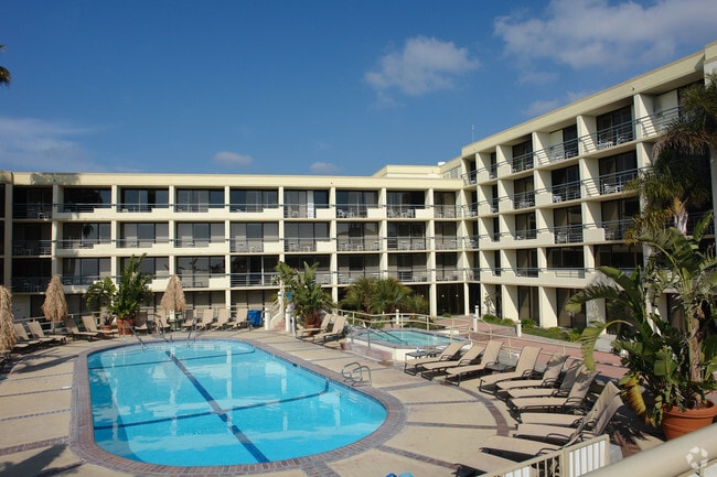

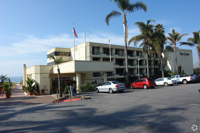
Property Detail
2757 Shell Beach Rd
San Luis Obispo-Paso Robles, CA
CY PB PM 35/77 PTN
010-041-044
San Luis Obispo
Motel
California
R4
4,5
VE and V1-30 Coastal areas with a 1% or greater chance of flooding and an additional hazard associated with storm waves. These areas have a 26% chance of flooding over the life of a 30-year mortgage.
5.60 AC
2024
San Luis Obispo/Paso Robles
2025
San Luis Obispo/Paso Robles
011704
NEARBY LISTINGS FOR SALE OR LEASE
-
-
View all Pismo Beach listings for sale on LoopNet.com
DEMOGRAPHICS near 2757 Shell Beach Rd
1 mile
3 mile
5 mile
2025 Total Population
2,178
5,670
16,502
2030 Population
2,282
5,789
16,783
Pop Growth 2025-2030
+ 4.78%
+ 2.10%
+ 1.70%
Average Age
50
50
48
2025 Total Households
1,049
2,806
7,725
HH Growth 2025-2030
+ 4.48%
+ 1.96%
+ 1.70%
Median Household Inc
$157,127
$119,494
$108,787
Avg Household Size
2.00
2.00
2.10
2025 Avg HH Vehicles
2.00
2.00
2.00
Median Home Value
$1,129,888
$1,117,914
$1,038,440
Median Year Built
1980
1982
1981
Nearby Places
Map Layers
Map Styles
 Street
 Aerial
Layers
 Traffic
 Biking
Places
Listings with unknown addresses are not visible on the map
- Restaurants
- Banks
- Shops
- Fitness
- Groceries
PUBLIC TRANSPORTATION
COMMUTER RAIL
Grover Beach Amtrak (Pacific Surfliner - Amtrak)
Drive
Walk
Distance
Grover Beach Amtrak (Pacific Surfliner - Amtrak)
8 min
5.1 mi
San Luis Obispo (Coast Starlight - Amtrak, Pacific Surfliner - Amtrak)
Drive
Walk
Distance
San Luis Obispo (Coast Starlight - Amtrak, Pacific Surfliner - Amtrak)
13 min
9.8 mi
AIRPORT
San Luis County Regional
Drive
Walk
Distance
San Luis County Regional
17 min
8.1 mi
Freight Ports
The Port of Hueneme
Drive
Walk
Distance
The Port of Hueneme
160 min
124.4 mi
Nearby Properties
Address
Land Use
TOTAL SIZE
Lot Size
Zoning
Address
Land Use
TOTAL SIZE
Lot Size
Zoning
77,687 SF
4.80 AC
R4
Address
Land Use
TOTAL SIZE
Lot Size
Zoning
8,510 SF
104 AC
REC
Address
Land Use
TOTAL SIZE
Lot Size
Zoning
1.65 AC
CR
Address
Land Use
TOTAL SIZE
Lot Size
Zoning
4,338 SF
11.10 AC
REC
Address
Land Use
TOTAL SIZE
Lot Size
Zoning
40,860 SF
3.72 AC
CRS
Address
Land Use
TOTAL SIZE
Lot Size
Zoning
14,860 SF
0.30 AC
CR
Address
Land Use
TOTAL SIZE
Lot Size
Zoning
880 AC
RL
Address
Land Use
TOTAL SIZE
Lot Size
Zoning
58,544 SF
9.51 AC
R4
Address
Land Use
TOTAL SIZE
Lot Size
Zoning
64,430 SF
2.20 AC
R4
Address
Land Use
TOTAL SIZE
Lot Size
Zoning
32,163 SF
1.50 AC
R4
Address
Land Use
TOTAL SIZE
Lot Size
Zoning
64,198 SF
8.53 AC
R4
Address
Land Use
TOTAL SIZE
Lot Size
Zoning
12.70 AC
REC
Address
Land Use
TOTAL SIZE
Lot Size
Zoning
95 AC
IND
Address
Land Use
TOTAL SIZE
Lot Size
Zoning
0.36 AC
CR
Address
Land Use
TOTAL SIZE
Lot Size
Zoning
1,093 SF
3.38 AC
REC
Address
Land Use
TOTAL SIZE
Lot Size
Zoning
38,764 SF
4.37 AC
R4
Address
Land Use
TOTAL SIZE
Lot Size
Zoning
2,476 SF
0.14 AC
CR
Address
Land Use
TOTAL SIZE
Lot Size
Zoning
Address
Land Use
TOTAL SIZE
Lot Size
Zoning
0.48 AC
R2
Address
Land Use
TOTAL SIZE
Lot Size
Zoning
8,092 SF
0.14 AC
CR
Address
Land Use
TOTAL SIZE
Lot Size
Zoning
3,025 SF
0.24 AC
R1
Address
Land Use
TOTAL SIZE
Lot Size
Zoning
4,300 SF
0.07 AC
CR
Address
Land Use
TOTAL SIZE
Lot Size
Zoning
16,144 SF
1.05 AC
RMF
Address
Land Use
TOTAL SIZE
Lot Size
Zoning
7,934 SF
0.60 AC
R4
Address
Land Use
TOTAL SIZE
Lot Size
Zoning
18,131 SF
1.82 AC
RMF
Address
Land Use
TOTAL SIZE
Lot Size
Zoning
672 SF
0.86 AC
RMF
Address
Land Use
TOTAL SIZE
Lot Size
Zoning
7,908 SF
0.28 AC
Address
Land Use
TOTAL SIZE
Lot Size
Zoning
0.21 AC
CR
Address
Land Use
TOTAL SIZE
Lot Size
Zoning
21,157 SF
1.50 AC
C1
The World's #1 Commercial Real Estate Marketplace
Connect with us
© 2026 CoStar Group
The information above has been obtained from sources believed reliable. While we do not doubt its accuracy we have not verified it and make no guarantee, warranty or representation about it. It is your responsibility to independently confirm its accuracy and completeness. Any projections, opinions, assumptions, or estimates used are for example only and do not represent the current or future performance of the property. The value of this transaction to you depends on tax and other factors which should be evaluated by your tax, financial, and legal advisors. You and your advisors should conduct a careful, independent investigation of the property to determine to your satisfaction the suitability of the property for your needs.