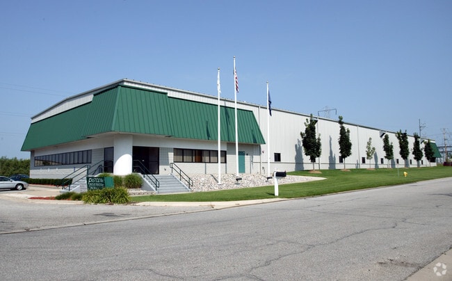
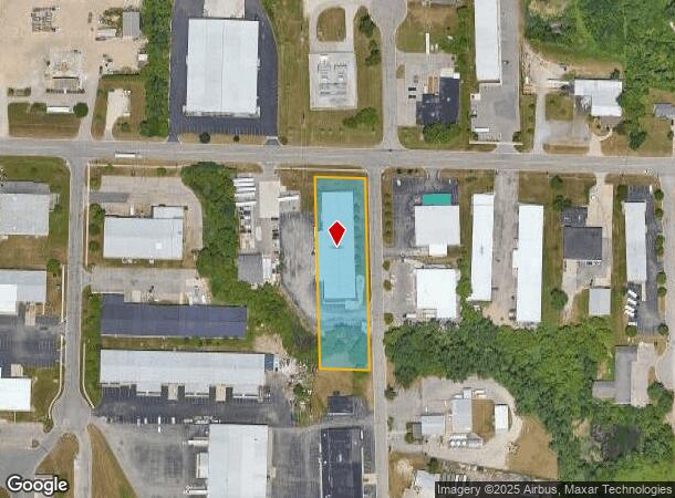
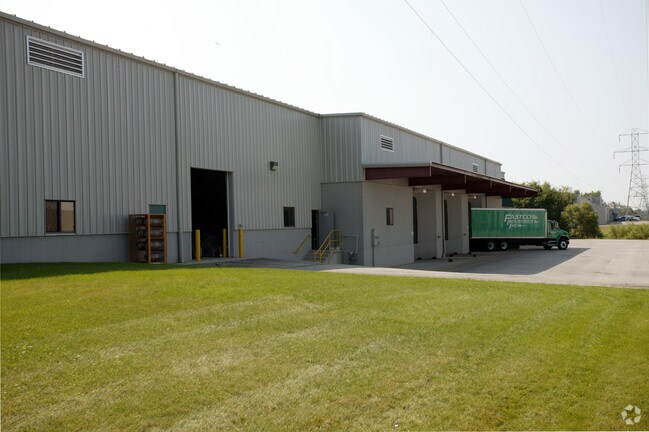
Property Record
2759 Mullins Ct Nw, Grand Rapids, MI 49534
NEARBY LISTINGS FOR SALE OR LEASE
-
-
-
-
-
-
No Photo
-
-
View all Grand Rapids listings for sale on LoopNet.com
Property Detail
2759 Mullins Ct Nw
41-13-08-201-002
N 540 FT OF FOL DESC - PART NE 1/4 COM 229.97 FT 90D 00M 00S E ALONG N SEC LINE FROM N 1/4 COR TH S 3D 07M 10S E PAR WITH N&S
Manufacturinglight
Kent
X
Michigan
26081C0270D
1.61 AC
2024
W Grand Rapids/Walker
2025
West Michigan
011701
Grand Rapids-Wyoming, MI
22,768 SF
DEMOGRAPHICS near 2759 Mullins Ct Nw
1 Mile
3 Mile
5 Mile
2024 Total Population
2,267
27,787
85,205
2029 Population
2,267
28,104
85,983
Pop Growth 2024-2029
0.00%
+ 1.14%
+ 0.91%
Average Age
39
40
38
2024 Total Households
826
11,284
35,146
HH Growth 2024-2029
(0.12%)
+ 1.12%
+ 0.90%
Median Household Inc
$89,099
$75,711
$65,575
Avg Household Size
2.70
2.40
2.40
2024 Avg HH Vehicles
2.00
2.00
2.00
Median Home Value
$281,723
$248,510
$226,018
Median Year Built
1993
1982
1970
Nearby Places
Map Layers
Map Styles
 Street
 Aerial
- Restaurants
- Banks
- Shops
- Fitness
- Groceries
PUBLIC TRANSPORTATION
COMMUTER RAIL
Grand Rapids Vernon J. Ehlers Station (Pere Marquette - Amtrak)
DRIVE
WALK
Distance
Grand Rapids Vernon J. Ehlers Station (Pere Marquette - Amtrak)
11 min
9.1 mi
AIRPORT
Gerald R Ford International
DRIVE
WALK
Distance
Gerald R Ford International
30 min
22.1 mi
Freight Ports
Port Milwaukee
DRIVE
WALK
Distance
Port Milwaukee
309 min
264.1 mi
Nearby Properties
Address
Land Use
TOTAL SIZE
Lot Size
Zoning
Address
Land Use
TOTAL SIZE
Lot Size
Zoning
352,362 SF
61.33 AC
IPUD
Address
Land Use
TOTAL SIZE
Lot Size
Zoning
546,366 SF
28.40 AC
MH
Address
Land Use
TOTAL SIZE
Lot Size
Zoning
389,181 SF
51.01 AC
RPUD - 2
Address
Land Use
TOTAL SIZE
Lot Size
Zoning
32.89 AC
TN-LDR
Address
Land Use
TOTAL SIZE
Lot Size
Zoning
455,639 SF
42.06 AC
MH
Address
Land Use
TOTAL SIZE
Lot Size
Zoning
340,744 SF
69.50 AC
RPUD - 2
Address
Land Use
TOTAL SIZE
Lot Size
Zoning
337,324 SF
10.15 AC
C-3
Address
Land Use
TOTAL SIZE
Lot Size
Zoning
Address
Land Use
TOTAL SIZE
Lot Size
Zoning
278,832 SF
NOT APP
Address
Land Use
TOTAL SIZE
Lot Size
Zoning
410,206 SF
54.36 AC
MH
Address
Land Use
TOTAL SIZE
Lot Size
Zoning
183,517 SF
44.93 AC
ML
Address
Land Use
TOTAL SIZE
Lot Size
Zoning
198,000 SF
NOT APP
Address
Land Use
TOTAL SIZE
Lot Size
Zoning
190,882 SF
30.17 AC
MP
Address
Land Use
TOTAL SIZE
Lot Size
Zoning
113,016 SF
33.69 AC
IPUD
Address
Land Use
TOTAL SIZE
Lot Size
Zoning
132,680 SF
17.24 AC
IPUD
Address
Land Use
TOTAL SIZE
Lot Size
Zoning
162,765 SF
22.63 AC
MP
Address
Land Use
TOTAL SIZE
Lot Size
Zoning
670,966 SF
40.67 AC
C-3
Address
Land Use
TOTAL SIZE
Lot Size
Zoning
59.89 AC
R-4
Address
Land Use
TOTAL SIZE
Lot Size
Zoning
267,000 SF
15.63 AC
IPUD
Address
Land Use
TOTAL SIZE
Lot Size
Zoning
147,232 SF
18.42 AC
ARM - MULT
Address
Land Use
TOTAL SIZE
Lot Size
Zoning
247,168 SF
9.60 AC
MP
Address
Land Use
TOTAL SIZE
Lot Size
Zoning
332,315 SF
17.71 AC
MP
Address
Land Use
TOTAL SIZE
Lot Size
Zoning
250,469 SF
14.11 AC
ML
Address
Land Use
TOTAL SIZE
Lot Size
Zoning
134,118 SF
17.04 AC
IPUD
Address
Land Use
TOTAL SIZE
Lot Size
Zoning
200,831 SF
11.69 AC
MH
Address
Land Use
TOTAL SIZE
Lot Size
Zoning
140,841 SF
8.96 AC
Address
Land Use
TOTAL SIZE
Lot Size
Zoning
285,000 SF
17.66 AC
MH
Address
Land Use
TOTAL SIZE
Lot Size
Zoning
197,220 SF
10.94 AC
MP
Address
Land Use
TOTAL SIZE
Lot Size
Zoning
222,833 SF
20.49 AC
MH
Address
Land Use
TOTAL SIZE
Lot Size
Zoning
160,097 SF
11.58 AC
C-3
The World's #1 Commercial Real Estate Marketplace
Connect with us
© 2025 CoStar Group
The information above has been obtained from sources believed reliable. While we do not doubt its accuracy we have not verified it and make no guarantee, warranty or representation about it. It is your responsibility to independently confirm its accuracy and completeness. Any projections, opinions, assumptions, or estimates used are for example only and do not represent the current or future performance of the property. The value of this transaction to you depends on tax and other factors which should be evaluated by your tax, financial, and legal advisors. You and your advisors should conduct a careful, independent investigation of the property to determine to your satisfaction the suitability of the property for your needs.