Property Record
2760 Stringtown Rd, Shepherd, TX 77371

Save to a Folder
{{folder.Name}}
{{folder.ListingIds.length}} Properties
{{folder.ListingIds.length}} Property
Create a New Folder
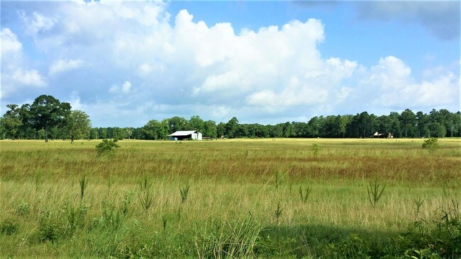
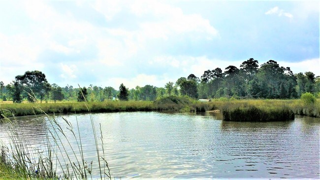
Property Detail
2760 Stringtown Rd
46533
A144 WILLIAM HAYS, TRACT 46, ACRES 69.75
Farms
San Jacinto
B and X Area of moderate flood hazard, usually the area between the limits of the 100-year and 500-year floods.
Texas
2025
69.75 AC
2025
San Jacinto County
200104
Houston
1,888 SF
Houston-Pasadena-The Woodlands, TX
NEARBY LISTINGS FOR SALE OR LEASE
-
-
View all Shepherd listings for sale on LoopNet.com
DEMOGRAPHICS near 2760 Stringtown Rd
1 mile
3 mile
5 mile
2025 Total Population
385
3,554
7,546
2030 Population
405
3,773
8,100
Pop Growth 2025-2030
+ 5.19%
+ 6.16%
+ 7.34%
Average Age
38
38
38
2025 Total Households
132
1,230
2,638
HH Growth 2025-2030
+ 4.55%
+ 5.93%
+ 7.16%
Median Household Inc
$102,539
$79,629
$80,089
Avg Household Size
3.00
2.90
2.80
2025 Avg HH Vehicles
2.00
2.00
2.00
Median Home Value
$84,090
$128,829
$148,214
Median Year Built
1995
1993
1991
Nearby Places
Map Layers
Map Styles
 Street
 Aerial
Layers
 Traffic
 Biking
Places
Listings with unknown addresses are not visible on the map
- Restaurants
- Banks
- Shops
- Fitness
- Groceries
SALE & LEASE HISTORY
LISTING DATE
SALE/LEASE

Aug 26, 2017
For Sale
Nearby Properties
Address
Land Use
TOTAL SIZE
Lot Size
Zoning
Address
Land Use
TOTAL SIZE
Lot Size
Zoning
132,704 SF
18.73 AC
Address
Land Use
TOTAL SIZE
Lot Size
Zoning
12,746 SF
1.35 AC
Address
Land Use
TOTAL SIZE
Lot Size
Zoning
8,386 SF
42.20 AC
Address
Land Use
TOTAL SIZE
Lot Size
Zoning
12,482 SF
9.94 AC
Address
Land Use
TOTAL SIZE
Lot Size
Zoning
3,500 SF
1.33 AC
Address
Land Use
TOTAL SIZE
Lot Size
Zoning
6,018 SF
3.16 AC
Address
Land Use
TOTAL SIZE
Lot Size
Zoning
576 SF
182.90 AC
Address
Land Use
TOTAL SIZE
Lot Size
Zoning
5,352 SF
17.98 AC
Address
Land Use
TOTAL SIZE
Lot Size
Zoning
Address
Land Use
TOTAL SIZE
Lot Size
Zoning
5,424 SF
43.73 AC
Address
Land Use
TOTAL SIZE
Lot Size
Zoning
3,747 SF
5.73 AC
Address
Land Use
TOTAL SIZE
Lot Size
Zoning
3,634 SF
13.33 AC
Address
Land Use
TOTAL SIZE
Lot Size
Zoning
2,508 SF
8.36 AC
Address
Land Use
TOTAL SIZE
Lot Size
Zoning
2,738 SF
1.29 AC
Address
Land Use
TOTAL SIZE
Lot Size
Zoning
3,132 SF
22 AC
Address
Land Use
TOTAL SIZE
Lot Size
Zoning
2,164 SF
11.20 AC
Address
Land Use
TOTAL SIZE
Lot Size
Zoning
1,388.18 AC
Address
Land Use
TOTAL SIZE
Lot Size
Zoning
1,834 SF
14.23 AC
Address
Land Use
TOTAL SIZE
Lot Size
Zoning
2,969 SF
8.36 AC
Address
Land Use
TOTAL SIZE
Lot Size
Zoning
2,707 SF
5 AC
Address
Land Use
TOTAL SIZE
Lot Size
Zoning
3,792 SF
1.54 AC
Address
Land Use
TOTAL SIZE
Lot Size
Zoning
2,696 SF
11.77 AC
Address
Land Use
TOTAL SIZE
Lot Size
Zoning
3,136 SF
31.82 AC
Address
Land Use
TOTAL SIZE
Lot Size
Zoning
2,600 SF
75.57 AC
Address
Land Use
TOTAL SIZE
Lot Size
Zoning
3,267 SF
5.22 AC
Address
Land Use
TOTAL SIZE
Lot Size
Zoning
2,388 SF
10 AC
Address
Land Use
TOTAL SIZE
Lot Size
Zoning
3,210 SF
57.91 AC
Address
Land Use
TOTAL SIZE
Lot Size
Zoning
3,368 SF
25.25 AC
Address
Land Use
TOTAL SIZE
Lot Size
Zoning
2,220 SF
16.82 AC
Address
Land Use
TOTAL SIZE
Lot Size
Zoning
1,560 SF
2 AC
The World's #1 Commercial Real Estate Marketplace
Connect with us
© 2026 CoStar Group
The information above has been obtained from sources believed reliable. While we do not doubt its accuracy we have not verified it and make no guarantee, warranty or representation about it. It is your responsibility to independently confirm its accuracy and completeness. Any projections, opinions, assumptions, or estimates used are for example only and do not represent the current or future performance of the property. The value of this transaction to you depends on tax and other factors which should be evaluated by your tax, financial, and legal advisors. You and your advisors should conduct a careful, independent investigation of the property to determine to your satisfaction the suitability of the property for your needs.