Property Record
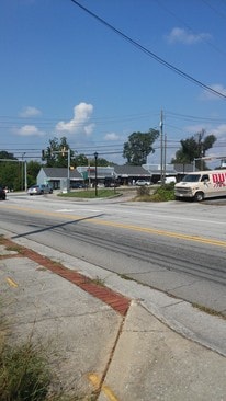
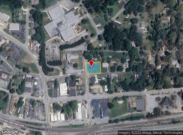
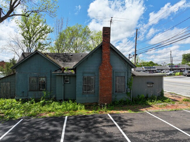
5720 Mulberry St, Austell, GA 30106

This Property Is For Sale
NEARBY LISTINGS FOR SALE OR LEASE
Property Detail
5720 Mulberry St
Atlanta-Sandy Springs-Roswell, GA
Homesite
18-0025-0-003-0
Cobb
Sfr
Georgia
X
0.40 AC
13067C0184H
Douglasville/Lithia Springs
1,708 SF
Atlanta
DEMOGRAPHICS near 5720 Mulberry St
1 Mile
3 Mile
5 Mile
2024 Total Population
5,220
49,867
134,242
2029 Population
5,384
51,047
137,595
Pop Growth 2024-2029
+ 3.14%
+ 2.37%
+ 2.50%
Average Age
37
37
38
2024 Total Households
1,939
18,662
49,307
HH Growth 2024-2029
+ 3.20%
+ 2.39%
+ 2.48%
Median Household Inc
$57,499
$60,507
$65,751
Avg Household Size
2.70
2.60
2.60
2024 Avg HH Vehicles
2.00
2.00
2.00
Median Home Value
$210,937
$201,464
$226,987
Median Year Built
1986
1986
1986
Nearby Places
- Restaurants
- Banks
- Shops
- Fitness
- Groceries
PUBLIC TRANSPORTATION
AIRPORT
Hartsfield - Jackson Atlanta International
DRIVE
WALK
Distance
Hartsfield - Jackson Atlanta International
39 min
25.8 mi
Freight Ports
Georgia Ports - Savannah
DRIVE
WALK
Distance
Georgia Ports - Savannah
302 min
265.2 mi
Nearby Properties
Address
Land Use
TOTAL SIZE
Lot Size
Zoning
Address
Land Use
TOTAL SIZE
Lot Size
Zoning
840,110 SF
53.36 AC
PUD
Address
Land Use
TOTAL SIZE
Lot Size
Zoning
320,073 SF
38.78 AC
R-MF
Address
Land Use
TOTAL SIZE
Lot Size
Zoning
272,170 SF
26.40 AC
RM-12
Address
Land Use
TOTAL SIZE
Lot Size
Zoning
318,456 SF
30.91 AC
R-MF
Address
Land Use
TOTAL SIZE
Lot Size
Zoning
285,933 SF
46.22 AC
R-MF
Address
Land Use
TOTAL SIZE
Lot Size
Zoning
238,984 SF
17.51 AC
RM-12
Address
Land Use
TOTAL SIZE
Lot Size
Zoning
Address
Land Use
TOTAL SIZE
Lot Size
Zoning
240,612 SF
23.22 AC
R-6
Address
Land Use
TOTAL SIZE
Lot Size
Zoning
380,000 SF
33.97 AC
IL
Address
Land Use
TOTAL SIZE
Lot Size
Zoning
151,436 SF
11.42 AC
RM-12
Address
Land Use
TOTAL SIZE
Lot Size
Zoning
179,048 SF
25.97 AC
RM-12
Address
Land Use
TOTAL SIZE
Lot Size
Zoning
280,670 SF
23 AC
PVC
Address
Land Use
TOTAL SIZE
Lot Size
Zoning
312,093 SF
19.79 AC
PUD
Address
Land Use
TOTAL SIZE
Lot Size
Zoning
312,240 SF
24.58 AC
PUD
Address
Land Use
TOTAL SIZE
Lot Size
Zoning
225,600 SF
50.68 AC
LI-R
Address
Land Use
TOTAL SIZE
Lot Size
Zoning
122,697 SF
13.02 AC
PUD
Address
Land Use
TOTAL SIZE
Lot Size
Zoning
284,307 SF
15.75 AC
LI-R
Address
Land Use
TOTAL SIZE
Lot Size
Zoning
92,468 SF
13.69 AC
RM-8
Address
Land Use
TOTAL SIZE
Lot Size
Zoning
78.60 AC
R20
Address
Land Use
TOTAL SIZE
Lot Size
Zoning
247,000 SF
17.77 AC
PUD
Address
Land Use
TOTAL SIZE
Lot Size
Zoning
261,100 SF
18.52 AC
PUD
Address
Land Use
TOTAL SIZE
Lot Size
Zoning
222,414 SF
11.51 AC
PUD
Address
Land Use
TOTAL SIZE
Lot Size
Zoning
183,750 SF
10.39 AC
PUD
Address
Land Use
TOTAL SIZE
Lot Size
Zoning
182,092 SF
9.70 AC
IL
Address
Land Use
TOTAL SIZE
Lot Size
Zoning
63,424 SF
10.67 AC
RM-12
Address
Land Use
TOTAL SIZE
Lot Size
Zoning
115,088 SF
18.24 AC
PUD
Address
Land Use
TOTAL SIZE
Lot Size
Zoning
195,000 SF
17.55 AC
PUD
Address
Land Use
TOTAL SIZE
Lot Size
Zoning
224,000 SF
28.83 AC
PUD
Address
Land Use
TOTAL SIZE
Lot Size
Zoning
91,778 SF
7.94 AC
R-6
Address
Land Use
TOTAL SIZE
Lot Size
Zoning
153,774 SF
14.64 AC
PUD
The World's #1 Commercial Real Estate Marketplace
Connect with us
© 2025 CoStar Group
The information above has been obtained from sources believed reliable. While we do not doubt its accuracy we have not verified it and make no guarantee, warranty or representation about it. It is your responsibility to independently confirm its accuracy and completeness. Any projections, opinions, assumptions, or estimates used are for example only and do not represent the current or future performance of the property. The value of this transaction to you depends on tax and other factors which should be evaluated by your tax, financial, and legal advisors. You and your advisors should conduct a careful, independent investigation of the property to determine to your satisfaction the suitability of the property for your needs.