Property Record
27610 Crossover Rd, Katy, TX 77494

Property Detail
27610 Crossover Rd
Houston-Pasadena-The Woodlands, TX
0157 JAS CONNER, TRACT 13 (TR 4), ACRES 25.265, 20 % IN FORT BEND COUNTY MUD NO. 58 (M22), 80% IN CITY OF KATY (C06)
0157-01-013-0000-914
FORT BEND
Commercialacreage
Texas
Y
13
B and X Area of moderate flood hazard, usually the area between the limits of the 100-year and 500-year floods.
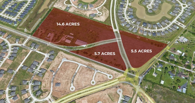
25.27 AC
2024
Katy/Grand Parkway West
2025
Houston
673108
NEARBY LISTINGS FOR SALE OR LEASE
DEMOGRAPHICS near 27610 Crossover Rd
1 mile
3 mile
5 mile
2025 Total Population
16,327
101,344
231,876
2030 Population
18,508
115,693
262,137
Pop Growth 2025-2030
+ 13.36%
+ 14.16%
+ 13.05%
Average Age
34
35
36
2025 Total Households
4,643
29,646
72,948
HH Growth 2025-2030
+ 13.93%
+ 14.76%
+ 13.38%
Median Household Inc
$176,849
$166,800
$137,525
Avg Household Size
3.50
3.40
3.20
2025 Avg HH Vehicles
2.00
2.00
2.00
Median Home Value
$659,383
$569,032
$466,334
Median Year Built
2011
2011
2010
Nearby Places
Map Layers
Map Styles
 Street
 Aerial
Layers
 Traffic
 Biking
Places
Listings with unknown addresses are not visible on the map
- Restaurants
- Banks
- Shops
- Fitness
- Groceries
SALE & LEASE HISTORY
LISTING DATE
SALE/LEASE

Mar 16, 2022
For Sale
Nearby Properties
Address
Land Use
TOTAL SIZE
Lot Size
Zoning
Address
Land Use
TOTAL SIZE
Lot Size
Zoning
39.24 AC
Address
Land Use
TOTAL SIZE
Lot Size
Zoning
1,655,920 SF
121.35 AC
Address
Land Use
TOTAL SIZE
Lot Size
Zoning
720,217 SF
65.17 AC
Address
Land Use
TOTAL SIZE
Lot Size
Zoning
610,000 SF
99.39 AC
Y
Address
Land Use
TOTAL SIZE
Lot Size
Zoning
350,883 SF
29.41 AC
Address
Land Use
TOTAL SIZE
Lot Size
Zoning
165,097 SF
43.81 AC
Address
Land Use
TOTAL SIZE
Lot Size
Zoning
185,815 SF
30.28 AC
Address
Land Use
TOTAL SIZE
Lot Size
Zoning
21.54 AC
Address
Land Use
TOTAL SIZE
Lot Size
Zoning
1,022 SF
21.43 AC
RAD
Address
Land Use
TOTAL SIZE
Lot Size
Zoning
Address
Land Use
TOTAL SIZE
Lot Size
Zoning
15.87 AC
Address
Land Use
TOTAL SIZE
Lot Size
Zoning
6.13 AC
Address
Land Use
TOTAL SIZE
Lot Size
Zoning
16.46 AC
Address
Land Use
TOTAL SIZE
Lot Size
Zoning
174,906 SF
31.18 AC
Address
Land Use
TOTAL SIZE
Lot Size
Zoning
678,028 SF
42.63 AC
Address
Land Use
TOTAL SIZE
Lot Size
Zoning
Address
Land Use
TOTAL SIZE
Lot Size
Zoning
29.37 AC
Address
Land Use
TOTAL SIZE
Lot Size
Zoning
141,552 SF
38.03 AC
TS
Address
Land Use
TOTAL SIZE
Lot Size
Zoning
20.05 AC
SYQ
Address
Land Use
TOTAL SIZE
Lot Size
Zoning
71.96 AC
Address
Land Use
TOTAL SIZE
Lot Size
Zoning
9.46 AC
QS
Address
Land Use
TOTAL SIZE
Lot Size
Zoning
51,600 SF
19.66 AC
Address
Land Use
TOTAL SIZE
Lot Size
Zoning
108,600 SF
9.08 AC
Address
Land Use
TOTAL SIZE
Lot Size
Zoning
510,614 SF
56.19 AC
Address
Land Use
TOTAL SIZE
Lot Size
Zoning
92,916 SF
7.96 AC
Address
Land Use
TOTAL SIZE
Lot Size
Zoning
117,000 SF
13.77 AC
Address
Land Use
TOTAL SIZE
Lot Size
Zoning
12.71 AC
Address
Land Use
TOTAL SIZE
Lot Size
Zoning
120,000 SF
13.48 AC
Address
Land Use
TOTAL SIZE
Lot Size
Zoning
13.39 AC
Address
Land Use
TOTAL SIZE
Lot Size
Zoning
123,966 SF
13.71 AC
The World's #1 Commercial Real Estate Marketplace
Connect with us
© 2026 CoStar Group
The information above has been obtained from sources believed reliable. While we do not doubt its accuracy we have not verified it and make no guarantee, warranty or representation about it. It is your responsibility to independently confirm its accuracy and completeness. Any projections, opinions, assumptions, or estimates used are for example only and do not represent the current or future performance of the property. The value of this transaction to you depends on tax and other factors which should be evaluated by your tax, financial, and legal advisors. You and your advisors should conduct a careful, independent investigation of the property to determine to your satisfaction the suitability of the property for your needs.