Property Record
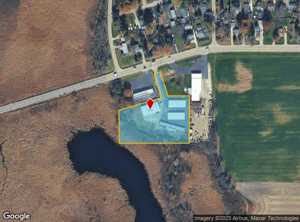
27615 Wilmot Rd, Trevor, WI 53179
NEARBY LISTINGS FOR SALE OR LEASE
-
-
View all Trevor listings for sale on LoopNet.com
Property Detail
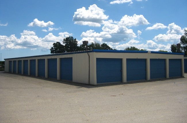
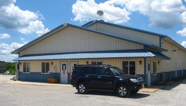
27615 Wilmot Rd
Chicago-Naperville-Elgin, IL-IN-WI
Csm# 1187
70-4-120-332-0211
HWY C 5648-F-1-A-1 PT NW 1/4 OF NW 1/4 SEC 33 T 1 R 20 LOT B CSM# 1187 V1301 P855 1989 V1589 P274 2.48 AC DOC#1140563 DOC#161
Commercialnec
Kenosha
AE
Wisconsin
55059C0144E
b
2024
2.48 AC
2024
Kenosha West
002904
Chicago
4,200 SF
DEMOGRAPHICS near 27615 Wilmot Rd
1 Mile
3 Mile
5 Mile
2024 Total Population
1,309
16,436
38,974
2029 Population
1,307
16,405
38,924
Pop Growth 2024-2029
(0.15%)
(0.19%)
(0.13%)
Average Age
40
41
42
2024 Total Households
504
6,483
15,425
HH Growth 2024-2029
(0.20%)
(0.26%)
(0.19%)
Median Household Inc
$87,236
$80,028
$86,124
Avg Household Size
2.60
2.50
2.50
2024 Avg HH Vehicles
2.00
2.00
2.00
Median Home Value
$240,000
$251,858
$259,277
Median Year Built
1973
1974
1978
Nearby Places
Map Layers
Map Styles
 Street
 Aerial
- Restaurants
- Banks
- Shops
- Fitness
- Groceries
PUBLIC TRANSPORTATION
COMMUTER RAIL
Antioch Station (North Central Service - Northeast Illinois Regional Commuter Railroad (Metra))
DRIVE
WALK
Distance
Antioch Station (North Central Service - Northeast Illinois Regional Commuter Railroad (Metra))
11 min
4.9 mi
Lake Villa Station (North Central Service - Northeast Illinois Regional Commuter Railroad (Metra))
DRIVE
WALK
Distance
Lake Villa Station (North Central Service - Northeast Illinois Regional Commuter Railroad (Metra))
19 min
9.2 mi
AIRPORT
General Mitchell International
DRIVE
WALK
Distance
General Mitchell International
44 min
40.0 mi
Nearby Properties
Address
Land Use
TOTAL SIZE
Lot Size
Zoning
Address
Land Use
TOTAL SIZE
Lot Size
Zoning
80,048 SF
10.35 AC
Address
Land Use
TOTAL SIZE
Lot Size
Zoning
111,160 SF
10.79 AC
Address
Land Use
TOTAL SIZE
Lot Size
Zoning
Address
Land Use
TOTAL SIZE
Lot Size
Zoning
6.52 AC
Address
Land Use
TOTAL SIZE
Lot Size
Zoning
61,760 SF
7.29 AC
Address
Land Use
TOTAL SIZE
Lot Size
Zoning
50,180 SF
4.08 AC
Address
Land Use
TOTAL SIZE
Lot Size
Zoning
12,000 SF
9 AC
Address
Land Use
TOTAL SIZE
Lot Size
Zoning
142,650 SF
43 AC
Address
Land Use
TOTAL SIZE
Lot Size
Zoning
480,597 SF
9.28 AC
Address
Land Use
TOTAL SIZE
Lot Size
Zoning
20,345 SF
3.54 AC
Address
Land Use
TOTAL SIZE
Lot Size
Zoning
20,254 SF
15 AC
Address
Land Use
TOTAL SIZE
Lot Size
Zoning
1,104 SF
6.98 AC
Address
Land Use
TOTAL SIZE
Lot Size
Zoning
4,400 SF
135.22 AC
Address
Land Use
TOTAL SIZE
Lot Size
Zoning
5,304 SF
49.42 AC
Address
Land Use
TOTAL SIZE
Lot Size
Zoning
9,019 SF
2.57 AC
Address
Land Use
TOTAL SIZE
Lot Size
Zoning
54,724 SF
3.89 AC
Address
Land Use
TOTAL SIZE
Lot Size
Zoning
13,680 SF
1.10 AC
Address
Land Use
TOTAL SIZE
Lot Size
Zoning
11,904 SF
6.32 AC
Address
Land Use
TOTAL SIZE
Lot Size
Zoning
8,400 SF
4.32 AC
Address
Land Use
TOTAL SIZE
Lot Size
Zoning
144,720 SF
6.35 AC
Address
Land Use
TOTAL SIZE
Lot Size
Zoning
6,360 SF
130.89 AC
Address
Land Use
TOTAL SIZE
Lot Size
Zoning
8,000 SF
2 AC
Address
Land Use
TOTAL SIZE
Lot Size
Zoning
8,000 SF
6.92 AC
Address
Land Use
TOTAL SIZE
Lot Size
Zoning
1,054 SF
39.70 AC
Address
Land Use
TOTAL SIZE
Lot Size
Zoning
349,440 SF
1.43 AC
Address
Land Use
TOTAL SIZE
Lot Size
Zoning
2,480 SF
0.56 AC
Address
Land Use
TOTAL SIZE
Lot Size
Zoning
3,819 SF
12.30 AC
Address
Land Use
TOTAL SIZE
Lot Size
Zoning
200,580 SF
2.60 AC
Address
Land Use
TOTAL SIZE
Lot Size
Zoning
11,040 SF
30.64 AC
Address
Land Use
TOTAL SIZE
Lot Size
Zoning
2,376 SF
0.87 AC
The World's #1 Commercial Real Estate Marketplace
Connect with us
© 2026 CoStar Group
The information above has been obtained from sources believed reliable. While we do not doubt its accuracy we have not verified it and make no guarantee, warranty or representation about it. It is your responsibility to independently confirm its accuracy and completeness. Any projections, opinions, assumptions, or estimates used are for example only and do not represent the current or future performance of the property. The value of this transaction to you depends on tax and other factors which should be evaluated by your tax, financial, and legal advisors. You and your advisors should conduct a careful, independent investigation of the property to determine to your satisfaction the suitability of the property for your needs.